Labour Migration in the Middle Hills of Nepal: Consequences on Land Management Strategies


1
Centre for Development and Environment, University of Bern, Mittelstrasse 43, 3012 Bern, Switzerland
2
Federal Office for the Environment FOEN, Soil Section, 3003 Bern, Switzerland
*
Author to whom correspondence should be addressed.
Sustainability 2019, 11(5), 1349; https://doi.org/10.3390/su11051349
Submission received: 23 January 2019
/
Revised: 25 February 2019
/
Accepted: 25 February 2019
/
Published: 4 March 2019
(This article belongs to the Section Sustainable Urban and Rural Development)
Abstract
:Labour migration in Nepal is having profound effects on land management. We take two examples from the hills of Nepal where the increasing trend in outmigration continues unabated and explore its consequences. The purpose of this study is to understand the impacts of the subsequent labour shortage on land management and how it affects households. We used data from two surveys and assessed land use change and degradation with a qualitative mapping method. The findings show that the local context leads to very different strategies in terms of land management. In one study area, land was left to lie fallow without any use, leading to overgrowth and forest recovery due to favourable climate conditions. In the other, land was no longer used as cropland but turned into grazing land with consequences such as land degradation. This study provides strong empirical data and also contributes to the mountain research community by shedding light on the effects of outmigration on land management in the hills of Nepal. We suggest that these effects, including the labour shortage and the increasingly important role of remittances, should be addressed in an integrative but differentiated way that takes into account the regional context.
1. Introduction
«Ils quittent un à un le pays Pour s’en aller gagner leur vieLoin de la terre où ils sont nésDepuis longtemps ils en rêvaientDe la ville et de ses secretsDu formica et du cine »«La Montagne»,Jean Ferrat, 1964, France
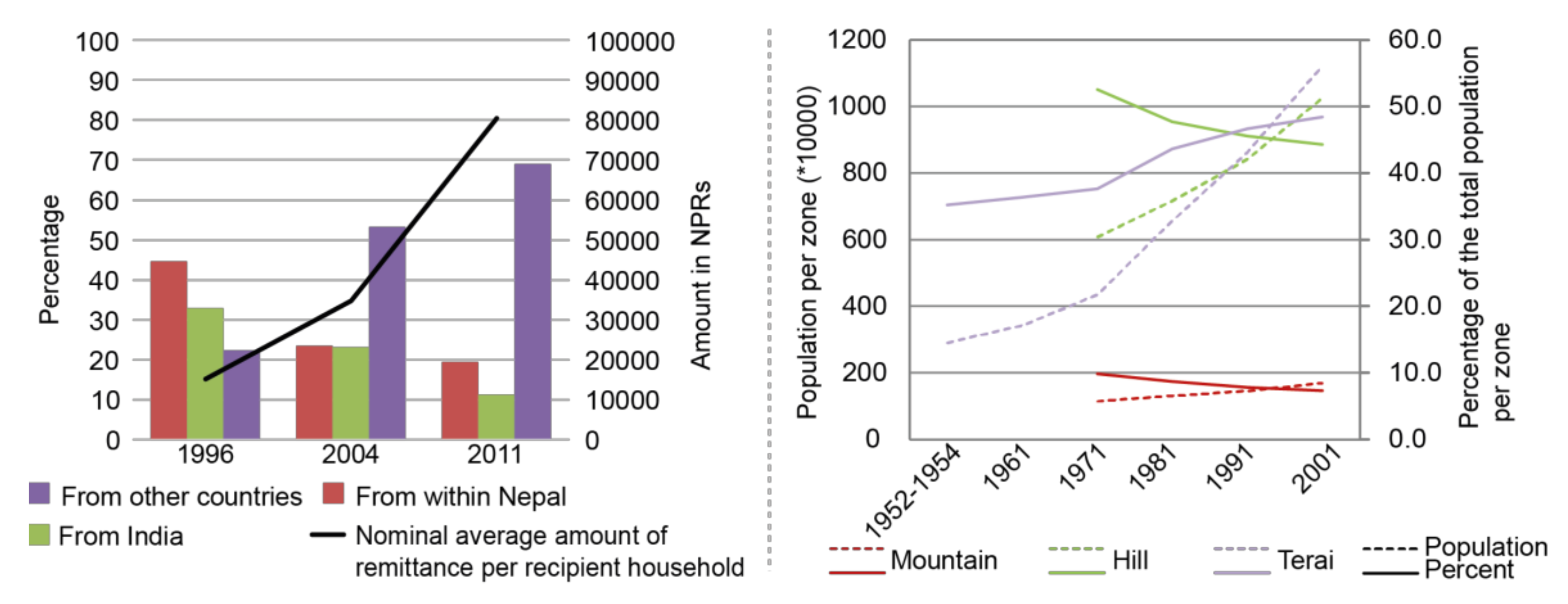
Labour migration with men and/or women seeking work abroad triggers large amounts of remittances which can exceed overseas development aid in value. Many mountain countries such as Kyrgyzstan, Tadkjikistan, Nepal, Lesotho or Armenia experience migration towards the lowlands, urbanized areas and abroad. These countries, largely affected by this phenomena [1], are among the highest recipients of remittances. The proportion of remittances reaches more than 28% of the GDP in countries such as Kyrgyzstan and Nepal [2].
There are several causes of migration. They are a combination of push factors such as poverty [3,4], lack of employment opportunities [3], education [5,6] and structural inequalities [7] and also pull factors such as better economic opportunities. Migration then leads to decisions related to education, internal migration or land use change.
Land use change results from a combination of human and ecological drivers. Studying the interplay between these drivers helps to shed light on the changes and trade-offs that actually take place [8,9]. For example, Kull et al. [10] argue that globalization factors (including migration) are important to take into account when studying forest transition and that the local context also has a significant importance. Remittances, money sent from abroad, are linked to land use, for instance through investment in machinery or new crops. This has led several authors to speak on how remittance investments are modelling new landscapes [11,12]. A cash crop boom, such as in the case of quinoa in Bolivia, can also trigger the migrants to return back [13] and that has consequences on land use. Other studies mentioned that out-migration may not result in agriculture intensification, thus leading to an increase of vegetation cover [14]. In addition, it is important to note that factors such as policy and institution can have an effect on both migration and land use [15]. Therefore, migration and land use do not have a simple cause–effect relation. As mentioned by Munroe et al. [16], “Land abandonment and ecological succession vary over space and time […]. Formerly abandoned areas can experience further agricultural or extractive activity, new settlement or a blending of many uses.”
Several studies [6,7] have used extensive household surveys to look at migration’s consequences on the area of migrants’ origins; this makes it possible to understand the effects of remittances on livelihoods and agriculture. In Latin America, migration towards the USA had large impacts on farmers in the area of origin by improving their access to land as well as technology [17,18]. Some found an increase of intensive agriculture with the introduction of machinery [6,7]. Conversely, other authors notice that in some areas only a small share of remittances is invested in agriculture; instead, they are mainly used for food, goods, and education [19,20]. The question of how important land resources are in communities with high migration has also been raised by some researchers [21,22]. In East Asia, it has been found that land ownership remains of high importance, even though incomes are becoming diversified and farmers no longer rely only on agriculture [23]. In Europe, studies have focused on land abandonment and its consequences for the landscape. For example, in Italy, the large-scale abandonment of terraced landscapes has led to extensive gully formation and terrace failures [24]. In Spain, a number of studies explored the link between land abandonment and forest fires [25]. In the Alps, studies have focused on the consequences for biodiversity and ecosystem services [26,27]; there, it was found that the recovery of forest ecosystems is one of the consequences of land abandonment [28].
Furthermore, several studies have found that women face increases in both their work burden and the cost of hiring wage labour in Latin America and Nepal [5,29,30,31]. Nonetheless, positive impacts were also identified; as women participated more in agriculture [32] and thus in economic activities, an increase in their empowerment was observed [33].
This study aims at exploring and understanding the land management strategies followed by the people who stay behind while their family members migrate. We take two examples from the hill regions in Nepal, where the increasing trend in outmigration continues unabated, and where 82.9% of the country’s population still lives in rural areas [34]. Nepal has one of the highest rates of migration in the world, with its hill regions most affected (Figure 1). The increasing tendency to migrate towards regions with higher average wage rates—such as the Gulf countries instead of India, which had been the main destination in the past (Figure 1)—has changed the dynamic of migration from seasonal to more permanent.
Studies on migration and land management in Nepal have shown the use of remittances for agricultural inputs [37]. In addition to using remittances for food and goods, other research has shown more investments into education and health, which are still lacking in quality [38,39]. Land use change in Nepal has been underway for a long time, with migration from the hills to the Terai in the 1960s leading to deforestation of large zones of previously dense forest in these lowland areas [40,41]. The population in the hills and mountains has decreased in relative terms, while the lowlands have experienced an increase in population and an intensification in agriculture (Figure 1). In many hill regions, labour shortages are causing land to be abandoned, leading not only to degradation and erosion [42,43] but also to an increase in vegetation cover. For example, forest cover, though decreasing for the country as a whole [44], is increasing in many areas of the hills [45,46,47]. Despite this trend, pockets of land use intensification can also be observed in the hills, as farmers turn to vegetable production and profitable cash crops such as coffee, where access to markets already exists.
With many studies focusing only on specific aspects of migration [48,49,50] and few studies on the link with agriculture and land [37,51,52], the linkages between outmigration and land use, especially land management strategies, is not yet fully understood. Studying these links is necessary to explain the full picture and the consequences of an increasing phenomenon in many mountain rural areas. In addition, there is a need to take into account the local context to understand these changes [10].
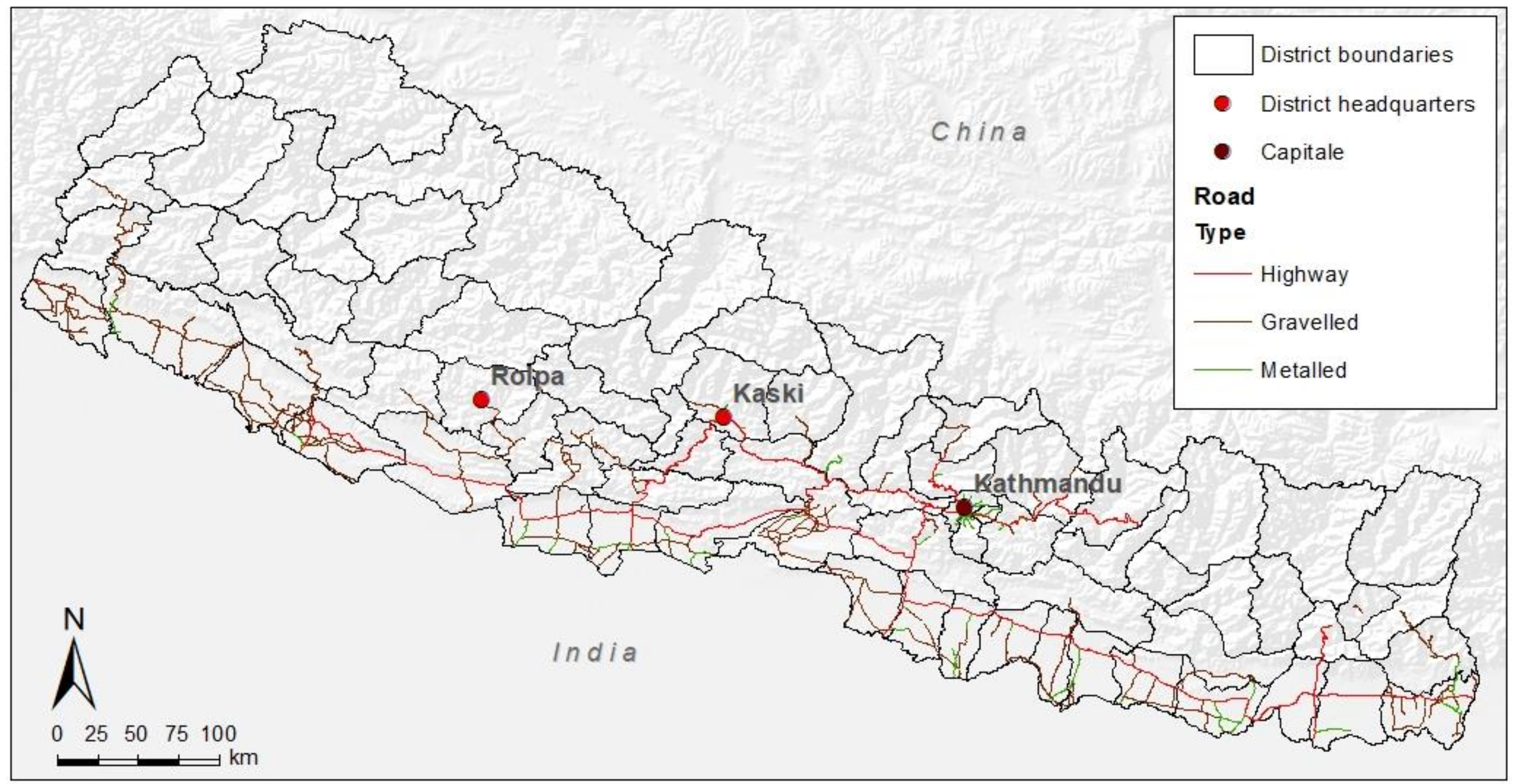
We conducted an in-depth analysis in two watersheds in the middle hills of the Western and Mid-Western Development Regions of Nepal, where migration is highest. The first case study is the Harpan watershed, which was selected within a project entitled “Sustainable Land Management in Mountain Regions of Bolivia and Nepal in the Context of Outmigration, Climate Change and Disaster Risk Reduction” [53]. The second case study, the Holeri watershed, was selected for reasons of comparison according to the criteria mentioned in Table 1.
In the context of land use change and transition in agriculture, we explored the land management strategies pursued by the people left behind. We show the migrants’ destinations, the effects of migration on local demography, and the consequences of labour shortage and how these factors affect households. We study the impacts of outmigration on land, land abandonment, and land degradation and show how migration leads to a diversity of land management strategies and subsequent land use changes. We conclude by demonstrating the complex interplay of these factors, and the difficulty in formulating a single policy/recommendation at the national level to address the complex outmigration–land management relationship in different contexts.
2. Materials and Methods
2.1. Research Area
Nepal has undergone several changes since the promulgation of the constitution in 2015. One of the most notable is the creation of seven provinces and changes in the further administrative divisions in 2017. As this research and the surveys were conducted prior to 2017, the former divisions are used in the text for coherence. Nevertheless, in Table 1, the new divisions are noted for information.
In the context of this research, the watershed of Harpan and Holeri were chosen as case studies with the following criteria: location in the middle hills of Nepal; a similar size (36–40 km2) and range of altitude (approximately between 800 and 2500 m.a.s.l.); road access; similar land use (forest, cultivated land and grazing land); a very high rate of outmigration (> 50% of households with a migrant member); the presence of land abandonment; and above average annual rainfall (> 1500 mm) (Table 1, Figure 2).
The first site, Harpan watershed is located around the upper part of the Harpan River, which flows across the area from west to east, towards Phewa Lake. The Andheri River coming from the north joins the Harpan River near the village of Thulakhet. Migration has a long history here and is significant: In the past, many men migrated to serve in the British and Indian armies. Today, migration is increasing but there is a diversification of destinations, with many men migrating to the Gulf States for employment. Many families have moved from the hills down to the city of Pokhara. A similar phenomenon is occurring at the local scale within the study area: The population is moving from the more remote uphill villages on the slopes to the more easily accessible villages at the bottom of the watershed (Ghatichhina, Thulakhet).
The second site, Holeri watershed, is crossed by one of the main roads of the district. The main river flowing south-east to west is the Sabdanda River, joined by the Bage River flowing from the north-east and the Jhenam River flowing from the north. This area was one of the first affected by the decade-long civil conflict in Nepal (1996–2006), with the Holeri police office being the first building to be attacked by the Maoist group. Seasonal migration towards India was widespread until 1996. Due to the conflict and consequent internal migration, destinations changed and international migration became more common [55]. The area and, more widely, the district of Rolpa is considered among the poorest districts of Nepal.
For each site, several settlements were chosen for surveys and focus group discussions (Table 2). The selection criteria were location (valley or on a slope), level of migration (absence for more than 6 months), presence of land abandonment, presence of land degradation, access to public transportation, and ethnicity/caste of the inhabitants. Data was gathered through key informant interviews during field visits in 2013, 2014, and 2015, with the help of staff members from local non-governmental organizations, leaders of community forest groups, and social workers.
2.2. Demographic Survey and Household Survey
Two surveys were conducted. A demographic survey asked all households of the selected settlements (N = 357 (Harpan: 169 [excluding Harpan village, see Table 2], Holeri: 188)) about household members’ age, gender, migration status, and (if migrants) destination and type of work. A second survey, the household survey (total N = 152 [89/63]), asked about the five livelihood assets [56]. We used a systematic sampling method to select and survey approximately 30% of the households in each settlement during three periods: March 2013, January–March 2014, and March–April 2015 (Table 2). The main author in collaboration with field assistants conducted this survey. We were not able to reach one-third of the households in each village, as the family members were either absent or, in some cases, not willing to participate in the interview.
Additionally, group discussions were conducted in each village. Separate focus groups for men and women were held whenever possible, to ensure the participation of both and to provide women with a comfortable space to express their views and experiences. When it was not possible to have separate discussions, we conducted a mixed focus group discussion. Topics covered characteristics of the village; outmigration and its causes, consequences, and disadvantages; land management, including land degradation and how land is managed following outmigration; and the population’s main concerns.
2.3. Assessment of Land Use Change and Degradation
The land use maps were created manually. The map of Harpan watershed (or study area) is based on a satellite image from Geoeye in 2012, and the map of Holeri watershed (or study area) is based on a Google Earth image of 2014. PCI Geomatica software was used for orthorectification and to create a high-resolution colour image. A manual classification using ArcGIS software was used to classify the land use/land cover for both maps. Land was defined as abandoned if it was terraced but had not been cultivated and used for crop production for at least the last 2 years, and was thus in the process of changing into a different land use/land cover type (shrubland, grassland, or grazing land) [47,57]. Identification of abandoned plots required information from the local population, as fieldwork took place during the dry season when most of the terraces, especially those not irrigated, were not cultivated. Characterization of the abandoned land was done as follows:
- -
- Conversion into grazing land (characterized by trampling and dung of cattle)
- -
- Conversion into grassland (characterized by high grasses and fodder production)
- -
- Conversion into shrubland (characterized by high shrubs and small trees)
Based on the land use/land cover maps, we mapped abandoned plots according to their land use/land cover by marking whether each mapped polygon covered abandoned land or not. We combined all polygons covering abandoned land to a single layer using ArcGIS and calculated the total extent of the abandoned area, as well as the percentages of each land use/land cover type.
The mapping of land degradation and sustainable land management practices was done using the mapping methodology of the World Overview of Conservation Approaches and Technologies (WOCAT) [58,59]. This is a qualitative tool that relies on expert assessments and is used to map multiple types of land degradation as well as sustainable land management practices and land use/land cover trends. The methodology is implemented with the help of a group of land experts, a questionnaire and an online database. The experts can have different backgrounds, but must have sound land use knowledge. They can be community forest chairmen, farmers, agricultural extension workers, members of organizations working in the area (e.g., local NGOs) or chairwomen of mothers’ groups.
2.4. Data Analysis
Data of the demographic survey were analysed to identify age structures and migration destinations. Categorical and numerical data from the household survey were tested and analysed using SPSS (Statistical Package for the Social Sciences). A selection of indicators derived from the household survey data were used to compare and test the differences between both watersheds. Three different tests were used. We chose the Mann-Whitney U test for independent samples, a non-parametric test, when the data did not follow a normal distribution. We also chose the T-test for independent samples for the data following a normal distribution and when the mean had to be compared, and finally, the Chi-square test was chosen for the categorical variables. For each test, the null hypothesis means that there is no statistically significant difference between the watershed of Harpan and Holeri according to the variable chosen. A geographic information system (GIS) was used for spatial analysis of migration, to map land abandonment and the results from the WOCAT mapping tool.
3. Results
Significant differences between Harpan and Holeri were found for the following indicators (household survey, N = 152) (Table 3): remittances received; land owned; number of livestock; phone, health and festival expenses; and water, road and electricity access. The respondents from Harpan receive significantly more remittances and spend more money on festivals. By contrast, the respondents from Holeri own significantly more land, have more livestock, and spend more money on phones and health. Even though not significantly different in both watersheds, respondents in Harpan spend more money on food while respondents in Holeri spend more money on transport and education. These results suggest that people in Harpan have better financial capital and better access to infrastructure as Table 3 shows, while people in Holeri seem to be more oriented towards agriculture.
3.1. Migration and Local Demography
The current population (data from the demographic survey, N = 357) presents a lack of men between 20 to 35 years old in both study sites. The younger population is more important in Holeri than in Harpan. In Harpan, women have on average fewer children, which is a sign of an on-going demographic transition. As the demographic survey further shows, in Harpan, 71.4% of the households have at least one migrant member (Thulakhet: 54.2%, Ghatichhina: 76.9%, Kuiredanda: 75%, Lower Sidhane: 71.4%, Mankanpur: 88.9%, Chisopani-Phillinghari: 87%). In Holeri, this percentage is lower: 66.5%, which is actually due to a low percentage in Dubring (Dubring: 44.8%, Lekdabang: 73.8%, Satim: 73.2% and Saliban: 80.9%).
The majority of the migrants are men. Most of them migrate within Nepal (39.3% of the migrants of both sites), either for seasonal migration, to study, or to serve in the army. The other main destinations are abroad, mainly Qatar (total percentage of migrants for both study sites 18.5%), Malaysia (14.5%) and Saudi Arabia (13.3%). People from Holeri migrate more to Malaysia (19.1% of the migrants in Holeri, 10.9% in Harpan) than to Qatar (16%, 20.5%). Expensive destinations in terms of visa costs and processing such as Japan are found in Harpan, but hardly at all in Holeri. Seasonal migrants are only found in Holeri with 9.5% of migrants going for seasonal work within Nepal or in India.
The reasons for migrating are mainly low income (data from the household survey, N= 149, 41.1% in Harpan and 47.7% in Holeri). Nonetheless, Harpan respondents also mention unemployment. In the case of Holeri, unemployment is less cited, but other reasons such as food insecurity and debts are mentioned. In the case of the non-migrating households (N = 49), reasons for staying are linked to family; for example, there is only one son or they need someone to take care of the household. People who already have a job in the area also stay. Poverty, especially in the case of Harpan, is mentioned as a reason for non-migration rather than for migration. Indeed, the poorest are often the ones who cannot afford to take a loan to migrate elsewhere (Table 4).
3.2. Consequences of Migration on Households and Social Interactions
The lack of a labour force was mentioned in every focus group discussion and has the highest impact on the households. Consequently, the work burden on those left behind is especially high. If no men are able to work in the household, the women are left to plough the land. However, this activity is forbidden by some Hindu practices, so the women are forced to choose either hiring wage labour or doing it themselves. Often, if a disaster (e.g., landslide, flood) occurs after ploughing the land, women are blamed for causing it by acting against the belief. Therefore, in many cases in Harpan watershed, when the burden is too high, they decide to abandon part of their land, often the land located furthest from the house. In Holeri, people rely more on the land than in Harpan due to a higher risk of food insecurity, and thus, women are forced to do forbidden work which is little tolerated.
“One has to cultivate crops for food”.[man from Dubring]
Few women migrate. Several reasons were mentioned, among them security, family and education. It is difficult for women to find a husband if they migrate. Some men also said that women cannot migrate because women’s migration is “bad” and they are illiterate.
“If we would get other employment opportunities I would have stopped collecting the grasses and the fuel wood. Women wouldn’t have to be dependent on men and get discriminated by them. All we do is cook and serve them”.[woman from Ghatichhina]
Despite this, women mentioned that their work in agriculture is good and that they can follow training which brings them knowledge. They also request more skill enhancement programmes. When men are at home, the men decide, but when the men are absent, the women make the decisions. The women mention that they have better “speaking power” due to male migration and absence and that they would do other jobs if they have the opportunity to do so.
Education is also a key topic for respondents of both watersheds; it was widely mentioned during the focus group discussions and can also be seen in the household survey. According to the results from the household survey (N = 152), the education level of the inhabitants differs between both watersheds and also at a more local scale within each watershed. In general, and for both watersheds, men are better educated than women. The inhabitants of Harpan have a better education level than those of Holeri. In Harpan, quality education and use of remittances to achieve that purpose are often cited by the focus group participants as an important concern. For instance, some inhabitants left their land fallow uphill and moved down to the valley floor to rent a room, in a bid to move closer to school. In Holeri, the rate of illiterate women is higher, reaching 47.6% (32% in Harpan). There are also clear differences within the watershed: Jhenam Village Development Committee (VDC) has a lower level of education than Dubring. The rate of illiterate women and men reaches, respectively, 50.8% and 30% in Jhenam VDC against 46% and 13% in Dubring. According to the local population, reasons include that the first school in the area was built in Dubring village and the former village chief promoted education. In addition, women have in general less children than before.
3.3. Consequences of Migration on Agriculture and Land Abandonment
Maize dominates crop production in both watersheds: 88.8% of the households in Harpan and 90.5% in Holeri cultivate this crop (Table 5). Apart from this, the cropping pattern varies greatly. Rice, the main crop in Nepal, is much more important in Harpan. The ability to produce rice depends on land suitability, irrigation facilities and the labour force. The irrigated fields (khet) are very labour-intensive and often located close to a source of water. Only two villages in Harpan (Chisapani and Kuiredanda) do not cultivate much rice, as their land is unsuitable for rice production. In Harpan, wheat is cultivated in addition to rice. Buckwheat is also an important traditional crop there, cultivated by 40% of the households. The lack of a labour force is changing the crop pattern, with an abandonment of crop cultivation in 6.7% of the households (Table 5). In other cases, such as in the valley bottoms, a shift towards cash crops can be noticed.
In Holeri, difficulties in cultivating rice (only one-third of the household) are due to the topography and few irrigation facilities; irrigated terraces are only found close to the valley floor. When asked about food security, some respondents mentioned that they are food secure but have to buy rice. Wheat is cultivated by almost all households (96.8%), it requires less water than rice and is a winter crop. It provides households with another staple crop after the rice season.
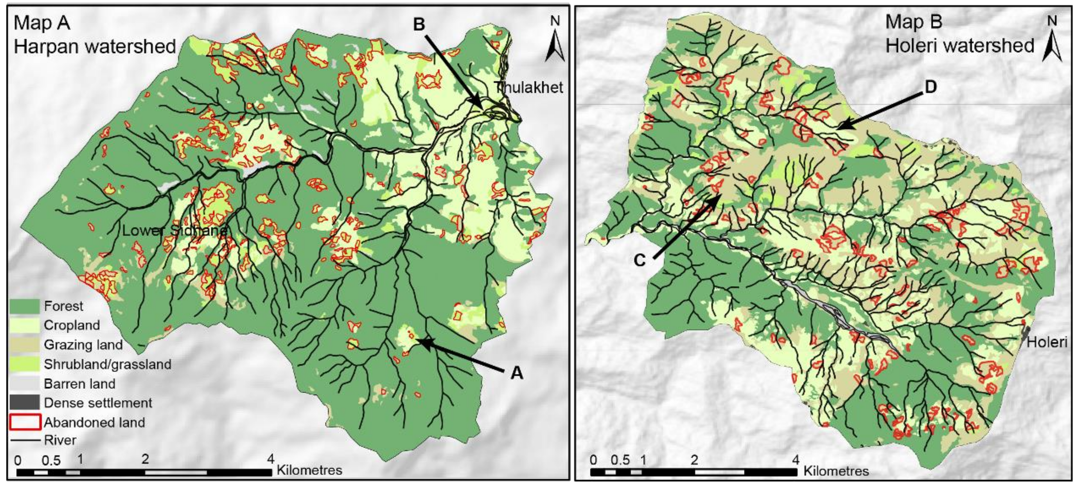
If we exclude the village of Bhadaure Tamagi, where many answers are missing, in four out of the five VDCs (in both watersheds) more than 40% of households have abandoned land (Table 6). One VDC in Harpan (Pumdi Bhumdi) presents a very low percentage of land abandonment even though 83% of the households in this village have at least one migrant member. This may be because this village is located uphill and has hardly any irrigated land and very little cropland in general in this area (Arrow A in Map A, Figure 3).
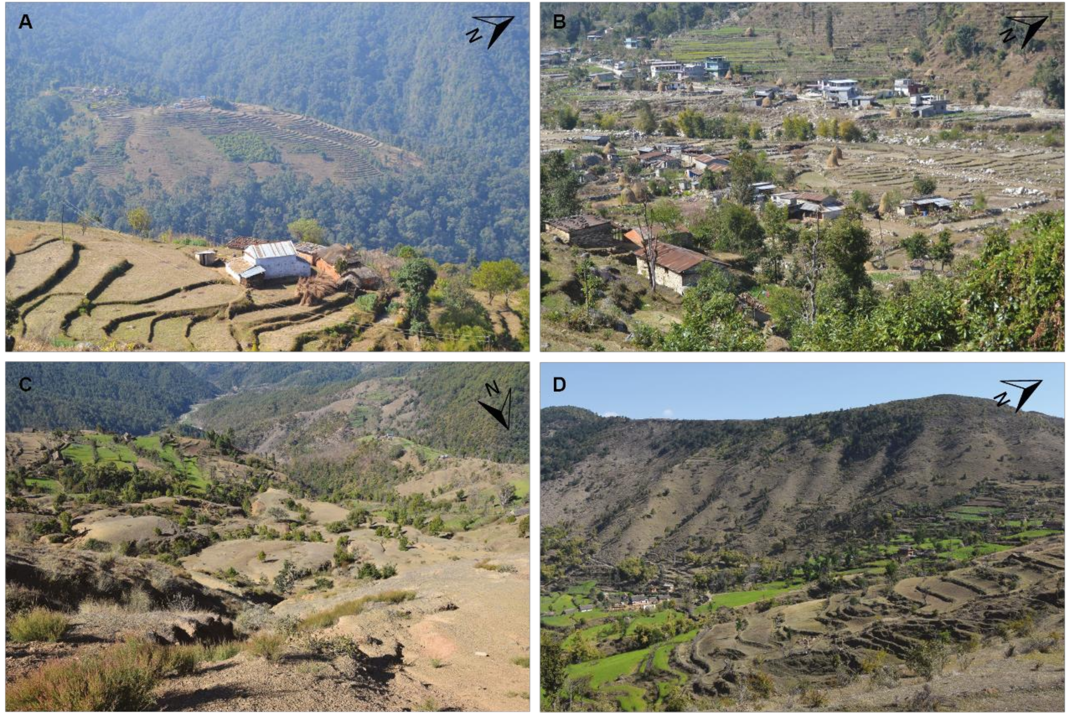
In Harpan, 52.6% of the households with abandoned land have at least one migrant member (65.6% in Holeri). Thus, households without migrants are abandoning land as well. The main reasons for both types of household abandoning land are the lack of labour force (63.2% in Harpan and 43.8% in Holeri). There are several reasons for the lack of labour. While it is due to outmigration in more than half of the cases, it is also due to fewer children per family and better and longer education. Other reasons for abandoning land are a lack of irrigation, low land productivity, unsuitability of the land, and distance from the home. In Harpan, the land used for cultivation has been reduced in quantity over the last 20 years and is now mainly located around the houses/villages. The land being abandoned is often the furthest from the settlements. The upper part of the watershed is more affected by this loss of cultivated land. Map A (Figure 3) shows extensive forest cover with abandoned plots turning into shrubland in the western and upper part of the Harpan watershed. In Lower Sidhane, for example, the cultivated land has decreased by 49% from 0.41 km2 in 1978 to 0.19 km2 in 2014 due to abandonment. In contrast, in the eastern part of the watershed there is much less abandonment. This area is the lower part of the watershed including the valley bottom (Picture B in Figure 4), where the population and the cultivated area are increasing due to better access to infrastructure. In Holeri (Map B in Figure 3), there is no distinct spatial pattern of land abandonment, though small patches are often located at the edge of the forests. Large areas of grazing land (Picture C and D, in Figure 4) are present especially in the north and north-east of the watershed.
3.4. Consequences on Land Management
Both watersheds present different land use and land management after abandonment. In Harpan, abandoned land concentrates on slopes and upper parts of the area. It is left fallow without any use, and is quickly replaced by shrubland and grassland. This process leads to the spread of invasive species and reduced land fertility due to a lack of manure. Between 1996 and 2004, the forest cover increased by 12% [47], and 47.5% of the current forest is now subject to forest management measures. Community forests (CF) have been implemented since 1993 in Harpan, and a number of projects are also influencing the forest area. The ecosystem-based adaptation (EbA) and Hariyo Ban projects funded by international organisations aim at finding solutions to adapt to climate change, and forest is part of the targeted land cover. In addition, the Panchase forest, located in the western part of the watershed, was recognized as a protected area in 2011. The rules linked to that area are very strict regarding logging, fodder collection, collection of Non-Timber Forest Products (NTFP), and grazing. The people from Harpan, especially from the upper part of the watershed, are therefore confronted with a large forest protection area which triggers some complaints from the inhabitants, for instance from Lower Sidhane:
“[…] we fear that the programme will affect our daily lives – it will restrict us from access to grass, fodder, fuel; it will be difficult for us to raise our livestock if we are denied of essential things. Either you give us enough money to buy solar [panels]; we will use it to cook our food. […] if we are not allowed to cut grass and fuel wood, how can we survive?“
In contrast, with the upper part of the Harpan watershed, there is no land abandonment in the valley floor, even though it is prone to flooding. In 1978, only a few houses were located in this area. This has changed dramatically; in 2014, 59 households lived by the riverside in the village of Thulakhet alone, where they are exposed to risks of flooding (Picture B in Figure 4). They grow cash crops such as potatoes. In addition, the increased pressure on the forest due to the growing population in the same village has led the CF committee to reduce the share of the forest that can be used per household in order to use the forest sustainably. People uphill leave their land fallow but do not sell it and hardly rent it, as they think they will come back in the future when the villages are “developed”.
In Holeri, land which is no longer used for cultivation is converted into grazing land. Farmers still produce maize, millet, oat, and wheat. Abandoned land is converted into grazing land as goat keeping has become an important component of farming and income generating strategies in recent years. Goat keeping is promoted by local NGOs and the government to help reduce costly imports, as Nepal does not produce enough to meet the high demand for goats and goat meat especially during festivals. Due to goat farming, vegetation degradation or loss has become an important issue in the watershed, also in forested lands. Very precise rules including fines for those not observing them are found in the CF constitution (CF are implemented since 1988 in Holeri watershed) regarding illegal grazing (e.g., Fine for grazing inside of the community forest: sheep, goats = NRP 5 per livestock); however, the definition of what is forest and what is not forest is not very clear and is difficult to comprehend. For instance, many CFs accept rotational grazing in their compound and new plantations planted with new seedlings are already considered a forest, in order to protect them.
In contrast to Harpan, there is no migration downwards to the valleys within the watershed in Holeri because there is currently no road there (it is planned). Inhabitants do not migrate to the village on the top of the area even though the road and bus station are located there. The reasons are the cold and windy climate up there and the little land available there for newcomers. Even still, as in Harpan, some families are moving towards the main city of the area, which is 40 km away.
In both study sites, road construction also leads to land degradation due to improper construction techniques. In combination with the loss of vegetation cover, this can lead to gullying and small landslides. Significantly, road access is mentioned as highly important in both watersheds. People also say that better road access would reduce migration.
4. Discussion
The results of this study have revealed that the aims of migration are the same across case studies: to move out of poverty, to give a good education to the future generation, to be food secure and to be economically better off than now. Nevertheless they have brought to light different strategies for coping with the effects of migration despite both study areas being of similar size, located in similar ecological regions, and affected by outmigration. This underlines again the need to take into account the local context [10]. In this context, this is partly due to the different stages of development as exemplified by the Human Development Index (HDI), but also to history. The study shows that it is very obvious that poverty mitigation plays an important role in the strategies pursued by farmers for their land use management. There are limits, however, to tackling poverty solely with migration and remittances; the poorest do not have the means to raise the upfront investment needed.
Food security is one of the main goals of migration for many households as shown in Holeri. Most of the families do use the remittances received from abroad to buy food, as shown in many other studies in different parts of Nepal [37,43,60]. The definition of food security is nevertheless ambiguous. In several cases in Holeri, people said they were food secure, but admitted having to buy their own rice. In Harpan, this phenomenon is even more pronounced, with people spending a high share of their income to buy food that they are not producing anymore [61]. Nevertheless, food security has remained an important aspect of farming; it was and still is important for households to cultivate crops and vegetables for subsistence, even though a trend from subsistence farming to cash crop production can be observed for those who own more land.
The effects of outmigration on land management in the hills of Nepal vary widely and depend on the local context. As the study shows, outmigration together with education and demographic transition are leading to profound changes in the land use of the middle hills of Nepal, the region most affected by migration in the country. On the slopes, many terraced landscapes disappear under bush and eventually forest, or are used for grazing instead of cropping, followed by potential land degradation due to overgrazing or road construction. By contrast, valley bottoms may face intensification of agriculture, especially if easily accessible by road (Figure 5).
Chen et al. [62] whose work is based on Foley et al. [63] discuss the stages of rural mobility transition with a society moving from the subsistence stage towards intensive land use. Forest transition, massive rural–urban migration and intensification of agriculture are the main aspects of this intensification stage. While the Harpan watershed follows a classical land use transition trajectory, as described by Chen 2014, and would be described by the intensification aspects, the Holeri watershed is different, though the scale of analysis is the same. In Harpan, people have become more flexible due to a better road communication network, easier access to the city, very fertile land in the valley bottoms, lower dependence on land due to higher off-farm income, and a generally better status in development (HDI). This has allowed many households to adopt a strategy that enables them to choose between working the land, labour migration, and permanent migration to the city. Harpan respondents believe they will come back when the area is “developed” (the question to raise is “by whom?”). In Holeri, by contrast, the dependency on land is still very high. The history of the conflict, the very poor road network, limited work opportunities and poverty link the people to the land and prompt them to adapt a different strategy compared to in Harpan. Many have increased livestock farming, especially goat keeping. This is an appropriate response because in view of the labour shortage and poor access, goat keeping is less labour intensive than crop production. In addition, goats are mobile when it comes to marketing, and they fetch a good price when sold. Overall, the households mentioned that they need the land to survive, quite in contrast to Harpan, where the uphill land is largely abandoned.
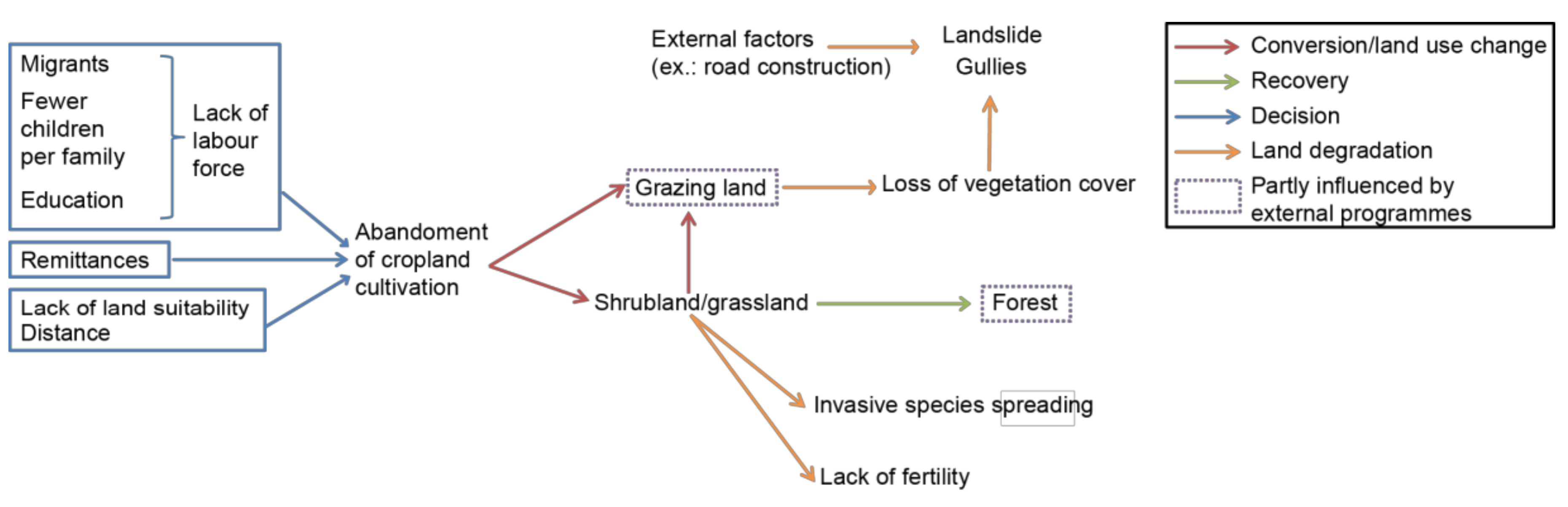
It is recognized that the lack of access to land hinders rural development by constraining the access to loans, to joining organisations or groups and to investing [64]. This inadequate access is therefore recognized as a very important cause of migration. Nevertheless, households may also benefit from land abandonment [22,65]. In Harpan, land has helped the people to migrate (e.g., income from agriculture and loan warranty) and therefore to earn a better income to sustain their household. In addition, it appears that many households abandoning land are non-migrant households. Apparently, education, fewer children per family and disinterest of youth in farming “which they regard as a “dirty job”” [66] also cause abandonment of the land (Figure 5). This differs from Holeri, where, even though diversification of income is taking place with outmigration, the land is essential.
The rural areas are in profound transformation and the land is thus serving a different role. As it is becoming less important and less strategic for some households, it would be justified to talk about emancipation from the land [21], in some case especially in terms of productive assets. Remittances have decreased the dependency on local farming as families are spending more on food [61]. Nevertheless, in many cases, the link between land, farming and outmigration as a strategy of moving out of poverty for many is crucial [22]. Interestingly, poverty is often also a hindrance to migration, as this study has shown. There is therefore a need to provide agriculture development solutions oriented to these different dynamics.
Nepal has the opportunity to effect policy changes under the new constitution (adopted in September 2015), and there are likely to be amendments in the land law. The case of Harpan watershed may be quite interesting to follow as the area is now part of a metropolitan city (as per the new boundaries) and thus under potential urban planning, as compared to a rural development municipality such as in the case of Holeri. All these developments, including a labour shortage due to demographic transition, changes in lifestyle and the increasingly important role of remittances, have to be addressed in an integrative but differentiated way that takes into account regional contexts.
5. Conclusions
This study provides strong empirical data and also contributes to the mountain research community by shedding light on the effects of outmigration on land management in the hills of Nepal. It underlines the importance of taking into account the local context in this type of research. As shown, history and poverty have very significant impacts on the way smallholder families manage the land and try to remain food secure and improve their livelihoods. Overall, a specific challenge in relation to regional food security is the lack of growth of Nepalese agriculture: only a few remittances are invested into agriculture. It should be recalled that remittances cannot replace official development aid. With this study we showed the variety of different pathways and thus the complexity of formulating specific policies and recommendations to respond to the land management–migration nexus. Therefore, a balanced development targeting the current challenges faced by the farming population has to be tackled with an innovative policy on land management adapted to the local context.
Author Contributions
Conceptualization, methodology, formal analysis, investigation, writing—original draft preparation, S.J., G.S. and T.K.; Writing—review and editing, S.J., G.S. and T.K.; visualization, S.J.; Supervision, G.S. and T.K.; Project administration, G.S.; Funding acquisition, G.S.
Funding
This study has been carried with the support of a 2-year study (2012–2014) which was financed by the Swiss Network for International Studies, based in Geneva and one year support by the Centre for Development and Environment of the University of Bern.
Acknowledgments
We would like to send sincere and deep thanks to the communities and their people who helped us during the fieldwork and who always welcomed us with a smile, especially to the communities of Ghatichina, Thulakhet, Lower Sidhane, Mankanpur, and Chisopani-Philinghari, Lekdgabang, Satim, Saliban and Dubring. Thanks to Sebastian Oggier, Mina Joshi, Min Mahatara, Pratima Baral and Gitta Shrestha for their valuable help for the field work. A special thanks to the Rupantaran Nepal NGO and Brahma Dhoj Gurung for helping to set up the second case study and for the valuable assistance in the field work. Thank you to Tina Hirschbuehl and Claire Shaw for language editing this article.
Conflicts of Interest
The authors declare no conflict of interest. The funders had no role in the design of the study; in the collection, analyses, or interpretation of data; in the writing of the manuscript, or in the decision to publish the results.
References
- Kohler, T.; Balsiger, J.; Rudaz, G.; Debarbieux, B.; Pratt, J.; Maselli, D. Green Economy and Institutions for Sustainable Mountain Development: From Rio 1992 to Rio 2012 and Beyond; Swiss Agency for Development and Cooperation (SDC): Bern, Switzerland, 2015. [Google Scholar]
- World Bank. Personal Remittances, Received (% of GDP); World Bank: Washington, DC, USA, 2018; Available online: https://data.worldbank.org/indicator/BX.TRF.PWKR.DT.GD.ZS?year_high_desc=true (accessed on 15 December 2018).
- Government Office for Science. Foresight, Migration and Global Environmental Change; Final Project Report; The Government Office for Science: London, UK, 2011.
- Balderrama Mariscal, C.; Tassi, N.; Miranda, A.R.; Canedo, L.A.; Cazorla, I. Rural Migration in Bolivia: The Impact of Climate Change, Economic Crisis and State Policy; IIED Human Settlements Working Paper 45; IIED: London, UK, 2011. [Google Scholar]
- Lipton, M. Migration from Rural Areas of Poor Countries: The Impact on Rural Productivity and Income Distribution. World Dev. 1980, 8, 1–24. [Google Scholar] [CrossRef]
- Mendola, M. Migration and technological change in rural households: Complements or substitutes? J. Dev. Econ. 2008, 85, 150–175. [Google Scholar] [CrossRef]
- Yarnall, K.; Price, M. Migration, Development and a New Rurality in the Valle Alto, Bolivia. J. Lat. Am. Geogr. 2010, 9, 107–124. [Google Scholar] [CrossRef]
- Verburg, P.H.; Crossman, N.; Ellis, E.C.; Heinimann, A.; Hostert, P.; Mertz, O. Land system science and sustainable development of the earth system: A global land project perspective. Anthropocene 2015, 12, 29–41. [Google Scholar] [CrossRef]
- Noszczyk, T. A review of approaches to land use changes modeling. Hum. Ecol. Risk Assess. Int. J. 2018, 1–29. [Google Scholar] [CrossRef]
- Kull, C.A.; Ibrahim, C.K.; Meredith, T.C. Tropical Forest Transitions and Globalization:Neo-Liberalism, Migration, Tourism, and International Conservation Agendas AU-Kull, Christian A. Soc. Nat. Resour. 2007, 20, 723–737. [Google Scholar] [CrossRef]
- McKay, D. Reading remittance landscapes: Female migration and agricultural transition in the Philippines. Geogr. Tidsskr. Dan. J. Geogr. 2005, 105, 89–99. [Google Scholar] [CrossRef]
- Hostettler, S. Land Use Changes and Transnational Migration-the Impact of Remittances in Western Mexico; EPFL: Lausanne, Switzerland, 2007. [Google Scholar]
- Tschopp, M. The quinoa boom and the commoditisation debate: Critical reflections on the re-emergence of a peasantry in the Southern Altiplano. Alternautas 2018, 5, 64–81. [Google Scholar]
- Lambin, E.F.; Meyfroidt, P. Land use transitions: Socio-ecological feedback versus socio-economic change. Land Use Policy 2010, 27, 108–118. [Google Scholar] [CrossRef]
- Braimoh, A.K. Seasonal migration and land-use change in Ghana. Land Degrad. Dev. 2004, 15, 37–47. [Google Scholar] [CrossRef]
- Munroe, D.K.; van Berkel, D.B.; Verburg, P.H.; Olson, J.L. Alternative trajectories of land abandonment: Causes, consequences and research challenges. Curr. Opin. Environ. Sustain. 2013, 5, 471–476. [Google Scholar] [CrossRef]
- Radel, C.; Schmook, B. Male Transnational Migration and its Linkages to Land-Use Change in a Southern Campeche Ejido. J. Lat. Am. Geogr. 2008, 7, 59–84. [Google Scholar]
- Schmook, B.; Radel, C. International Labor Migration from a Tropical Development Frontier: Globalizing Households and an Incipient Forest Transition. Hum. Ecol. 2008, 36, 891–908. [Google Scholar] [CrossRef]
- Adger, W.N.; Kelly, P.M.; Winkels, A.; Huy, L.Q.; Locke, C. Migration, Remittances, Livelihood Trajectories, and Social Resilienc. J. Hum. Environ. 2002, 31, 358–367. [Google Scholar] [CrossRef]
- McCarthy, N.; Carletto, G.; Davis, B.; Maltsoglou, I. Assessing the Impact of Massive Out-Migration on Agriculture; FAO: Rome, Italy, 2006. [Google Scholar]
- Rigg, J. Land, Farming, Livelihoods, and Poverty: Rethinking the Links in the Rural South. World Dev. 2005, 34, 180–202. [Google Scholar] [CrossRef]
- Sunam, R.K.; McCarthy, J.F. Reconsidering the links between poverty, international labour migration, and agrarian change: Critical insights from Nepal. J. Peasant Stud. 2016, 43, 39–63. [Google Scholar] [CrossRef]
- Rigg, J.; Salamanca, A.; Thompson, E.C. The puzzle of East and Southeast Asia’s persistent smallholder. J. Rural Stud. 2016, 43, 118–133. [Google Scholar] [CrossRef]
- Tarolli, P.; Preti, F.; Romano, N. Terraced landscapes: From an old best practice to a potential hazard for soil degradation due to land abandonment. Anthropocene 2014, 6, 10–25. [Google Scholar] [CrossRef]
- Romero-Calcerrada, R.; Perry, G.L.W. The role of land abandonment in landscape dynamics in the SPA ‘Encinares del río Alberche y Cofio, Central Spain, 1984–1999. Landsc. Urban Plan. 2004, 66, 217–232. [Google Scholar] [CrossRef]
- Cramer, V.A.; Hobbs, R.J.; Standish, R.J. What’s new about old fields? Land abandonment and ecosystem assembly. Trends Ecol. Evol. 2008, 23, 104–112. [Google Scholar] [CrossRef] [PubMed]
- Beilin, R.; Lindborg, R.; Stenseke, M.; Pereira, H.M.; Llausàs, A.; Slätmo, E.; Cerqueira, Y.; Navarro, L.; Rodrigues, P.; Reichelt, N.; et al. Analysing how drivers of agricultural land abandonment affect biodiversity and cultural landscapes using case studies from Scandinavia, Iberia and Oceania. Land Use Policy 2014, 36, 60–72. [Google Scholar]
- Gellrich, M.; Baur, P.; Koch, B.; Zimmermann, N.E. Agricultural land abandonment and natural forest re-growth in the Swiss mountains: A spatially explicit economic analysis. Agric. Ecosyst. Environ. 2007, 118, 93–108. [Google Scholar] [CrossRef]
- Gisbert, M.E.; Painter, M.; Quiton, M. Gender Issues Associated with Labor Migration and Dependence on Off-Farm Income in Rural Bolivia. Hum. Organ. 1994, 53, 110–122. [Google Scholar] [CrossRef]
- Mendola, M. Rural Out-Migration and Economic Development at Origin. What Do We Know? Sussex Migration Working Paper No 40; University of Sussex: Brighton, UK, 2006. [Google Scholar]
- Gartaula, H.N.; Visser, L.; Niehof, A. Socio-Cultural Dispositions and Wellbeing of the Women Left Behind: A Case of Migrant Households in Nepal. Soc. Indic. Res. 2012, 108, 401–420. [Google Scholar] [CrossRef] [PubMed]
- Lastarria-Cornhiel, S. Feminization of Agriculture: Trends and Driving Forces; Background Paper for the World Development Report 2008; World Bank: Washington, DC, USA, 2008. [Google Scholar]
- Paudel Khatiwada, S.; Deng, W.; Paudel, B.; Khatiwada, J.; Zhang, J.; Wan, J. A Gender Analysis of Changing Livelihood Activities in the Rural Areas of Central Nepal. Sustainability 2018, 10, 4034. [Google Scholar] [CrossRef]
- Government of Nepal. Population Monograph of Nepal; Economic Demography; Central Bureau of Statistics: Kathmandu, Nepal, 2014; Volume 3.
- Government of Nepal. Nepal Living Standards Survey; Central Bureau of Statistics, Ed.; Government of Nepal: Kathmandu, Nepal, 2011.
- Government of Nepal. Nepal Population Report; Ministry of Health and Population: Kathmandu, Nepal, 2011.
- Maharjan, A.; Bauer, S.; Knerr, B. Migration for Labour and Its Impact on Farm Production in Nepal; Working Paper IV; Centre for the Study of Labour and Mobility: Kathmandu, Nepal, 2013. [Google Scholar]
- Kollmair, M.; Manandhar, S.; Subedi, B.; Thieme, S. New figures for old stories: Migration and remittances in Nepal. Migr. Lett. 2006, 3, 151–160. [Google Scholar] [CrossRef]
- Kollmair, M.; Hoermann, B. Labour Migration, Opportunities and challenges for mountain livelihoods. In Sustainable Mountain Development; ICIMOD: Kathmandu, Nepal, 2011. [Google Scholar]
- Massey, D.S.; Axinn, W.G.; Ghimire, D.J. Environmental change and out-migration: Evidence from Nepal. Pop. Environ. 2010, 32, 109–136. [Google Scholar] [CrossRef] [PubMed]
- Seddon, D. Agrarian Change and the Long-Term Transformation of Rural Livelihoods in Nepal. In Sustainable Mountain Development; ICIMOD: Kathmandu, Nepal, 2011. [Google Scholar]
- Khanal, R.; Watanabe, T. Abandonment of Agricultural Land and Its Consequences. Mt. Res. Dev. 2006, 26, 32–40. [Google Scholar] [CrossRef]
- Adhikari, J.; Hobley, M. Everyone is Leaving-Who Will Sow Our Fields? The Effects of Migration from Khotang District to the Gulf and Malaysia; Swiss Agency for Development and Cooperation: Kathmandu, Nepal, 2011. [Google Scholar]
- Government of Nepal. Environment Statistics of Nepal 2013; Central Bureau of Statistics: Kathmandu, Nepal, 2014.
- Jackson, W.J.; Tamrakar, R.M.; Hunt, S.; Shepherd, K.R. Land-Use Changes in Two Middle Hills Districts of Nepal. Mt. Res. Dev. 1998, 18, 193–212. [Google Scholar] [CrossRef]
- Gautam, A.P.; Webb, E.L.; Shivakoti, G.P.; Zoebisch, M.A. Land use dynamics and landscape change pattern in a mountain watershed in Nepal. Agric. Ecosyst. Environ. 2003, 99, 83–96. [Google Scholar] [CrossRef]
- Jaquet, S.; Schwilch, G.; Hartung-Hofmann, F.; Adhikari, A.; Sudmeier-Rieux, K.; Shrestha, G.; Liniger, H.P.; Kohler, T. Does outmigration lead to land degradation? Labour shortage and land management in a western Nepal watershed. Appl. Geogr. 2015, 62, 157–170. [Google Scholar]
- Kern, A.; Müller-Böker, U. The middle space of migration: A case study on brokerage and recruitment agencies in Nepal. Geoforum 2015, 65, 158–169. [Google Scholar] [CrossRef]
- Poertner, E.; Junginger, M.; Müller-Böker, U. Migration in Far-West Nepal. Crit. Asian Stud. 2011, 43, 23–47. [Google Scholar] [CrossRef] [PubMed]
- Thieme, S.; Wyss, S. Migration Patterns and Remittance Transfer in Nepal: A Case Study of Sainik Basti in Western Nepal. Int. Migr. 2005, 43, 59–98. [Google Scholar] [CrossRef]
- Khanal, U. Why are farmers keeping cultivatable lands fallow even though there is food scarcity in Nepal? Food Secur. 2018, 10, 603–614. [Google Scholar] [CrossRef]
- Chaudhary, S.; Wang, Y.; Khanal, N.; Xu, P.; Fu, B.; Dixit, A.; Yan, K.; Liu, Q.; Lu, Y. Social Impact of Farmland Abandonment and Its Eco-Environmental Vulnerability in the High Mountain Region of Nepal: A Case Study of Dordi River Basin. Sustainability 2018, 10, 2331. [Google Scholar]
- Schwilch, G.; Adhikari, A.; Jaboyedoff, M.; Jaquet, S.; Kaenzig, R.; Liniger, H.; Penna, I.M.; Sudmeier-Rieux, K.; Upreti, B.R. Impacts of Outmigration on Land Management in a Nepali Mountain Area. In Identifying Emerging Issues in Disaster Risk Reduction, Migration, Climate Change and Sustainable Development: Shaping Debates and Policies; Sudmeier-Rieux, K., Ed.; Springer International Publishing: Cham, Germany, 2017; pp. 177–194. [Google Scholar]
- Government of Nepal and United Nation Development Programme. Nepal Human Development Report 2014, Beyond Geography, Unlocking Human Potential; Government of Nepal and United Nation Development Programme: Kathmandu, Nepal, 2014.
- Hagen-Zanker, J.; Mallett, R.; Ghimire, A.; Shah, Q.A.; Upreti, B.; Abbas, H. Migration from the Margins: Mobility, Vulnerability and Inevitability in Mid-Western Nepal and North-Western Pakistan; Researching Livelihoods and Services Affected by Conflict; O.D. Institute: London, UK, 2014. [Google Scholar]
- DFID. Sustainable Livelihoods Guidance Sheet; Department for International Development: London, UK, 1999. [Google Scholar]
- Hartung-Hofmann, F. Land Use and Land Cover Changes in the Context of Agricultural Abandonment. A Case Study in the Kaski District Area, Pokhara, Nepal; University of Bern: Bern, Switzerland, 2015. [Google Scholar]
- Liniger, H.P.; Van Lynden, G.; Nachtergaele, F.; Schwilch, G.; Biancalani, R. Questionnaire for Mapping Land Degradation and Sustainable Land Management; CDE: Bern, Switzerland; FAO: Rome, Italy; ISRIC: Wageningen, The Netherlands, 2008; p. 45. [Google Scholar]
- Schwilch, G.; Bestelmeyer, B.; Bunning, S.; Critchley, W.; Herrick, J.; Kellner, K.; Liniger, H.P.; Nachtergaele, F.; Ritsema, C.J.; Schuster, B.; et al. Experiences in Monitoring and Assessment of Sustainable Land Management. Land Degrad. Dev. 2011, 22, 214–225. [Google Scholar] [CrossRef]
- Tamang, S.; Paudel, K.P.; Shrestha, K.K. Feminization of agriculture and its implications for food security in rural Nepal. J. For. Livelihood 2014, 12, 20–32. [Google Scholar]
- Sunam, R.; Adhikari, J. How does Transnational Labour Migration Shape Food Security and Food Sovereignty? Evidence from Nepal. Anthropol. Forum 2016, 26, 248–261. [Google Scholar] [CrossRef]
- Chen, R.; Ye, C.; Cai, Y.; Xing, X.; Chen, Q. The impact of rural out-migration on land use transition in China: Past, present and trend. Land Use Policy 2014, 40, 101–110. [Google Scholar] [CrossRef]
- Foley, J.A.; DeFries, R.; Asner, G.P.; Barford, C.; Bonan, G.; Carpenter, S.R.; Chapin, S.; Coe, M.T.; Daily, G.C.; Gibbs, H.K.; et al. Global Consequences of Land Use. Science 2005, 309, 570–574. [Google Scholar] [CrossRef] [PubMed]
- Haggblade, S.; Hazell, P.B.; Reardon, T. Transforming the Rural Nonfarm Economy: Opportunities and Threats in the Developing World; IFPRI: Baltimore, MD, USA, 2007. [Google Scholar]
- Jaquet, S.; Shrestha, G.; Kohler, T.; Schwilch, G. The Effects of Migration on Livelihoods, Land Management, and Vulnerability to Natural Disasters in the Harpan Watershed in Western Nepal. Mt. Res. Dev. 2016, 36, 494–505. [Google Scholar] [CrossRef]
- Gartaula, H.N.; Visser, L.; Niehof, A. Shifting perceptions of food security and land in the context of labour out-migration in rural Nepal. Food Secur. 2012, 4, 181–194. [Google Scholar] [CrossRef]
Figure 1.
Origin of remittances over time and mean annual amount of remittances received in NPRs, (USD 1 is approximately NPR 110) [35] (left); population distribution by ecological zones in percentage, 1950s–2001 (right) [36].

Figure 2.
Map of Nepal based on administrative boundaries prior to 2017 (source: based on ICIMOD data).
Figure 2.
Map of Nepal based on administrative boundaries prior to 2017 (source: based on ICIMOD data).

Figure 3.
Location of the abandoned land in both watersheds. The capital letters indicate the location of the pictures in Figure 4.
Figure 3.
Location of the abandoned land in both watersheds. The capital letters indicate the location of the pictures in Figure 4.

Figure 4.
A is located in the upper Harpan watershed. The forest belongs to the community and the Panchase protected forest. B is the valley floor, in the village of Thulakhet. C is in the Holeri watershed above Saliban and suffers from gully problems due to the decrease in vegetation cover and the construction of a road. D is in the village of Satim which is surrounded by grazing land.

Figure 5.
Land use change.


Table 1.
Characteristics of study watersheds (source: own investigations unless otherwise stated).
| Watershed | Harpan | Holeri |
|---|---|---|
| Village Development Committees (VDC) (lower administrative level until 2017) | Bhadaure Tamagi, Chapakot, Pumdi Bhumdi | Dubring, Jhenam |
| Administrative unit (as from 2017) | Pokhara metropolitan city | Runtigadi rural municipality |
| District | Kaski | Rolpa |
| Provinces (as from 2017) | Gandaki Pradesh (Province 4) | Province 5 |
| Closest important city | Pokhara (15 km) | Ghorahi (40 km) |
| Area | 36 km2 | 40 km2 |
| Altitude (range) | 825–2517 m.a.s.l. | 931–2135 m.a.s.l. |
| Precipitationa | 4048 mm (Bhadaure Deurali station) b | 1673 mm (Libang station) c |
| Temperaturea | 15–26 °C (Pokhara station, 827 m.a.s.l.) 12–20 °C (Lumle station, 1740 m.a.s.l.) b | 16–28 °C (Ghorahi station, 634 m.a.s.l.), 14–24 °C (Salyan Bazar station, 1457 m.a.s.l.) c |
| Dominant land use/land coverd | ||
| Forest | 70% | 41% |
| Cultivated land | 26% e | 21% f |
| Grazing land | - | 33% |
| Land abandonment | ||
| Percentage of the total area | 6% | 4% |
| Percentage of the terraced land | 25% | 16% |
| Number of settlements | 21 | 30 |
| Ethnicity/caste | Gurung, Brahmin, Chhetri, Dalit | Magar, Dalit, and Brahmin/Chhetri |
| HDI (Human Development Index)g | Among the 10 most developed districts | Among the 10 least developed districts in Nepal |
Notes: a Data retrieved from the climate portal: http://www.dhm.gov.np/dpc/ (Department of Hydrology and Meteorology, Government of Nepal). b Bhadaure Deurali station, 1600 m.a.s.l., 1.5 km from the watershed, Pokhara station, 827 m.a.s.l., 11 km from the watershed, Lumle station, 1740 m.a.s.l., 12 km from the watershed. c Libang station, 1270 m.a.s.l., 20 km from the watershed, Ghorahi station, 634 m.a.s.l., 17 km from the watershed, Salyan Bazar station, 1457 m.a.s.l., 30 km from the watershed. d The land use information comes from the mapping activities done in 2014 and 2015, see methods section. e Irrigated (khet) and non-irrigated (bari). f Mostly (non-irrigated (bari). g Data from a joint government and UNDP report [54]
Table 2.
Surveys and focus group discussions summary.
| Total Number of Households (All Were Surveyed for the Demographic Survey, Unless Otherwise Stated) | Number of Household Surveys (% of Total Households) | Number of Focus Group Discussions | |
|---|---|---|---|
| Harpan | |||
| Chisapani and Phillinghari a | 24 | 8 (33%) | 2 (men, women) |
| Harpan | 148 b | 31 (21%) | 1 (mixed) |
| Mankanpur | 27 | 9 (33%) | 2 (men, women) |
| Lower Sidhane | 21 | 9 (43%) | 2 (men, mixed) |
| Kuiredanda | 12 c (21) | 7 (33% or 58%) | 1 (men) d |
| Ghatichhina | 26 | 13 (50%) | 2 (men, women) |
| Thulakhet | 59 | 12 (20%) | - e |
| Total | 317 (326) | 89 (27% or 28%) | 10 |
| Holeri | |||
| Dubring | 58 | 24 (41%) | 2 (men, women) |
| Lekdabang | 42 | 11 (26%) | 2 (men, women) |
| Saliban | 47 | 15 (32%) | 2 (men, women) |
| Satim | 41 | 13 (32%) | 1 (women) d |
| Total | 188 | 63 (33%) | 7 |
Notes: a Phillinghari is very small, with only six households. For the demographic survey, it was merged with the nearby village of Chisapani. b Harpan was not chosen for a demographic survey for logistical reasons. c During the collection of information on the villages, 21 households were counted in Kuiredanda. At the time of the demographic survey, only 12 households were counted. This might be due to an error. However, the village of Kuiredanda is emptying quickly due to high outmigration of entire families, lack of land ownership, and unsuitability for land cultivation. d In Kuiredanda, it was very difficult to gather enough women willing to participate in a discussion. In Satim, alcoholism is a big problem among the male population. The gathering of men for the discussion had to be postponed a number of times and was finally cancelled, due to the inability to gather enough sober inhabitants willing to participate. e The focus group could not be held in Thulakhet for logistical reasons.
Table 3.
Statistical tests with selected indicators to compare the two watersheds (USD 1 is approximately NPR 100, data from the household survey, N = 152). Bold indicates statistically significant differences.
Table 3.
Statistical tests with selected indicators to compare the two watersheds (USD 1 is approximately NPR 100, data from the household survey, N = 152). Bold indicates statistically significant differences.
| Watershed | |||
|---|---|---|---|
| Harpan | Holeri | ||
| Average | Average | Mann-Whitney U Test for Independent Samples, p-Value (Rejected if p-Value < 0.05). | |
| Remittances received/month (NRP) | 20,632 | 13,475 | 0.033 |
| Land owned (ha) | 0.4 | 0.9 | 0.001 |
| Total number of livestock | 3.6 | 12.5 | < 0.001 |
| Total number of goods | 3.1 | 2.7 | 0.489 |
| Phone expenses/month (NRP) | 989 | 1083 | 0.019 |
| Transport expenses/month (NRP) | 1878 | 2582 | 0.133 |
| Health expenses/month (NRP) | 4201 | 6069 | 0.005 |
| Education expenses/month (NRP) | 4441 | 5824 | 0.253 |
| Average | Average | T-test for Independent samples, p-value (rejected if p-value < 0.05). | |
| Food expenses/month (NRP) | 9526 | 5564 | 0.172 |
| Festival expenses/month (NRP) | 2183 | 1159 | < 0.001 |
| Percentage | Percentage | Test Chi-square, p-value (rejected if p-value < 0.05). | |
| Water access | 82.0% | 14.3% | < 0.001 |
| Electricity access | 96.6% | 79.4% | < 0.001 |
| Road access | 88.8% | 41.3% | < 0.001 |
Table 4.
Reasons for migrating and not migrating in percent (in percent of households).
| Watershed | ||
|---|---|---|
| Harpan | Holeri | |
| Reasons for migrating | (N = 56) | (N = 44) |
| Army job | 0.0% | 2.3% |
| Business | 1.8% | 0.0% |
| Employment | 37.5% | 13.6% |
| Food insecurity | 0.0% | 4.5% |
| Debt | 0.0% | 4.5% |
| Low income | 41.1% | 47.7% |
| Multiple | 19.6% | 18.2% |
| Poverty | 0.0% | 2.3% |
| NA | 0.0% | 6.8% |
| Total | 100.0% | 100.0% |
| Reasons for not migrating | (N = 30) | (N = 19) |
| To stay with the family | 13.3% | 42.1% |
| To work locally | 16.7% | 15.8% |
| Poverty | 16.7% | 0.0% |
| Ill health | 6.7% | 5.3% |
| To pursue education in Nepal | 0.0% | 10.5% |
| In process of preparing migration | 0.0% | 5.3% |
| Lack of education | 0.0% | 5.3% |
| No passport, or citizenship issue | 3.3% | 5.3% |
| Good situation in the area | 3.3% | 0.0% |
| Lack of awareness about migration possibilities | 3.3% | 0.0% |
| NA | 36.7% | 10.5% |
| Total | 100% | 100% |
Table 5.
Crops cultivated by the households in both watersheds.
| Watershed | |||||
|---|---|---|---|---|---|
| Harpan | Holeri | ||||
| N | (%) | N | (%) | ||
| Crops | Maize | 79 | 88.80 | 57 | 90.50% |
| Rice | 65 | 73.00% | 22 | 34.90% | |
| Buckwheat | 36 | 40.40% | 0 | 0.00% | |
| Millet | 22 | 24.70% | 3 | 4.80% | |
| Mustard | 15 | 16.90% | 2 | 3.20% | |
| Wheat | 8 | 9.00% | 61 | 96.80% | |
| Barley | 1 | 1.10% | 0 | 0.00% | |
| Oat | 0 | 0.00% | 16 | 25.40% | |
| No crops | 6 | 6.70% | 0 | 0.00% | |
Table 6.
Percentage of households with abandoned land per VDCs in Harpan and Holeri watersheds.
| Abandonment of Land | Bhadaure Tamagi | Chapakot | Pumdi Bhumdi | Dubring | Jhenam | Total | |
|---|---|---|---|---|---|---|---|
| Yes | N | 30 | 7 | 1 | 10 | 22 | 70 |
| % | 41.70% | 77.80% | 12.50% | 41.70% | 56.40% | 46.10% | |
| No | N | 18 | 2 | 7 | 14 | 17 | 58 |
| % | 25.00% | 22.20% | 87.50% | 58.30% | 43.60% | 38.20% | |
| NA | N | 24 | 0 | 0 | 0 | 0 | 24 |
| % | 33.30% | 0.00% | 0.00% | 0.00% | 0.00% | 15.80% | |
| Total | N | 72 | 9 | 8 | 24 | 39 | 152 |
| % | 100.00% | 100.00% | 100.00% | 100.00% | 100.00% | 100.00% |
© 2019 by the authors. Licensee MDPI, Basel, Switzerland. This article is an open access article distributed under the terms and conditions of the Creative Commons Attribution (CC BY) license (http://creativecommons.org/licenses/by/4.0/).
Share and Cite
MDPI and ACS Style
Jaquet, S.; Kohler, T.; Schwilch, G. Labour Migration in the Middle Hills of Nepal: Consequences on Land Management Strategies. Sustainability 2019, 11, 1349. https://doi.org/10.3390/su11051349
AMA Style
Jaquet S, Kohler T, Schwilch G. Labour Migration in the Middle Hills of Nepal: Consequences on Land Management Strategies. Sustainability. 2019; 11(5):1349. https://doi.org/10.3390/su11051349
Chicago/Turabian StyleJaquet, Stéphanie, Thomas Kohler, and Gudrun Schwilch. 2019. "Labour Migration in the Middle Hills of Nepal: Consequences on Land Management Strategies" Sustainability 11, no. 5: 1349. https://doi.org/10.3390/su11051349
Note that from the first issue of 2016, this journal uses article numbers instead of page numbers. See further details here.