Relationship between Diffuse CO2 Degassing and Volcanic Activity. Case Study of the Poás, Irazú, and Turrialba Volcanoes, Costa Rica
 Matthieu Epiard1*
  Geoffroy Avard2
  J. Maarten de Moor2
  María Martínez Cruz2
  Gustav Barrantes Castillo3 Henriette Bakkar4
- 1Geosciences Paris Sud Laboratory, Paris XI University, Orsay, France
- 2Observatorio Vulcanológico y Sismológico de Costa Rica, Universidad Nacional, Heredia, Costa Rica
- 3Escuela de Ciencias Geográficas, Universidad Nacional, Heredia, Costa Rica
- 4Red Sismológica Nacional, Instituto Costarricense de Electricidad, San José, Costa Rica
Active volcanoes exhibit diffuse gas emanations through the ground, the most abundant species of which is CO2. However, the relationship between diffuse degassing and volcanic activity is not often clear and some volcanoes may have low diffuse degassing levels despite having strong volcanic activity. The main goals of this study are to quantify diffuse CO2 degassing and determine whether patterns exist in relation to volcanic activity through the study of Turrialba, Poás, and Irazú, three active volcanoes in Costa Rica which are at different stages of activity. Structural controls of spatial distribution of diffuse degassing were also investigated. Measurement campaigns were conducted using the accumulation chamber method coupled with 10 cm depth ground temperature sampling with the aim of estimating the total diffuse CO2 degassing budget. The total amount of CO2 emitted diffusely by each volcano is ~113 ± 46 t/d over ~0.705 km2 for Turrialba, 0.9 ± 0.5 t/d for Poás over ~0.734 km2, 3.8 ± 0.9 t/d over ~0.049 km2 for Irazú's main crater, and 15 ± 12 t/d over 0.0059 km2 for Irazú's north flank. Turrialba and Poás volcano diffuse degassing budget represent about 10% of the whole gas output. Both volcanoes were in a transitional stage and the opening of new conduits may cause a loss in diffuse degassing and an increase of active degassing. Numerous diffuse degassing structures were also identified. At Turrialba, one of which was closely associated with the collapse of a crater wall in 2014 during the initiation of a new period of heightened eruptive activity. Similar structures were also observed on the outer slopes of the west crater, suggesting strong alteration and perhaps destabilization of the upper outer cone. Irazú's north flank is highly permeable and has experienced intense hydrothermal alteration.
Introduction
Carbon dioxide is a relatively inert and abundant magmatic gas (Gerlach and Graeber, 1985) that is relatively insoluble in melt and therefore exsolves at depth (Pan et al., 1991; Papale et al., 2006). CO2 is emitted both actively through channelizing conduits (Aiuppa et al., 2014; de Moor et al., 2016b) and diffusely through the porous volcanic edifice (Allard et al., 1991; Chiodini et al., 1996, 1998, 2001; Hernández et al., 1998, 2001; Hernández Perez et al., 2003). As a fluid, its transportation occurs in two different ways: (1) Diffusion according to the Maxwell–Stefan diffusion model which is used instead of Fick's law for multicomponent systems (Maxwell, 1965; Bird et al., 2001), and (2) viscous flow which is described by Darcy's law in a porous media (Bird et al., 2001). Gas transport is thus assumed to be the result of both diffusion and viscous flow contributions (Chiodini et al., 1998; Carapezza and Granieri, 2004).
Many studies on diffuse CO2 degassing, which aim to establish a gas budget, have yielded varying results. Volcanic systems such as, La Fossa Crater volcano (Italy), which has mostly hydrothermal activity, was estimated to release 200 t/d of CO2 with major gas flux centered on the crater's inner slope and the faults and cracks of its outer flanks (Chiodini et al., 1996). Other investigations at Teide volcano (Tenerife), which is in a quiescent stage, have shown a diffuse CO2 output of 308 t/d, mostly of magmatic origin (Hernández et al., 1998). Salazar et al. (2001) measured a total output of 2,800 t/d at Cerro Negro (Nicaragua) which was in an active stage. Research at Satsuma Iwojima (Japan), which has relatively strong active degassing (300 t/d of SO2 and 100 t/d of CO2), has shown emissions of “only” 20 t/d of diffuse CO2 (Shimoike et al., 2002). Finally, a study of the Usu-san volcano (Japan), which had an eruption from March 2000 until September 2001, has shown that CO2 diffuse degassing increased substantially to 340 t/d 6 months before the eruption and decreased to 39 t/d 3 months after the start of the eruption (Hernández et al., 2001). Based on these studies there does not seem to be a clear relationship between diffuse degassing and volcanic activity.
Cause-effect relationships appear to exist in the diffuse/active ratio of carbon dioxide emissions and volcanic activity. Notsu et al. (2006) sampled CO2 diffuse degassing data on the Fujisan volcano (Japan) and compared them with observations from other volcanoes (for example Mammoth Mountain, USA). Notsu et al. (2006) make the hypothesis that magma intrusion to shallow levels might lead to an increase in active degassing but a dramatic decrease in diffuse degassing. This idea is in accordance with observations made at the Usu-san volcano where a strong decrease in CO2 diffuse degassing was observed after the start of the 2000–2001 eruption as mentioned above (Hernández et al., 2001; Notsu et al., 2006). If such a hypothesis is correct, this may lead to interesting and complementary applications in terms of volcanic monitoring. If magma is stored too deeply (more than 10 km deep), geophysical monitoring such as, geodetic, microgravimetry, and electromagnetic measurements, are not particularly effective. However, diffuse degassing may provide additional information when no other monitoring methods are available or suitable. For example, diffuse CO2 degassing integrated with seismic analysis was used by Werner et al. (2014) to highlight the periodic injection of fresh magma underneath Mammoth Mountain. In our case, Turrialba volcano has experienced a reawakening process which has lasted ~20 years (Martini et al., 2010; de Moor et al., 2016a) and Poás' activity is particularly variable (Fischer et al., 2015; de Moor et al., 2016b) and seems to have stages of enhanced volcanic activity and stages of quiescence that alternate every 6–12 years (Rymer et al., 2000, 2005, 2009). Diffuse degassing monitoring could thus be an interesting tool for long term monitoring (Allard et al., 1991; Chiodini et al., 1996, 1998, 2001; Giammanco et al., 1998; Hernández et al., 1998, 2001; Melián et al., 2001, 2010; Salazar et al., 2001; Shimoike et al., 2002; Hernández Perez et al., 2003; Carapezza and Granieri, 2004; Galindo et al., 2004; Lewicki et al., 2005; Notsu et al., 2006; Werner and Cardellini, 2006; Carapezza et al., 2009; Viveiros et al., 2010; Peltier et al., 2012; Werner et al., 2014).
The main aim of this study is thus to quantify total CO2 flux emissions for Turrialba (10.0183°N, 83.7646°W; 3,340 m elevation), Poás (10.1980°N, 84.2307°W; 2,708 m elevation) and Irazú (09.9822°N, 83.8500°W; 3,432 m elevation) Costa Rican volcanoes, and compare the results with past estimations (Melián et al., 2001, 2010; Galindo et al., 2004; Aiuppa et al., 2014) in order to highlight the evolution of volcanic activity over time. Turrialba, Poás, and Irazú volcanoes are three active Costa Rican volcanoes near the capital city of San José. Despite 50 years of relative quiescence, Irazú is perhaps the most dangerous volcano in the country due to its proximity to San José and its frequent historical eruptive activity (Murata et al., 1966; Alvarado et al., 2013). Its last magmatic eruption occurred from March 19th 1963 until 1965. The ash fall area extended 24 km west of the volcano, including San José. Combined with rain, this led to landslides and mudflows (Murata et al., 1966). Poás is a very active volcano with continuous gas emissions (Fischer et al., 2015; de Moor et al., 2016b). Turrialba is currently an erupting volcano that has become active again during the last 20 years. Martini et al. (2010) compiled geophysical and geochemical data between 1996 and 2009, demonstrating the migration of the volcano from a hydrothermal stage to a magmatic stage. Other authors have provided evidence of volcanic cycles of Poás volcano (Rymer et al., 2000, 2005, 2009). But both volcanoes showed significant recent activity changes with episodes of frequent phreatic eruptions at Poás in 2006, 2011, 2014, and 2016 as reported by the Global Volcanism Program (Global Volcanism Program, 2006, 2011, 2013, 2015b), and the occurrence of phreatomagmatic eruptions at Turrialba volcano in 2010 and 2012 and frequent eruptive episodes since 2014 (Global Volcanism Program, 2010, 2012, 2013, 2015a; Campion et al., 2012; de Moor et al., 2016a; Rizzo et al., 2016).
Other information can be obtained from diffuse degassing investigations. For example, gas may be channelized by cracks or tectonic structures in many volcanic systems (Chiodini et al., 1998). For example, Werner and Cardellini (2006) determined the location of areas of increased permeability in the Rotorua geothermal system (New Zealand) and demonstrated structural controls on diffuse degassing. Investigation of diffuse degassing is a very useful tool for detecting hidden structures buried under younger volcanic products such as, faults and fractures (Barberi and Carapezza, 1994; Chiodini et al., 1996; Giammanco et al., 1998; Viveiros et al., 2010; Peltier et al., 2012) or ancient calderas or crater rims (Shimoike et al., 2002; Peltier et al., 2012). Observation of Diffuse Degassing Structures (DDS) may be used to remotely monitor CO2 precursors before an eruption or potentially to identify structures that may be responsible for future collapse events (Barberi and Carapezza, 1994; Carapezza et al., 2009). A secondary aim is to demonstrate the tectonic hidden structures of the volcanoes. Knowledge of structural fluid circulation controls is important for hazard assessments such as, evaluating possible eruptive scenarios or the probability of landslides.
Methodology
The accumulation chamber method has widely demonstrated its effectiveness for analyzing ground degassing (Chiodini et al., 1998; Carapezza and Granieri, 2004; Lewicki et al., 2005). We conducted diffuse soil flux measurements using this methodology using a WestSystem fluxmeter with two interchangeable chambers of different sizes. Both chambers were used for sampling, depending on field conditions. Carbon dioxide was sampled from the chamber for analysis by a LI-COR 820 CO2 infrared gas analyser with an uncertainty comprised between 2 and 3% over each measurement. Gas was then injected back into the chamber (Chiodini et al., 1996, 1998). Sampling consists in measuring the concentration every second until an established constant flux is obtained (typically >2 min for a low flux). Calibration of the equipment was performed in the laboratory by injecting known and controlled CO2 flux into the device. In addition, ground measurements were sampled at a depth of 10 cm with a multilogger thermocouple HH506RA.
Campaigns were conducted in July 2012 for Poás, in September 2013 for Turrialba and in May 2015 for Irazú's main crater and north flank, with respectively, 559, 636, 117, and 22 georeferenced points. Measurements were acquired in comparable weather conditions for each volcano. The spacing between each measurement point was between 15 and 50 m, depending mostly on topographic constraints. For example, data collected inside Irazú crater required mountaineering techniques and thus the data are patchy for this volcano. Due to the topographic and weather conditions at Irazú, a second WestSystem fluxmeter was used in order to optimize data acquisition. The detection device for the second fluxmeter is the same that the first fluxmeter (LI-COR 820 CO2 infrared gas analyzer). The investigated area for each volcano was ~705,000 m2 for Turrialba, 749,000 m2 for Poás, 49 300 m2 for Irazú's main crater and 5 880 m2 for Irazú's north flank.
In order to establish geochemical maps of DDS and to infer a total gas budget, geostatistical interpolation of CO2 and temperature was conducted. First, we removed measurement points for which no diffuse CO2 was measured. For example, very high fluxes may be caused by fumaroles, i.e., active degassing, and should not be considered for the diffuse degassing investigation. These points are quite easy to distinguish using variogram analysis and were removed from the databases. Hence, the influence of points on the variogram was tested and problematic points were removed with the aim of minimizing the nugget. The models used for spatial interpolation were estimated automatically. The spherical model or the Matérn model with M. Stein parameterization appeared to be the most appropriate. The relevance of Matérn model with M. Stein parameterization for geology and geostatistics was already investigated in past studies (Stein, 1999; Minasny and McBratney, 2005). Final variograms are shown in Figures 1, 2. We used for the interpolation sequential Gaussian simulations (sGs). Many geostatistical interpolation methods—such as, ordinary kriging—are reliable and were used, for example, by Chiodini et al. (2001). However, sGs appear to be the most suitable methodology for this purpose according to Cardellini et al. (2003) and Lewicki et al. (2005). sGs consist of the generation of a large number of possible and equally probable spatial distributions of the variable under consideration with respect to the histogram (Cardellini et al., 2003). Furthermore, the generation of a large number of variable events allows statistical uncertainty to be calculated (typically the mean plus or minus two standard deviations which contain 95.4% of the events). A degassing raster was created as a result and the total gas flux was computed by adding together all the raster cells.
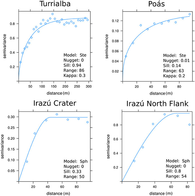
Figure 1. Experimental variogram and fitted variogram model after removing nugget generating points for the CO2 database of each volcano. “Sph” means Spherical model and “Ste” means Matérn model with M. Stein's Parameterization. Kappa is the smoothing parameter of the Matérn model. The x-axis is the inter-distance between the points used to form the couples used to compute the semivariance.
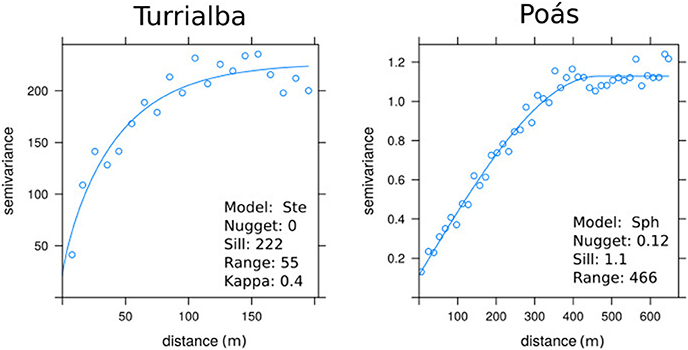
Figure 2. Experimental variogram and fitted variogram model after removing nugget generating points for the 10 cm ground temperature database of Turrialba and Poás. “Sph” means Spherical model and “Ste” means Matérn model with M. Stein's Parameterization. Kappa is the smoothing parameter of the Matérn model. The x-axis is the inter-distance between the points used to form the couples used to compute the semivariance.
The diffuse degassing data for volcanoes is known to be log-normally distributed and to exhibit a frequently overlapping polymodal distribution indicating different degassing sources (Chiodini et al., 1998, 2001; Cardellini et al., 2003). Basically, these sources are generally a background and endogenous sources and the data are assigned to those sources using a graphical statistical approach (Chiodini et al., 1998, 2001; Cardellini et al., 2003). The partitioning of these sources provides important information about the volcano's dynamic and volcanic activity. The unknown parameters that must be determined are the mean, the standard deviation and the contribution to the whole degassing flux of each source. However, they cannot be easily computed when there is a significant overlap of populations (Sinclair, 1974). Thus, these parameters must be computed and the graphical statistical procedure above mentioned involves probability plots according to the Sinclair approach (Sinclair, 1974, 1976). We can thus deduce a generic probability law on which the diffuse CO2 degassing random variable depends. The reliability of the inferred probability law was then tested with a Monte Carlo simulation. A Monte Carlo simulation is a random sampling of a variable according to a determined probability law (Krauth, 2006). In this case, we randomly sampled the same amount of field sample data according to the inferred probability law, and compare the experimental histogram with the simulated Monte Carlo one.
Results
Figures 3–5 show the measurement points and the spatial interpolation using sGs for Turrialba, Poás, and Irazú, respectively. Probability plots for CO2 degassing data are shown in Figure 6 and ground temperature ones are shown in Figure 7. Poás volcano ground temperature plot probably does not account for volcanic phenomena because the mean values are close to one another and all below 20°C. So we assume that the temperature populations for Poás are more likely to be caused by daily meteoric and/or environmental effects. CO2 and temperature data are log-normally distributed and exhibit clear poly-modal distribution. Partitioning of probability plots was performed using the Sinclair methodology (Sinclair, 1974, 1976). Population parameters are summarized in Table 1 and total gas budgets are summarized in Table 2. Additionally, in order to check the accuracy of our mathematic model, a Monte Carlo simulation was performed according to the inferred probability law. The data histogram and Monte Carlo simulation for both CO2 degassing and ground temperature data are shown in Figures 6, 7, respectively.
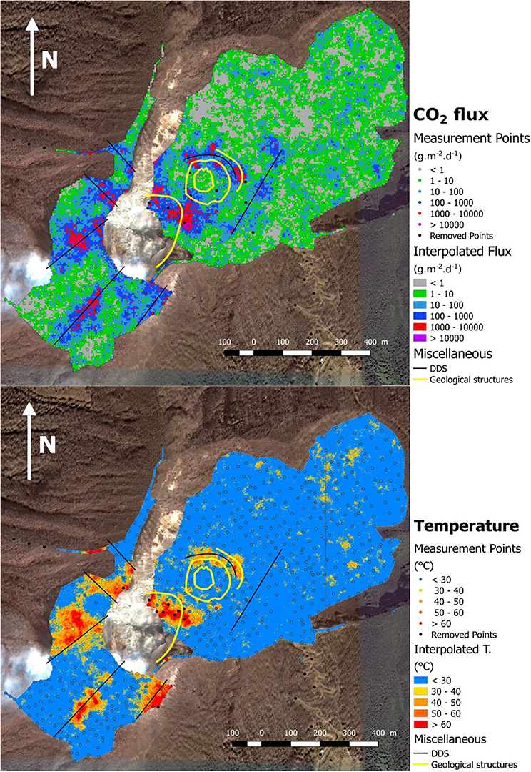
Figure 3. Summit area of Turrialba volcano: measurement points and interpolation by sGs method of CO2 flux with 5 × 5 m of resolution and ground temperature at 10 cm depth with 1 × 1 m resolution over a satellite photography. Both interpolations made on the basis of 5,000 sGs. The yellow circles represent the central crater, and the yellow line at the west of the east crater represents an area which collapsed during an eruptive event in late 2014. DDS is Diffuse Degassing Structures.
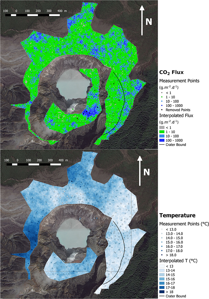
Figure 4. Poás volcano main crater: measurement points and interpolation by sGs method of CO2 flux and ground temperature at 10 cm depth with, respectively, 5 × 5 and 1 × 1 meters resolution over a satellite photography. Both interpolations made on the basis of 10,000 sGs.
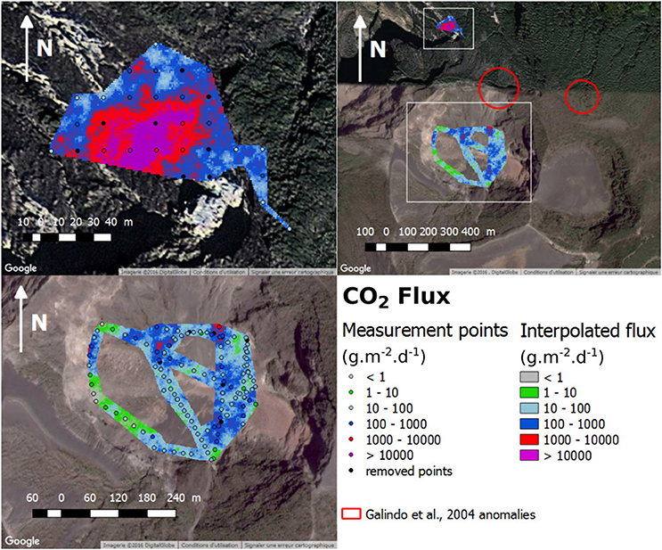
Figure 5. Irazú volcano: measurement points and interpolation by sGs method of CO2 flux with 1 × 1 meter resolution over a satellite photography for Irazú's main crater and Irazú's north flank. Both interpolations made on the basis of 15,000 sGs. Data from both fluxmeters.
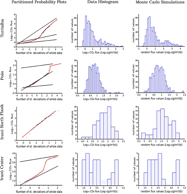
Figure 6. Partitioned probability plots, histogram of data and Monte Carlo simulation for CO2 diffuse degassing data for each volcano. The straight lines in probability plots column represent the populations inferred from partitioning the data. The red curve represent the probability model which best fits the data. Monte Carlo simulation (third column) where established by sampling the same amount of random data than field data, but according to the inferred probability law.
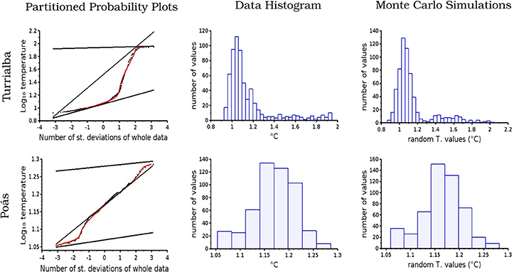
Figure 7. Partitioned probability plots, histogram of data and Monte Carlo simulation for 10 cm ground temperature data for Turrialba and Poás. The straight lines in probability plots column represent the populations inferred from partitioning the data. The red curve represent the probability model which best fits the data. Monte Carlo simulation (third column) where established by sampling the same amount of random data than field data, but according to the inferred probability law.
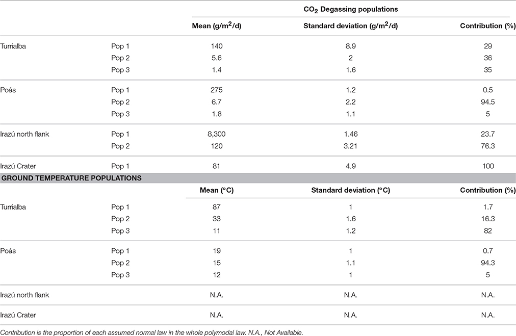
Table 1. Summary table showing the parameters of the different computed populations for CO2 flux and ground temperature for each volcano.
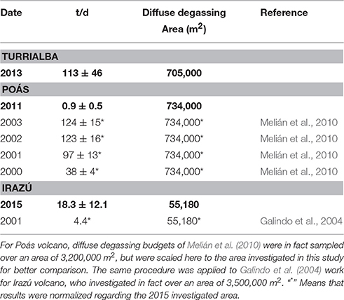
Table 2. Comparative table summarizing total diffuse CO2 budget measured in this study (in bold) and comparing with past and contemporary results of diffuse degassing studies.
The spatial interpolation of CO2 degassing data and the summing of all raster cells allowed us to compute the total CO2 diffuse degassing flux. The computation of carbon flux caused by the background was computed on the basis of probability plots (Figure 6) and removed from the total flux. Indeed, populations lower than 20–30 g/m2/d could be explained by biological activity (Chiodini et al., 2010) and should be removed from the database in order to get the endogenous flux only. In the case of Poás, the dome area was excluded from this investigation because it is an active degassing area (Fischer et al., 2015; de Moor et al., 2016b). Hence, the total endogenous flux for Turrialba volcano was computed as 113 ± 46 tons/d on the basis of 5,000 simulations and after withdrawing the flux caused by Pop 2 and 3 (Table 1). Poás was computed as 0.9 ± 0.5 tons/d on the basis of 10,000 simulations and after removing the flux caused by Pop 2 and 3 (Table 1). Irazú's main crater was computed as 3.8 ± 0.89 tons/d and Irazú's north flank was computed as 15 tons/d ± 12 tons/day both on the basis of 15,000 simulations. The computation of the background was not possible in the case of Irazú. First, the mean of each population (Table 1) are not relevant with typical background values (Chiodini et al., 2010). Secondly, the investigated area was targeted at the high degassing area, which are small. Hence, the background was not sampled. Uncertainties are two standard deviation intervals around the mean containing 95.4% of the statistical computed fluxes. In the case of Irazú, Diego de la Haya crater, Playa Hermosa, and the SW summit were also investigated. The south-western area shows evidence of instability with various landslides reported since 2014, but no diffuse CO2 flux was observed neither here nor in the older craters of Diego de la Haya and Playa Hermosa.
Discussion
Poás
Two important observations arise from our data from Poás volcano. First, the total diffuse gas was computed as 0.9 ± 0.5 t/d, which is a comparatively low value. For example, the lowest diffuse CO2 budget found by Melián et al. (2010) was 164 ± 15 t/d in 2,000 over an area of 3,200,000 m2, which leads to a value of 38 ± 4 t/d when scaled to the area investigated in this work (734,000 m2). A comparison of results between this survey and that of Melián et al. (2010) are presented in Table 2. The difference could be partially due to the better spatial resolution of our study which confines each anomaly to a smaller area. But such an explanation may be not sufficient to explain the observed difference. Secondly, the maximum ground temperature value among all measurement points is 19.3°C. By comparison, temperatures up to about 92°C were recorded at 40 cm depth at some locations each year of the 2000–2003 campaigns of Melián et al. (2010). Hence, no thermal anomaly was recorded in 2012. The temperature interpolation shown in Figure 4 supports this observation because no pixel value higher than 20°C is predicted. Assuming, as mentioned above, that the populations found in the temperature probability plot are more likely to represent environmental or meteoric effects rather than authentic volcanic phenomena, temperature decrease is further evidence of a real decrease in diffuse CO2 flux.
This is in agreement with the population flux parameters. The highest population flux was computed up to 275 g/m2/d, but contributes only to 0.5% of the total gas flux (Table 1). In comparison, Melián et al. (2010) found endogenous population between 354 g/m2/d (in 2001) and up to 4,498 g/m2/d (in 2003). Regardless of the investigated area, the Poás degassing populations pattern appears to be quite similar to Melián et al. (2010) results in 2001, suggesting that the volcano was in a similar stage in 2012. It is an indication that the boiling aquifer causing the endogenous flux (Chiodini et al., 2001) was not as active as previous years and was at a quiescent stage. In any case, the few points defining this population are located eastward of the dome traducing the permeability of this area, which was also noticeable in Melián et al. (2010) degassing maps.
In comparison, the dome fumaroles produced 26 ± 11 t/d of CO2 in April 2013 (Aiuppa et al., 2014) and degassing from the acid crater lake produced between ~30 ± 10 T/d in 2014 (de Moor et al., 2016b). The gas flux through the lake is directly correlated with the occurrence of phreatic eruptions, with increased magmatic gas and heat delivery driving explosive activity (de Moor et al., 2016b). Though our diffuse degassing flux estimate of 0.9 ± 0.5 t/d for 2012 is not contemporaneous with existing estimates of active degassing flux (Aiuppa et al., 2014; de Moor et al., 2016b; from measurements 2013 and 2014), we estimate the total gas flux from Poás for this period (2012–2014) to be 56 ± 22 T/d. Diffuse degassing contributes ~10% of the total gas flux.
A very weak gas anomaly to the east of the crater (Figure 4) which is known to be permeable, is also noticeable. Indeed, Melián et al. (2010) detected a strong gas anomaly in this area in 2002, and this area also experienced substantial fumarolic activity (Naranja and Official fumaroles, Fischer et al., 2015). It is however intriguing to note that the Naranja and Official fumaroles disappeared in 2014 and all fumarolic activity was thereafter confined to the dome (Fischer et al., 2015), which is evidence of progressive channelization of dispersed degassing to a more centralized conduit focused at the dome and lake.
Fresh and undegassed magma in the magmatic chamber occurred at a depth of 500 m in late 2000/early 2001, defining a new magmatic cycle (Rymer et al., 2009; Fischer et al., 2015). Assuming that an injection of new magma indeed took place, there are two possibilities to explain our results.
1. Notsu et al. (2006) argue that when magma establishes open conduits to the surface, pressure decreases due to an efficient active degassing, which causes a dramatic decrease of CO2 diffuse degassing. Consequently, Notsu et al. (2006) define five stages of activity characterized by a diffuse vs. active CO2 degassing ratio. Stage 1 is a complete quiescence stage where neither diffuse nor active degassing occurs. When magma is rising, diffuse degassing starts (stage 2) followed by active degassing (stage 3). When magma comes close to the surface, active degassing still increases while diffuse degassing decreases strongly and could become negligible (stage 4). Finally, when magmatic chamber is flushing out, active degassing disappears and an episode of diffuse degassing may occur once again (stage 5). Observations at Poás have shown an increase in diffuse CO2 degassing from 2000 to 2003 (Melián et al., 2010; see Table 2). By 2012, diffuse degassing had decreased to 0.9 ± 0.5 t/d. By linking these observations, we propose that Poás was at increased diffuse degassing stage (stage 2 in Notsu et al., 2006) in 2000, at increased active channelized degassing stage (stage 3) between 2001 and 2003, and at active channelized degassing only stage (stage 4) in 2011. In April 2017 Poás produced its first phreatomagmatic eruption in over 50 years.
2. Fischer et al. (2015), through intermittent geochemical monitoring of the different fumarole between 2001 and 2014 (including currently inactive Naranja and Official fumaroles) argue that all phreatic eruptions which occurred from 2006 until the present were caused by the periodic pattern sealing, pressure increase, hydrofracturing, phreatic eruption, water infiltration and cooling generated by the 2000–2001 magmatic intrusion. The weak diffuse budget and the fact that Naranja and Official fumaroles became inactive in 2014 may be explained if the volcano was in a sealing-pressure increase stage, probably associated with increased channelization of gases to the central conduits at the dome and lake.
Turrialba
The primary observation at Turrialba is that the diffuse degassing map is in strong agreement with the ground temperature map. Secondly, we observe a strong diffuse CO2 gas anomaly concentrated around the West Crater, particularly on its east flank near the Central Crater where a vent opened in 2012. On October 29th 2014, a powerful explosion was accompanied by the partial collapse of the crater wall along a structure priorly associated with strong diffuse degassing (Figure 3) to form the 2016 crater, suggesting that the diffuse gas emissions were demonstrating a deep degassing structure. Gas anomalies were also noticeable along SW-NE parallel lineations defining the crater graben and passing through the south of the West Crater and the Central Crater (Figure 3). These orientations have already previously been described by structural geologists (Montero, 2003). Active fumaroles at near boiling temperature were also observable along this lineation. Gas anomalies further correspond with the rim of some old craters, as for example the central crater. In contrast, no anomaly is observed toward the East Crater and a reactivation in this area appears very unlikely.
The same method as for Poás can be applied for Turrialba to estimate the proportion of diffuse degassing in the total CO2 flux, adding the 113 ± 46 t/d diffuse flux to the 1094 ± 631 t/d of active flux measured in 2013 by Aiuppa et al. (2014), one and a half years before the volcanic activity increased. The diffuse emission would then represent between 4 and 22% of the total flux. Such a proportion is comparable with the estimation at Poás volcano.
If Turrialba volcano is following the decreasing pattern described by Notsu et al. (2006), then the 2013 diffuse degassing flux should be lower than the previous years and we could expect that it continued to decrease in the following years. Indeed, Turrialba activity increased and it experienced several vent opening in January 2010 (Campion et al., 2012), in January 2011 and in January 2012 (Alvarado et al., 2016). Furthermore, a new weak ash emission occurred in May 2013 without opening a new vent. These events correspond to the opening of conduits that have been able to channelize some of the diffuse gas (Campion et al., 2012), reducing its contribution to the total flux by transferring it to the active flux instead, particularly in 2011 when those events occurred slightly more frequently. Previous diffuse degassing survey would have been necessary to confirm this theory. However, the occurrence of energetic phreatomagmatic eruption in October 2014, March 2015, May and September 2016 and the increase of CO2 in the plume (Alvarado et al., 2016; de Moor et al., 2016a; Rizzo et al., 2016) comforts the idea that magma established open conduits to the surface.
The endogenous population responsible of the volcanic CO2 flux (Figure 6) comes from the underlying boiling aquifer (Chiodini et al., 2001). However, Campion et al. (2012) have shown that the increasing volcanic activity may have opened dry channels which may feed some vents and fumaroles. Furthermore, this population appears to match well with the highest temperature population which has a mean of 87°C (Figure 3 and Table 1). It is thus not excluded that this population may be composed partly from gases rising directly from the magma. In any cases, most of the points defining this population are located on fractured and/or destabilized areas, traducing variations in permeability of the ground. For example, many high flux points are located near the west crater flank which collapsed in late 2014 (See Figure 3).
Irazú
Due to the difficult nature of the terrain (topography, weather) that limited the number of measurements, and the regularity of the grid, as well as the presence of communication antennas that were strongly interfering with the GPS signal, the results should be viewed with caution. However, the primary observation is that the diffuse gas anomalies are mainly concentrated on the north flank of the volcano, where extensive and intense rock alteration is visible. Gas emanation is present to a lesser extent inside the main crater as shown by measurement points in Figure 5. The rest of the investigated area, i.e., Playa Hermosa, the Diego de la Haya crater and the west flank, where a landslide is occurring, do not present any identified gas anomalies. The north flank has already been noted for its most recent activity with a debris avalanche on December 8th 1994. Initially interpreted as being the result of phreatic eruptions on the flank of the volcano (Barquero et al., 1995), new insight on the data suggests that it was more likely caused by a major landslide (Alvarado et al., 2013). In both of these hypotheses, the presence of diffuse degassing on the north flank implies an ongoing alteration process and hence a modification of the cohesion of the rocks in this steep area that increases the possibility of gravitational instability (López and Williams, 1993).
The diffuse degassing anomaly concentrated on the north flank is consistent with the study conducted in 2001 at Irazú by Galindo et al. (2004). At that time, the Main Crater, was occupied by a lake which disappeared in 2013. The anomalies identified by Galindo et al. (2004) were located to the east of the area investigated in this work, which suggests that the whole north flank is potentially porous and that the site of main degassing has migrated over time. However, those areas were not investigated by our 2015 campaign and we do not know whether those anomalies still exist. A comparison of both the studies is shown in Table 3 and a comparison of the total diffuse CO2 budget in Table 2. Population 1 has a mean of 8,300 gm−2d−1, which is much higher than the Galindo et al. (2004) maximum population. Nevertheless, the diffuse degassing budget in 2001 was of 4.4 t/d [277 t/d over an area of 3,500,000 m2 (Galindo et al., 2004), see Table 2]. This result is very close to the lowest possible diffuse gas flux of our survey, due to the great uncertainty (15 ± 12 t/d). Hence, it is not significant and is not robust evidence of increased degassing. As previously stated, the 2015 campaign, results should be viewed with great caution. First, the 2015 data are severely affected by noise, especially for the north flank. Secondly, Galindo et al. (2004) covered a large area (3.5 km2) with only 201 points. This spatial resolution is not sufficient for seeing local anomalies and (Galindo et al., 2004) may have missed some ones.
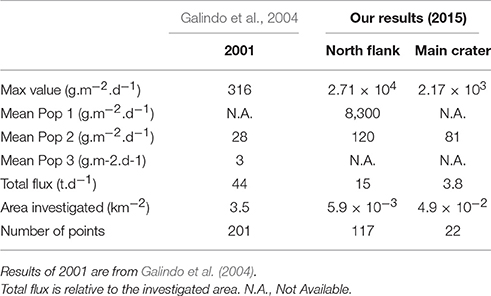
Table 3. Comparative table showing the evolution over time of Irazú volcano.
Finally, the main crater lake disappeared in 2013. One explanation would be that evaporation may have resulted from heat input due to increasing volcanic activity. Such a phenomenon was seen at Poás during an eruptive period: indeed, the acid lake has completely disappeared at the time of writing in response to the ongoing phreatomagmatic activity. Importantly, no CO2 flux anomaly in the crater supports increased volcanic activity as an explanation for the disappearance of the lake at Irazú. The disappearance of Irazú's crater lake is thus more likely to be structural.
The absence of volcanic plume and a weak total diffuse degassing, though with high uncertainty, supports the hypothesis that Irazú volcano is currently in a quiescent stage. Referring's to Notsu et al. (2006) volcanic stages theory, Irazú volcano may be at stage 2. The major hazard currently is collapse events which could generate landslides or lahars. However, our area of investigation is very small and with a high level of uncertainty. In order to allow a better assessment of the volcanic activity, a larger area should be studied.
Conclusion
The investigation of diffuse CO2 degassing allows us to observe the following:
(i) The total diffuse gas budget for Turrialba was computed as 113 ± 46 t/d, 0.9 ± 0.5 t/d for Poás, 3.8 ± 0.9 t/d for Irazú's main crater and 15 ± 12 t/d for Irazú's north flank. However, data from Irazú volcano and especially for the northern flank should be viewed with caution due to the significant amount of noise because of the difficulty of field measurements.
(ii) In both the cases of Poás and Turrialba, diffuse CO2 flux accounts for about 10% of the total volcanic CO2 flux. At the time of diffuse degassing campaigns, both volcanoes were in a transitional stage in dynamic response to recent magma intrusions. The channelizing of gases by conduit opening is responsible for the loss in diffuse degassing and the increase of active degassing (Notsu et al., 2006).
(iii) Structural fluid circulation controls have been observed for Turrialba through diffuse CO2 emission and ground temperature. A strong gas anomaly was observed in 2013 at the east of West Crater (crater wall), which collapsed in 2016. This gas anomaly suggests that the ground has been deeply altered. DDS was also observed on the outer slopes of the west crater, suggesting that the upper outer cone of the volcano has been significantly altered and potentially destabilized. Such tectonic structures, interpreted as an extension of the crater graben, are altered areas which may also experience collapses or may be prone to opening of new vents in the future. No such DDS has been observed at Irazú volcano probably due to the small size of the area investigated, but such structural controls probably exist. The north flank of the volcano is highly porous and may be the source of the main volcanic risk for future flank eruptions. Irazú's crater lake probably disappeared as a result of structural controls, perhaps in response to edifice deformation associated with inflation and activity of the nearby Turrialba volcano (de Moor et al., 2016a).
Our study shows that monitoring of diffuse degassing can be a useful tool for the monitoring of long—to medium-term variations in volcanic activity and associated hazards. Evolution toward more centralized active degassing is associated with increased eruption potential and areas prone to future collapse can in some cases be identified by DDS. Our study calls for more intensive research and monitoring of diffuse and active degassing in order to understand the dynamic volcanic gas budgets.
Author Contributions
ME wrote programs for processing all the data, sampled a part of the Irazu's dataset. He drafted and wrote the different versions of paper. GA sampled the major part of the data (i.e.,) the Turrialba and the Poas dataset. He participate with JdM to the interpretation of the data. He took active part on revising and correcting the paper and approved the final version of the paper. JdM participated to the interpretation of the data. He took also part to the sampling of Irazu's dataset. He also took active part on reviewing the paper and approved the final version to be published. MM took part to the interpretation of the data and contributed to reviewing of the paper. GB participated to the sampling of Poas dataset. HB participated to the sampling of Irazu's dataset.
Conflict of Interest Statement
The authors declare that the research was conducted in the absence of any commercial or financial relationships that could be construed as a potential conflict of interest.
Acknowledgments
We would like to thank Dr. Alastair J. Sinclair for his very constructive and helpful remarks about statistics and programming. We would also like to thank Dr. Melián who kindly accepted to discuss with us in further detail her papers and for having shared with us her experience of Poás. A big thank to Tullio Ricci for his words of advice and his expertise for the interpretation of volcanological data. Thanks also to Dr. C. Werner who provided us useful words of advice during the 5th NOVAC workshop. This work was also supported by Davide Continenza who provided us assistance in the use of the WestSystems fluxmeter.
References
Aiuppa, A., Robidoux, P., Tamburello, G., Conde, V., Galle, B., Avard, G., et al. (2014). Gas measurements from the Costa Rica–Nicaragua volcanic segment suggest possible along-arc variations in volcanic gas chemistry. Earth Planet. Sci. Lett. 407, 134–147. doi: 10.1016/j.epsl.2014.09.041
Allard, P., Carbonelle, J., Dajlevic, D., Le Bronec, J., Morel, P., Robe, M. C., et al. (1991). Eruptive and diffuse emissions of CO2 from Mount Etna. Nature 35, 387–391. doi: 10.1038/351387a0
Alvarado, G. E., Brenes-André, J., Barrantes, M., Vega, E., De Moor, J. M., Avard, G., et al. (2016). La actividad explosiva del volcán Turrialba (Costa Rica) en el período 2010–2016. Rev. Geol. Amér. Central. 55, 7–60. doi: 10.15517/rgac.v55i0.26965
Alvarado, G. E., Mora, M. M., and Ulloa, A. (2013). La caída de “ceniza” proveniente del volcán Irazú (Costa Rica) el 8 de diciembre de 1994: ¿Una explosión freática? Rev. Geol. Am. Central 48, 159–168. doi: 10.15517/rgac.v0i48.12241t
Barberi, F., and Carapezza, M. L. (1994). Helium and CO2 soil gas emission from Santorini (Greece). Bull. Volcanol. 56, 335–342.
Barquero, R., Mora, M., Madrigal, L., Vargas, I., Arias, F., and Soto, G. (1995). Resumen Annual de Sismos y Actividad Volcánica en Costa Rica Durante 1994.- 19 Págs. Oficina de Sismología y Vulcanología, RSN [Inf. Interno].
Bird, R. B., Stewart, W. E., and Lightfoot, E. N. (2001). Transport Phenomena, 2nd Edn. John Wiley & Sons. Available online at: https://www.slideshare.net/Aapandove/bird-stewart-lightfoot-2002-transport-phenomena-2nd-ed
Campion, R., Martinez-Cruz, M., Lecocq, T., Caudron, C., Pacheco, J., Pinardi, G., et al. (2012). Space- and ground-based measurements of sulphur dioxide emissions from Turrialba Volcano (Costa Rica). Bull. Volcanol. 74, 1757–1770. doi: 10.1007/s00445-012-0631-z
Carapezza, M. L., and Granieri, D. (2004). CO2 soil flux at Vulcano (Italy): comparison between active and passive methods. Appl. Geochem. 19, 73–88. doi: 10.1016/S0883-2927(03)00111-2
Carapezza, M. L., Ricci, T., Ranaldi, M., and Tarchini, L. (2009). Active degassing structures of Stromboli and variations in diffuse CO2 output related to the volcanic activity. J. Volcanol. Geotherm. Res. 182, 231–245. doi: 10.1016/j.jvolgeores.2008.08.006
Cardellini, C., Chiodini, G., and Frondini, F. (2003). Application of stochastic simulation to CO2 flux from soil: mapping and quantification of gas release. J. Geophys. Res. 108, 2425. doi: 10.1029/2002JB002165
Chiodini, G., Caliro, S., Cardellini, C., Granieri, D., Avino, R., Baldini, A., et al. (2010). Long-term variations of the Campi Flegrei, Italy, volcanic system as revealed by the monitoring of hydrothermal activity. J. Geophys. Res. 115:B03205. doi: 10.1029/2008JB006258
Chiodini, G., Cioni, R., Guidi, M., Raco, B., and Marini, L. (1998). Soil CO2 flux measurements in volcanic and geothermal areas. Appl. Geochem. 13, 543–552.
Chiodini, G., Frondini, F., and Raco, B. (1996). Diffuse emission of CO2 from the fossa crater, Vulcano Island. Bull. Volcanol. 58, 41–50.
Chiodini, G., Frondini, F., Cardellini, D., Granieri, D., Marini, L., and Ventura, G. (2001). CO2 degassing and energy release at Solfatara volcano, Campi Flegrei, Italy. J. Geophys. Res. 106, 213–221. doi: 10.1029/2001JB000246
de Moor, J. M., Aiuppa, A., Avard, G., Wehrmann, H., Dunbar, N., Muller, C., et al. (2016a). Turmoil at Turrialba Volcano (Costa Rica): Degassing and eruptive processes inferred from high-frequency gas monitoring. J. Geophys. Res. Solid Earth 121, 5761–5775. doi: 10.1002/2016JB013150
de Moor, J. M., Aiuppa, A., Pacheco, J., Avard, G., Kern, C., Liuzzo, M., et al. (2016b). Short-Period volcanic gas precursors to phreatic eruptions: insights from Poás Volcano, Costa Rica. Earth Planet. Sci. Lett. 442, 218–227. doi: 10.1016/j.epsl.2016.02.056
Fischer, T. P., Ramirez, C., Mora-Amador, R. A., Hilton, D. R., Barnes, J. D., Sharp, Z. D., et al. (2015). Temporal variations in fumarole gas chemistry at Poás volcano, Costa Rica. J. Volcanol. Geotherm. Res. 294, 56–70. doi: 10.1016/j.jvolgeores.2015.02.002
Galindo, I., Melián, G. V., Salazar, J. L. M., Hernández, P. A., Pérez, N. M., Ramírez, C., et al. (2004). Emisión difusa de dióxido de carbon en el volcán Irazú, Costa Rica. Rev. Geol. de Am. Central 30, 157–165. doi: 10.15517/rgac.v0i30.7284
Gerlach, T. M. J., and Graeber, E. J. (1985). Volatile budget of Kilauea volcano. Nature 313, 273–277. doi: 10.1038/313273a0
Giammanco, S., Gurrieri, S., and Valenza, M. (1998). Anomalous soil CO2 degassing in relation to faults and eruptive fissures on Mount Etna (Sicily, Italy). Bull. Volcanol. 60, 252–259.
Global Volcanism Program (2006). “Report on Poas (Costa Rica),” in Bulletin of the Global Volcanism Network, 31:3, ed R. Wunderman (Smithsonian Institution).
Global Volcanism Program (2010). “Report on Turrialba (Costa Rica),” in Bulletin of the Global Volcanism Network, 35:2, ed R. Wunderman (Smithsonian Institution).
Global Volcanism Program (2011). “Report on Poas (Costa Rica),” in Bulletin of the Global Volcanism Network, 36:4, ed R. Wunderman (Smithsonian Institution).
Global Volcanism Program (2013). “Report on Poas (Costa Rica),” in Bulletin of the Global Volcanism Network, 38:9, ed R. Wunderman (Smithsonian Institution).
Global Volcanism Program (2015a). “Report on Turrialba (Costa Rica),” in Bulletin of the Global Volcanism Network, 40:4, ed R. Wunderman (Smithsonian Institution).
Global Volcanism Program (2012). “Report on Turrialba (Costa Rica),” in Bulletin of the Global Volcanism Network, 37:6, ed R. Wunderman (Smithsonian Institution).
Global Volcanism Program (2015b). “Report on Poas (Costa Rica), in Bulletin of the Global Volcanism Network, 40:11, ed E. Venzke (Smithsonian Institution).
Hernández Perez, P., Notsu, K., Tsurumi, M., Mori, T., Ohno, M., Shimoike, Y., et al. (2003). Carbon dioxide emissions from soils at Hakkoda, north Japan. J. Geophys. Res. 108, 2210. doi: 10.1029/2002JB001847
Hernández, P. A., Notsu, K., Salazar, J. M., Mori, T., Natale, G., Okada, H., et al. (2001). Carbon dioxide degassing by advective flow from Usu Volcano, Japan. Science 292, 83–86. doi: 10.1126/science.1058450
Hernández, P. A., Perez, N. M., Salazar, J. M., Nakai, S., Notsu, K., and Wakita, H. (1998). Diffuse emission of carbon dioxide, methane, and helium-3 from Teide volcano, Tenerife, Canary Islands. Geophys. Res. Lett. 25, 3311–3314. doi: 10.1029/98GL02561
Krauth, W. (2006). Statistical Mechanics: Algorithms and Computations. Paris: Oxford University Press.
Lewicki, J. L., Bergfeld, D., Cardellini, C., Chiodini, G., Granieri, D., Varley, N., et al. (2005). Comparative soil CO2 flux measurements and geostatistical estimation methods on Masaya volcano, Nicaragua. Bull. Volcanol 68, 76–90. doi: 10.1007/s00445-005-0423-9
López, D. L., and Williams, S. N. (1993). Catastrophic volcanic collapse: relation to hydrother- mal processes. Science 260, 1794–1796. doi: 10.1126/science.260.5115.1794
Martini, F., Tassi, F., Vaselli, O., Del Potro, R., Martinez-Cruz, M., Van del Laat, R., et al. (2010). Geophysical, geochemical and geodetical signals of reawakening at Turrialba volcano (Costa Rica) after almost 150 years of quiescence. J. Volcanol. Geothermal Res. 198, 416–432. doi: 10.1016/j.jvolgeores.2010.09.021
Melián, G. V., Pérez, N. M., Hernández, P. A., Nolasco, D., Marrero, R., Fernández, M., et al. (2010). Emisión difusa de CO2 y actividad volcánica en el volcán Poás, Costa Rica. Rev. Geol. Am. Central 43, 147–170. doi: 10.15517/rgac.v0i43.3462
Melián, G., Galindo, I., Salazar, J., Hernández, P., Pérez, N., Ramirez, C., et al. (2001). “December. Spatial and secular variations of diffuse CO2 degassing from Poas volcano, Costa Rica, Central America,” in AGU Fall Meeting Abstracts (San Francisco, CA), 0951.
Minasny, B., and McBratney, A. B. (2005). The matérn function as a general model for soil variograms, Geoderma 128, 192–207
Montero, W. (2003). El sistema de falla Atirro-Río sucio y la cuenca de tracción de Turrialba-Irazú: indentación tectónica relacionada con la colision del levantamiento del Coco. Geol. Am. Central 28, 5–29. doi: 10.15517/rgac.v0i28.7781
Murata, K. J., Dondoli, C., and Saenz, R. (1966). The 1963–65 eruption of Irazú volcano, Costa Rica (the period of March 1963 to October 1964). Bull. Volcanol. 29:763.
Notsu, K., Mori, T., Chanchah Do Vale, S., Kagi, H., and Ito, T. (2006). Monitoring quiescent vol-canoes by diffuse CO2 degassing: case study of Mt. Fuji, Japan. Pure and Appl. Geophys. 163, 825–835. doi: 10.1007/s00024-006-0051-0
Pan, V., Holloway, J. R., and Hervig, R. L. (1991). The pressure and temperature dependence of carbon dioxide solubility in tholeiitic basalt melts. Geochim. Cosmochim. Acta 55, 1587–1595. doi: 10.1016/0016-7037(91)90130-W
Papale, P., Moretti, R., and Barbato, D. (2006). The compositional dependence of the multi-component volatile saturation surface in silicate melts. Chem. Geol. 229, 78–95. doi: 10.1016/j.chemgeo.2006.01.013
Peltier, A., Finizola, A., Douillet, G. A., Brothelande, E., and Garaebiti, E. (2012). Structure of an Active volcano associated with a resurgent block inferred from thermal mapping: the yasur–yenkahe volcanic complex (Vanuatu). J. Volcanol. Geother. Res. 243–244, 59–68. doi: 10.1016/j.jvolgeores.2012.06.022
Rizzo, A. L., Di Piazza, A., de Moor, M., Alvarado, G. E., Avard, G., Carapezza, M. L., et al. (2016). Eruptive activity at Turrialba volcano (Costa Rica): Inferences from 3 He/ 4 He in fumarole gases and chemistry of the products ejected during 2014 and 2015. Geochem. Geophys. Geosyst. 17, 4478–4494. doi: 10.1002/2016GC006525
Rymer, H., Cassidy, J., Locke, C. A., Barboza, M. V., Barquero, J., Brenes, J., et al. (2000). Geophysical studies of the recent 15-year eruptive cycle at Poás Volcano, Costa Rica. J. Volcanol. Geotherm. Res. 97, 425–442. doi: 10.1016/S0377-0273(99)00166-3
Rymer, H., Locke, C. A., Borgia, A., Martínez, M., Brenes, J., Van der Laat, R., et al. (2009). Long-term fluctuations in volcanic activity: implications for future environ-mental impact. Terra Nova 21, 304–309. doi: 10.1111/j.1365-3121.2009.00885.x
Rymer, H., Locke, C. A., Brenes, J., and Williams-Jones, G. (2005). Magma plumbing processes for persistent activity at Poás volcano, Costa Rica. Geophys. Res. Lett. 32:L08307. doi: 10.1029/2004GL022284
Salazar, J. M., Hernández, P. A., Perez, N. M., Melián, G., Alvarez, J., and Notsu, K. (2001). Diffuse emission of carbon dioxide from Cerro Negro volcano, Nicaragua, Central America, Geo-phys. Res. Lett. 28, 4275–4278. doi: 10.1029/2001GL013709
Shimoike, Y., Kazahaya, K., and Shinohara, H. (2002). Soil gas emission of volcanic CO2 at Satsuma-Iwojima Volcano, Japan. Earth Planet. Space 54, 239–247. doi: 10.1186/BF03353023
Sinclair, A. J. (1974). Selection of threshold values in geochemical data using probability graphs. J. Geochem. Explor. 3, 129–149. doi: 10.1016/0375-6742(74)90030-2
Sinclair, A. J. (1976). Applications of Probability Graphs in Mineral Exploration. Vol. 4. Vancouver, BC: Association of Exploration Geochemists. Available on line at: https://www.appliedgeochemists.org/images/stories/Members%20Area/Applications_of_Probability_Graphs_in_Mineral_Exploration.pdf
Stein, M. L. (1999). Interpolation of Spatial Data: Some Theory for Kriging. New York, NY: Springer.
Viveiros, F., Cardellini, C., Ferreira, T., Caliro, S., Chiodini, G., and Silva, C. (2010). Soil CO2 emissions at Furnas volcano. São Miguel Island, Azores archipelago: volcano monitoring perspectives, geomorphologic studies, and land use planning application. J. Geophys. Res. 115, B12208. doi: 10.1029/2010JB007555
Werner, C., and Cardellini, C. (2006). Comparison of carbon dioxide emissions with fluid upflow, chemistry, and geologic structures at the Rotorua geothermal system, New Zealand. Geothermics 35, 221–238. doi: 10.1016/j.geothermics.2006.02.006
Werner, C., Bergfeld, D., Farrar, C. D., Doukas, M. P., Kelly, P. J., and Kern, C. (2014). Decadal-scale variability of diffuse CO2 emissions and seismicity revealed from long-term monitoring (1995-2013) at Mammoth Mountain, California, USA. J. Volcanol. Geotherm. Res. 289, 51–63. doi: 10.1016/j.jvolgeores.2014.10.020
Keywords: CO2, diffuse degassing, gas ratio, Turrialba, Poas, Irazu, gas budget
Citation: Epiard M, Avard G, de Moor JM, Martínez Cruz M, Barrantes Castillo G and Bakkar H (2017) Relationship between Diffuse CO2 Degassing and Volcanic Activity. Case Study of the Poás, Irazú, and Turrialba Volcanoes, Costa Rica. Front. Earth Sci. 5:71. doi: 10.3389/feart.2017.00071
Received: 01 April 2017; Accepted: 23 August 2017;
Published: 11 October 2017.
Edited by:
Benjamin Alexander Black, City College of New York (CUNY), United StatesReviewed by:
Giancarlo Tamburello, Istituto Nazionale di Geofisica e Vulcanologia (INGV), ItalyMarc-Antoine Longpré, Queens College (CUNY), United States
Copyright © 2017 Epiard, Avard, de Moor, Martínez Cruz, Barrantes Castillo and Bakkar. This is an open-access article distributed under the terms of the Creative Commons Attribution License (CC BY). The use, distribution or reproduction in other forums is permitted, provided the original author(s) or licensor are credited and that the original publication in this journal is cited, in accordance with accepted academic practice. No use, distribution or reproduction is permitted which does not comply with these terms.
*Correspondence: Matthieu Epiard, matthieu.epiard@protonmail.com