Mapping a Subsurface Water Channel with X-Band and C-Band Synthetic Aperture Radar at the Iron Age Archaeological Site of ‘Uqdat al-Bakrah (Safah), Oman

 , ,
, , 
 , ,
, , 
Abstract
:1. Introduction
1.1. Context of Research
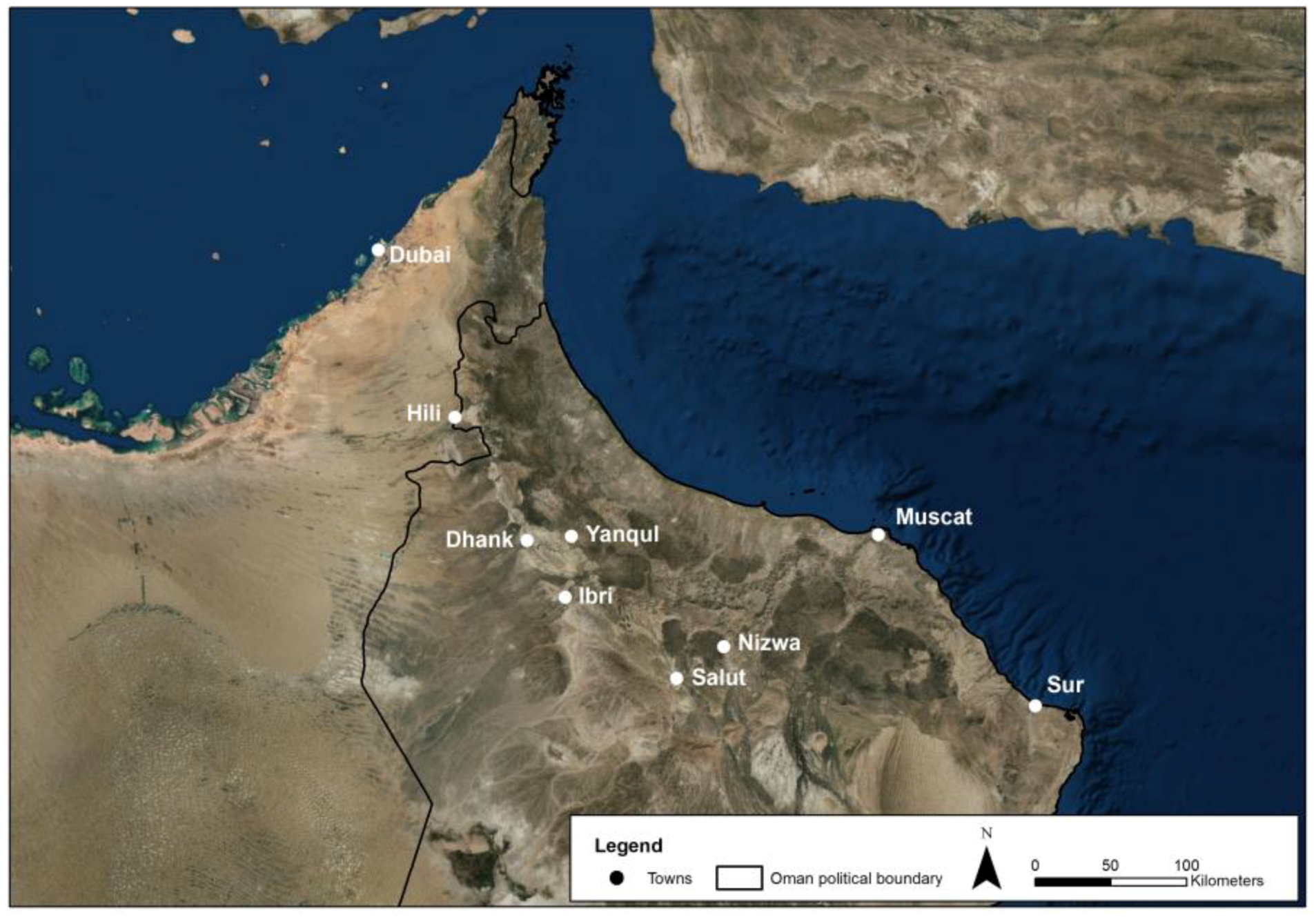
1.2. The Archaeological Site of ‘Uqdat al-Bakrah
2. Materials and Methods
2.1. Data
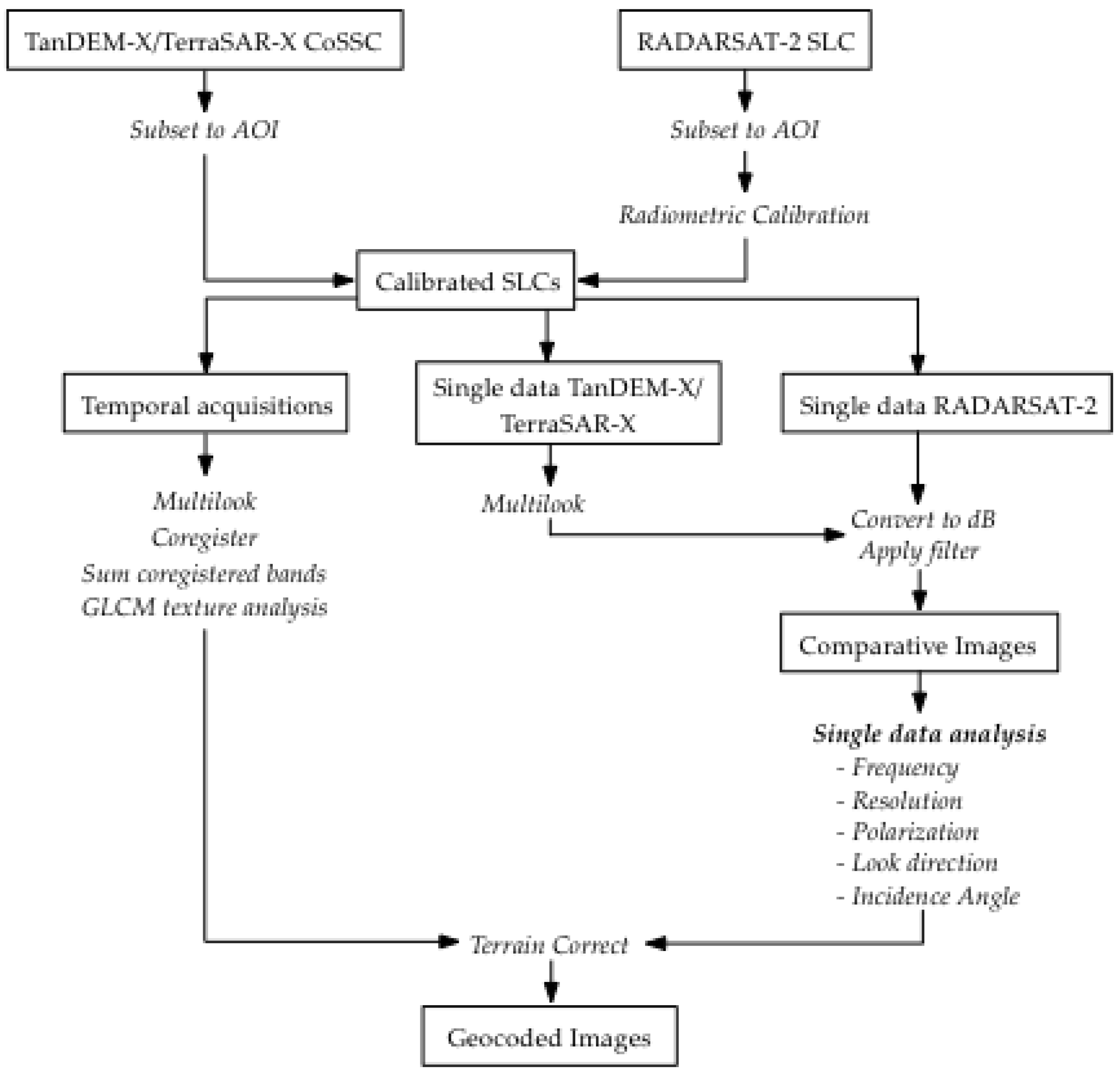
2.2. Processing
3. Results
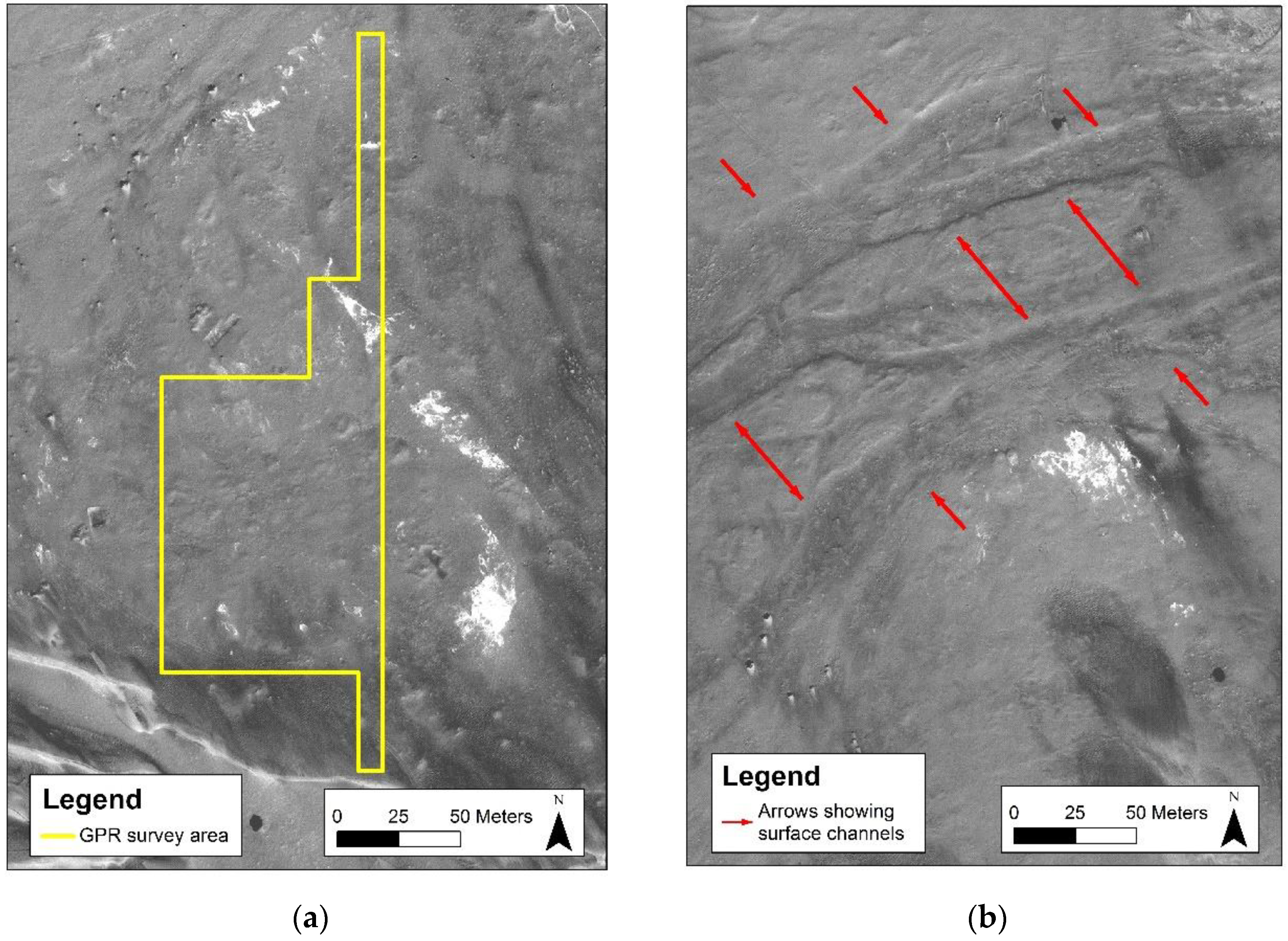
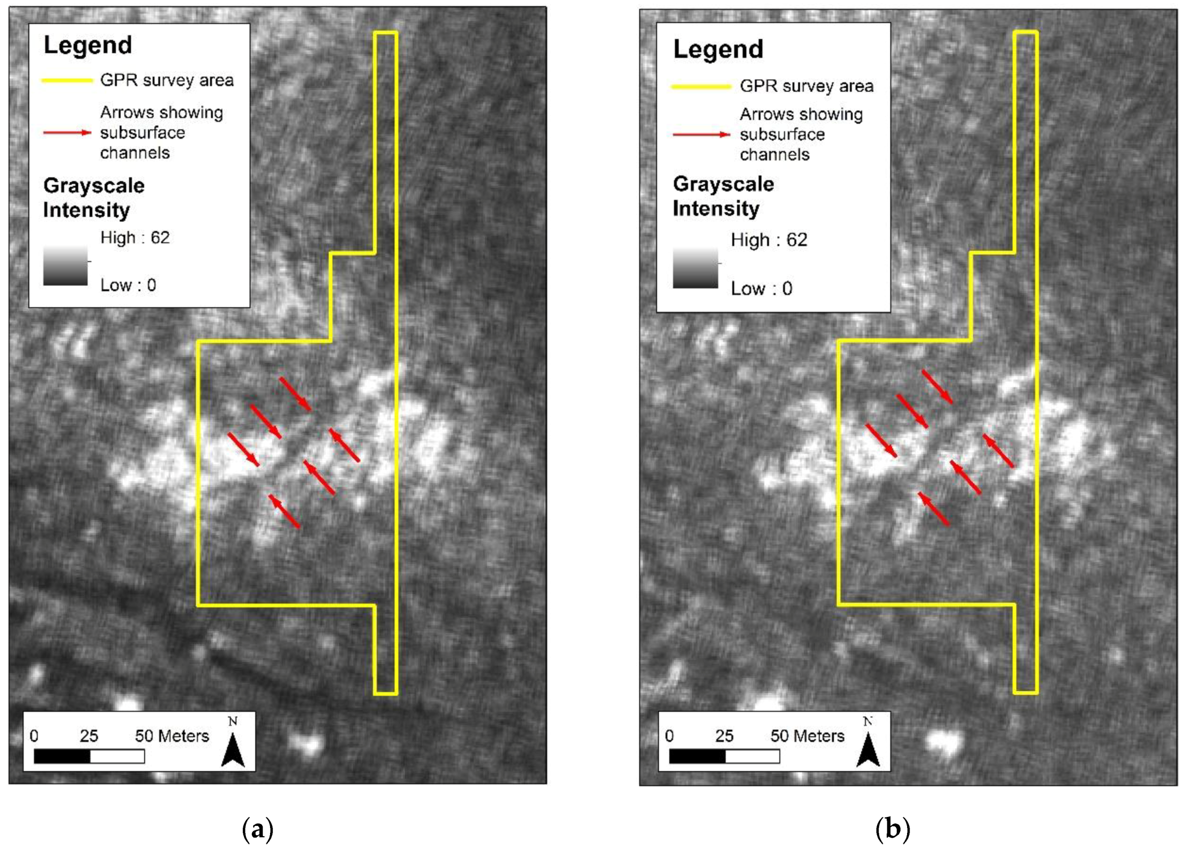
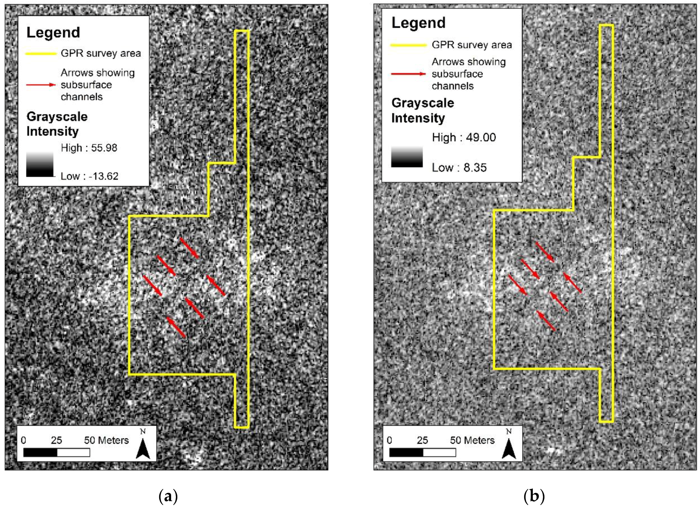
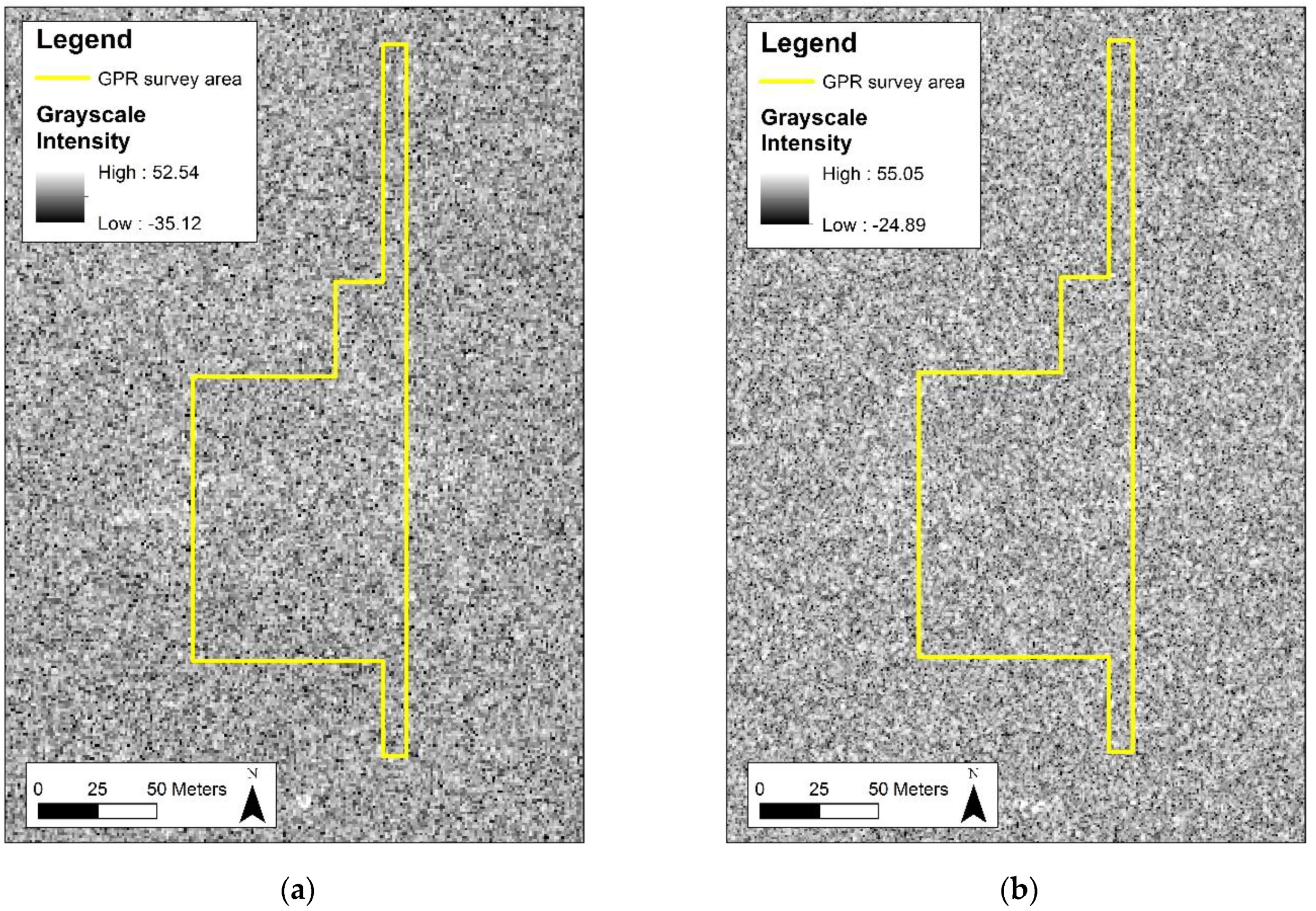
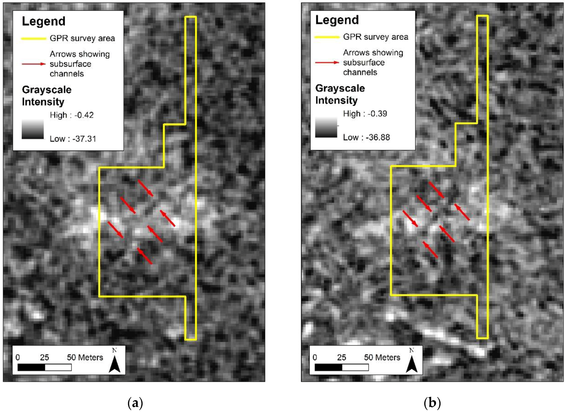
3.1. SAR Analysis and Results
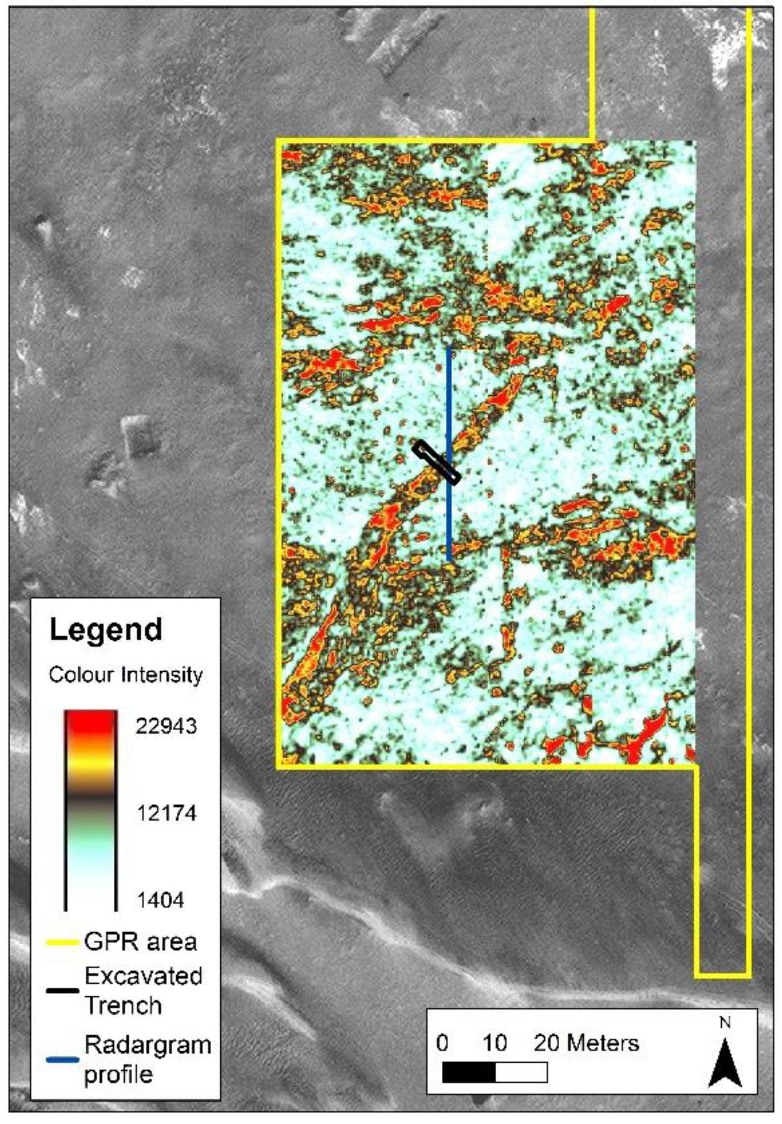
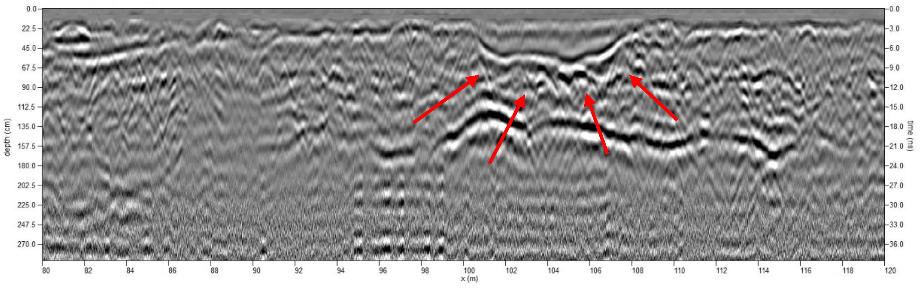
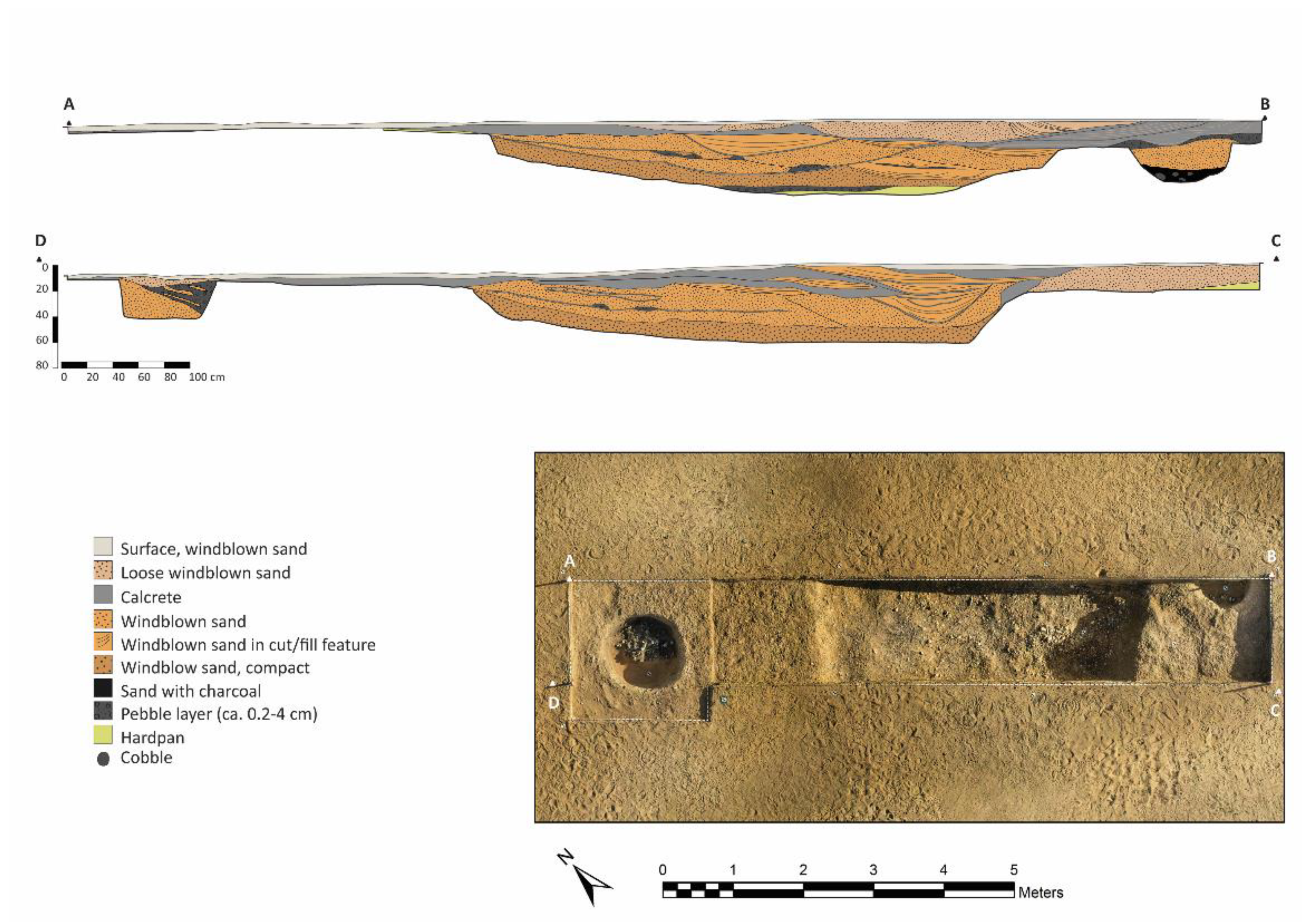
3.2. Ground Verification
4. Discussion
5. Conclusions
Author Contributions
Funding
Acknowledgments
Conflicts of Interest
References
- Adams, R.E.W. Swamps, canals, and the locations of ancient Maya cities. Antiquity 1980, 54, 10. [Google Scholar] [CrossRef]
- Adams, R.E.W.; Brown, W.E.J.; Culbert, P.T. Radar mapping, archaeology and ancient maya land use. Science 1981, 213, 6. [Google Scholar] [CrossRef] [PubMed]
- Adams, R.E.W.; Culbert, P.T.; Brown, W.E.J. News and short contributions: Rebuttal to pope and dahlin. J. Field Archaeol. 1990, 17, 4. [Google Scholar] [CrossRef]
- Pope, K.O.; Dahlin, B.H. Ancient maya wetland agriculture: New insights from ecological and remote sensing research. J. Field Archaeol. 1989, 16, 19. [Google Scholar]
- Elachi, C. Seeing under the sahara: Spaceborne imaging radar. Eng. Sci. 1983, 47, 4–8. [Google Scholar]
- McCauley, J.F.; Schaber, G.G.; Breed, C.S.; Grolier, M.J.; Haynes, C.V.; Issawi, B.; Elachi, C.; Blom, R.G. Subsurface valleys and geoarchaeology of the eastern sahara revealed by shuttle radar. Science 1982, 218, 1004–1020. [Google Scholar] [CrossRef] [PubMed]
- McCauley, J.F.; Breed, C.S.; Schaber, G.G.; McHugh, P.W.; Issawi, B.; Haynes, C.V.; Grolier, M.J.; Kilani, A.E. Paleodrainages of the Eastern Sahara—The radar rivers revisited (SIR-A/B implications for a mid-tertiary trans—African drainage system). IEEE Trans. Geosci. Remote Sens. 1986, 24, 24. [Google Scholar]
- Stewart, C.; Montanaro, R.; Sala, M.; Riccardi, P. Feature extraction in the North Sinai Desert using spaceborne synthetic aperture radar: Potential archaeological applications. Remote Sens. 2016, 8, 825. [Google Scholar] [CrossRef]
- Tapete, D.; Cigna, F. Trends and perspectives of space-borne SAR remote sensing for archaeological landscape and cultural heritage applications. J. Archaeol. Sci. 2017, 14, 11. [Google Scholar] [CrossRef]
- Chen, F.; Lasaponara, R.; Masini, N. An overview of satellite synthetic aperture radar remote sensing in archaeology: From site detection to monitoring. J. Cult. Herit. 2017, 21, 7. [Google Scholar] [CrossRef]
- Lasaponara, R.; Masini, N. Satellite synthetic aperture radar in archaeology and cultural landscape: An overview. Archaeol. Prospect. 2013, 20, 71–78. [Google Scholar] [CrossRef]
- Elachi, C.; Granger, J. Spaceborne imaging radars probein depth. IEEE Spectr. 1982, 19, 24–29. [Google Scholar] [CrossRef]
- Gaber, A.; Koch, M.; Griesh, M.H.; Sato, M.; El-Baz, F. Near-surface imaging of a buried foundation in the Western Desert, Egypt, using space-borne and ground penetrating radar. J. Archaeol. Sci. 2013, 40, 1946–1955. [Google Scholar] [CrossRef]
- Schaber, G.G.; McCauley, J.F.; Breed, C.S.; Olhoeft, G.R. Shuttle imaging radar: Physical controls on signal penetration and subsurface scattering in the Eastern Sahara. IEEE Trans. Geosci. Remote Sens. 1986, 24, 603–623. [Google Scholar] [CrossRef]
- Schaber, G.G.; McCauley, J.F.; Breed, C.S. The use of multifrequency and polarimetric SIR-C/X-SAR Data in geologicstudies of Bir Safsaf, Egypt. Remote Sens. Environ. 1997, 59, 337–363. [Google Scholar] [CrossRef]
- Stewart, C.; Lasaponara, R.; Schiavon, G. ALOS PALSAR nalysis of the Archaeological Site of Pelusium. Archaeol. Prospect. 2013, 20, 109–116. [Google Scholar] [CrossRef]
- Chen, F.; Masini, N.; Liu, J.; You, J.; Lasaponara, R. Multi-frequency satellite radar imaging of cultural heritage: the case studies of the Yumen Frontier Pass and Niya ruins in the Western Regions of the Silk Road Corridor. Int. J. Digit. Earth 2016, 9, 19. [Google Scholar] [CrossRef]
- Paillou, P. Mapping paleohydrography in deserts: Contributions from space-borneimaging radar. Water 2017, 9, 194. [Google Scholar] [CrossRef]
- Patruno, J.; Dore, N.; Crespi, M.; Pottier, E. Polarimetric multifrequency and multi-incidence SAR sensors analyis for archaeological purposes. Archaeol. Prospect. 2013, 20, 89–96. [Google Scholar] [CrossRef]
- Linck, R.; Busche, T.; Buckreuss, S.; Fassbinder, J.W.E.; Seren, S. Possibilities of archaeological prospection by high-resolution X-band Satellite Radar—A case study from Syria. Archaeol. Prospect. 2013, 20, 97–108. [Google Scholar] [CrossRef]
- Linck, R.; Busche, T.; Buckreuss, S. Possibilities of TerraSAR-X Data for the Prospection of Archaeological Sites by SAR. In Proceedings of the 5th TerraSAR-X/4th TanDEM-X Science Team Meeting, Oberpfaffenhofen, Germany, 10–14 June 2013; German Aerospace Centre (DLR): Oberpfaffenhofen, Germany, 2013; p. 4. [Google Scholar]
- Tapete, D. Remote sensing and geosciences for archaeology. Geosciences 2018, 8, 41. [Google Scholar] [CrossRef]
- Kwarteng, A.Y.; Dorvlo, A.S.; Kumar, G.T.V. Analysis of a 27-year rainfall data (1977–2003) in the Sultanate of Oman. Inter. J. Climatol. 2009, 29, 13. [Google Scholar] [CrossRef]
- Yule, P.A.; Gernez, G. Early Iron Age Metal-Working Workshop in the Empty Quarter, al-Zahira Province, Sultanate of Oman; Habelt-Verlag: Bonn, Germany, 2018. [Google Scholar]
- Genchi, F.; Giardino, C. The field work. In Early Iron Age Metal-Working Workshop in the Empty Quarter, al-Zahira Province, Sultanate of Oman; Yule, P.A., Gernez, G., Eds.; Habelt-Verlag: Bonn, Germany, 2018; pp. 11–31. [Google Scholar]
- Harrower, M.J.; Dumitru, I.A.; Wiig, F.; David-Cuny, H.; Taylor, S.P.; Sivitskis, A.J.; Simon, K.M.; Sturm, J.O.; Mazzariello, J.C.; Lehner, J.W.; et al. Archaeological Water Histories of Oman (ArWHO) Project; Field Report for the Ministry of Heritage and Culture; Sultanate of Oman: Muscat, Oman, 2017; p. 151. [Google Scholar]
- Sonnemann, T.F. Spatial configurations of water management at an early angkorian capital—combining GPR and TerraSAR-X data complement an archaeological map. Archaeol. Prospect. 2015, 22, 11. [Google Scholar] [CrossRef]
- Weeks, L.; Cable, C.; Franke, K.; Newton, C.; Karacic, S.; Roberts, J.; Stepanov, I.; David-Cuny, H.; Price, D.; Bukhash, R.M.; et al. Recent archaeological research at Saruq al-Hadid, Dubai, UAE. Arab. Archaeol. Epigr. 2017, 28, 30. [Google Scholar] [CrossRef]
- ESA. SNAP_ESA Sentinel Application Platform Help; Eurpoean Space Agency: Paris, France, 2018. [Google Scholar]
- Institute, R.S.T. TanDEM-X Payload Ground Segment: CoSSC Generation and Interferometric Considerations; German Aerospace Centre (DLR): Cologne, German, 2012; p. 31. [Google Scholar]
- Farr, T.G.; Rosen, P.A.; Caro, E.; Crippen, R.; Duren, R.; Hensley, S.; Kobrick, M.; Paller, M.; Rodriguez, E.; Roth, L.E.; et al. The shuttle radar topography mission. Rev. Geophys. 2007, 45, 33. [Google Scholar] [CrossRef]
- Haralick, R.M.; Shanmugam, K.; Its’Hak, D. Textural features for image classification. IEEE Trans. Syst. Man Cybern. 1973, SMC-3, 21. [Google Scholar] [CrossRef]
- Digital Globe. Accuracy of WorldView Products; Digital Globe: Westminster, CO, USA, 2016; p. 11. [Google Scholar]
- O’Grady, D.; LeBlanc, M.; Gillieson, D. Relationship of local incidence angle with satellite radar backscatter for different surface conditions. Inter. J. Appl. Earth Obs. Geoinf. 2013, 24, 12. [Google Scholar] [CrossRef]
- Blom, R.G.; Cripper, R.E.; Elachi, C. Detection of subsurface features in SEASAT radar images of Means Valley, Mojave Desert, California. Geology 1984, 12, 346–349. [Google Scholar] [CrossRef]
- Paillou, P.; Grandjean, G.; Baghdadi, N.; Heggy, E.; August-Bernex, T.; Achache, J. Subsurface imaging in South-Central Egypt using low-frequency radar: Bir safsaf revisited. IEEE Trans. Geosci. Remote Sens. 2003, 41, 1672–1684. [Google Scholar] [CrossRef]
- Ghoneim, E.; El-Baz, F. The application of radar topographic data to mapping of a mega-paleodrainage in the Eastern Sahara. J. Arid Environ. 2007, 69, 658–675. [Google Scholar] [CrossRef]
- Paillou, P.; Schuster, M.; Tooth, S.; Farr, T.; Rosenqvist, A.; Lopez, S.; Malezieux, J.-M. Mapping of a major paleodrainage system in eastern Libya using oribital imaging radar: The Kufrah River. Earth Planetary Sci. Lett. 2009, 277, 327–333. [Google Scholar] [CrossRef]
- Robinson, C.A.; El-Baz, F.; Al-Saud, T.S.M.; Jeon, S.B. Use of radar data to delineate paleodrainage leading to the Kufra Oasis in the eastern Sahara. J. Afr. Earth Sci. 2006, 44, 229–240. [Google Scholar] [CrossRef]
- Dabbagh, A.E.; Al-Hinai, K.G.; Asif Khan, M. Detection of sand-covered geologic features in the Arabian peninsula using SIR-C/X-SAR data. Remote Sens. Environ. 1997, 59, 375–382. [Google Scholar] [CrossRef]
- Tapete, D.; Cigna, F.; Masini, N.; Lasaponara, R. Prospection and monitoring of the archaeological heritage of Nasca, Peru, with ENVISAT ASAR. Archaeol. Prospect. 2013, 20, 15. [Google Scholar] [CrossRef]
- Elachi, C.; Roth, L.E.; Schaber, G.G. Spaceborne radar subsurface imaging in hyperarid regions. IEEE Transact. Geosci. Remote Sens. 1984, 22, 383–388. [Google Scholar] [CrossRef]
- Gade, M.; Kohlus, J.; Kost, C. SAR imaging of archaeological sites on intertidal flats in the German Wadden Sea. Geosciences 2017, 7, 105. [Google Scholar] [CrossRef]
- Tapete, D.; Cigna, F.; Donoghue, D.N.M. Looting marks in space-borne SAR imagery: Measuring rates of archaeological looting in Apamea (Syria) with TerraSAR-X Staring Spotlight. Remote Sens. Environ. 2016, 178, 17. [Google Scholar] [CrossRef]


| Image Acquisition Date Range | Incidence Angle at Scene Centre (Degrees) | Number of Scenes | Sensor Mode (Polarization) | Orbit (Ascending or Descending) | Channel Visible in Image |
|---|---|---|---|---|---|
| 15 April and 29 May 2017 | 38–52 | 6 | HV and VH | A and D | No |
| 9 June 25 September and 20 June 2017 | 38 | 3 | HH (× 2), VV | A | Yes |
| 7 May and 14 August 2017 | 39 | 5 | VV | D | Yes |
| 18 May and 25 August 2017 | 39 | 5 | HH | D | Yes |
| 9 June 2017 | 40 | 1 | VV | D | Yes |
| 3 June and 14 June 2017 | 52 | 2 | HH and VV | A | No |
| 13 May and 20 August 2017 | 53 | 5 | VV | D | No |
| 2 May and 9 August 2017 | 53 | 6 | HH | D | No |
| Image Acquisition Date(s) | Incidence Angle at Scene Centre (Degrees) | Number of Scenes | Sensor Mode (Polarization) | Orbit (Ascending or Descending) | Channel Visible in Image |
|---|---|---|---|---|---|
| 17 July 2017 | 39 | 1 | HH | A | No |
| 2 July 2017 | 33 | 1 | HH | D | Yes |
| 30 October 2017 | 33 | 1 | VV | D | Yes |
| 14 April and 8 May 2017 | 27 | 2 | HH | D | No |
| 26 April 2017 | 27 | 1 | HH | A | No |
| 16 November 2017 | 27 | 1 | VV | D | Yes |
| Sensor | Acquisition Date | Resolution |
|---|---|---|
| SRTM | February 2000 | 30 m |
| Worldview-3 | 22 April 2016 | 1.2 m multispectral and 0.3 m panchromatic |
© 2018 by the authors. Licensee MDPI, Basel, Switzerland. This article is an open access article distributed under the terms and conditions of the Creative Commons Attribution (CC BY) license (http://creativecommons.org/licenses/by/4.0/).
Share and Cite
Wiig, F.; Harrower, M.J.; Braun, A.; Nathan, S.; Lehner, J.W.; Simon, K.M.; Sturm, J.O.; Trinder, J.; Dumitru, I.A.; Hensley, S.; et al. Mapping a Subsurface Water Channel with X-Band and C-Band Synthetic Aperture Radar at the Iron Age Archaeological Site of ‘Uqdat al-Bakrah (Safah), Oman. Geosciences 2018, 8, 334. https://doi.org/10.3390/geosciences8090334
Wiig F, Harrower MJ, Braun A, Nathan S, Lehner JW, Simon KM, Sturm JO, Trinder J, Dumitru IA, Hensley S, et al. Mapping a Subsurface Water Channel with X-Band and C-Band Synthetic Aperture Radar at the Iron Age Archaeological Site of ‘Uqdat al-Bakrah (Safah), Oman. Geosciences. 2018; 8(9):334. https://doi.org/10.3390/geosciences8090334
Chicago/Turabian StyleWiig, Frances, Michael J. Harrower, Alexander Braun, Smiti Nathan, Joseph W. Lehner, Katie M. Simon, Jennie O. Sturm, John Trinder, Ioana A. Dumitru, Scott Hensley, and et al. 2018. "Mapping a Subsurface Water Channel with X-Band and C-Band Synthetic Aperture Radar at the Iron Age Archaeological Site of ‘Uqdat al-Bakrah (Safah), Oman" Geosciences 8, no. 9: 334. https://doi.org/10.3390/geosciences8090334