Impact of Anthropogenic Facilities on the Morphodynamic Evolution of an Estuarine System: The Case of Oum Er-Rbia Estuary (Azemmour, Morocco)

 , ,
, ,
Abstract
: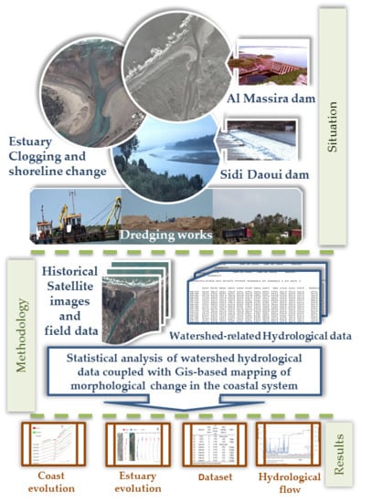
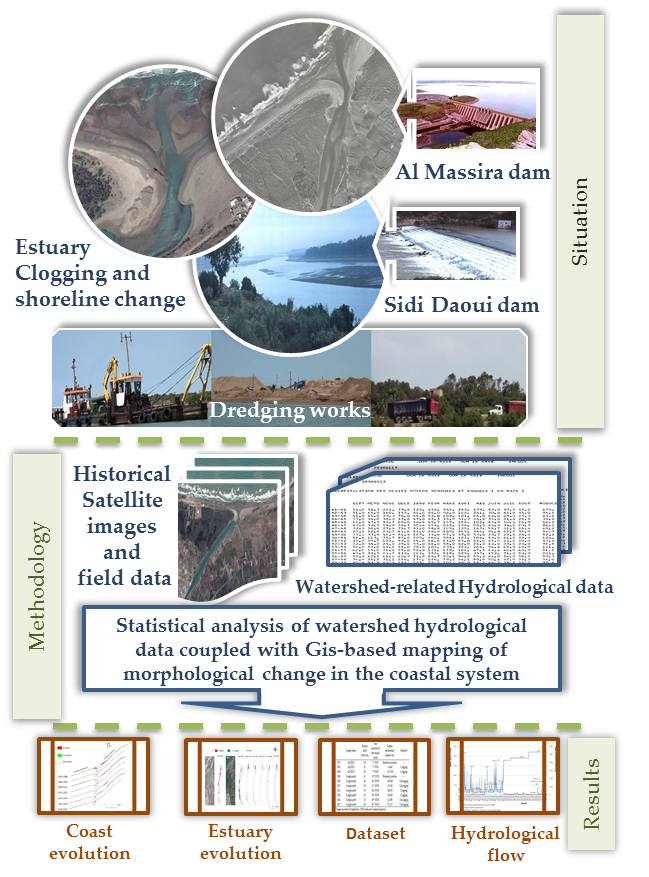
1. Introduction
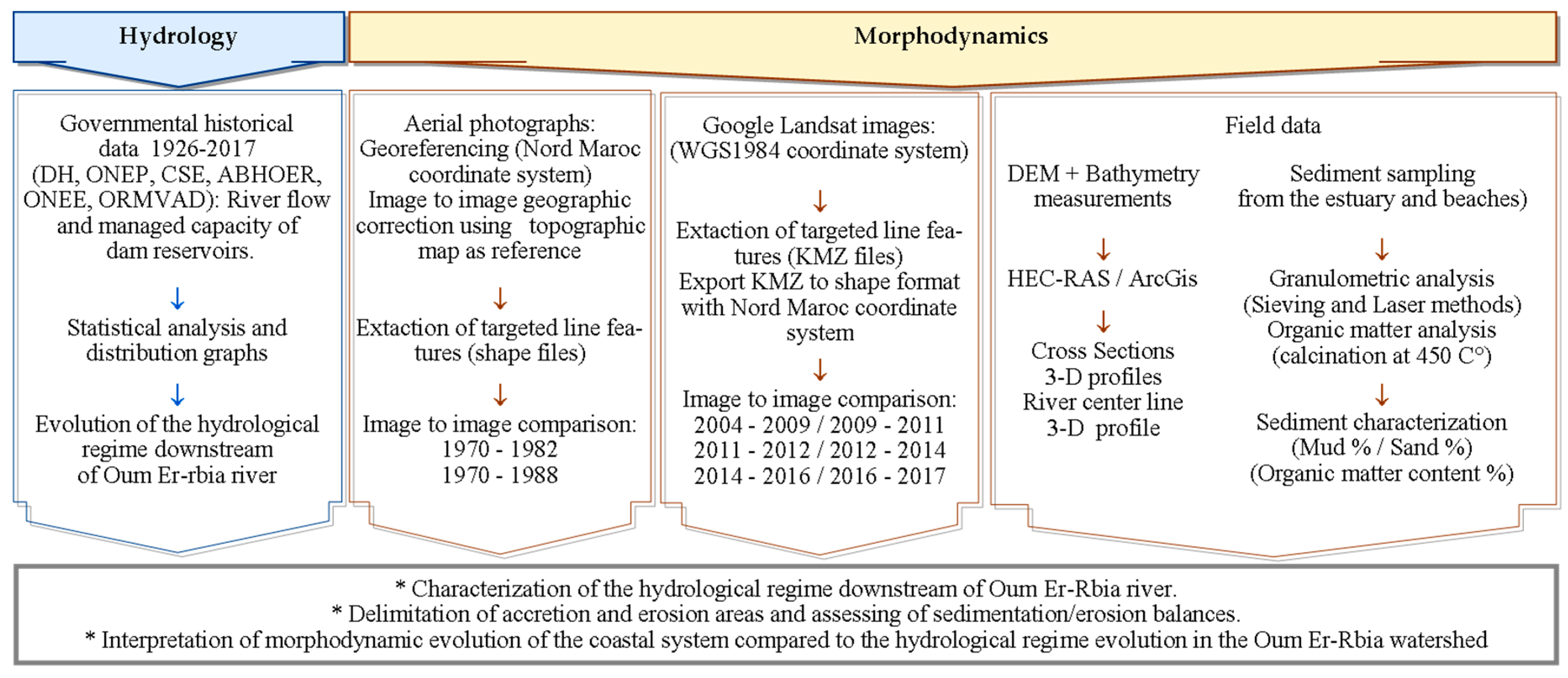
2. Materials and Methods
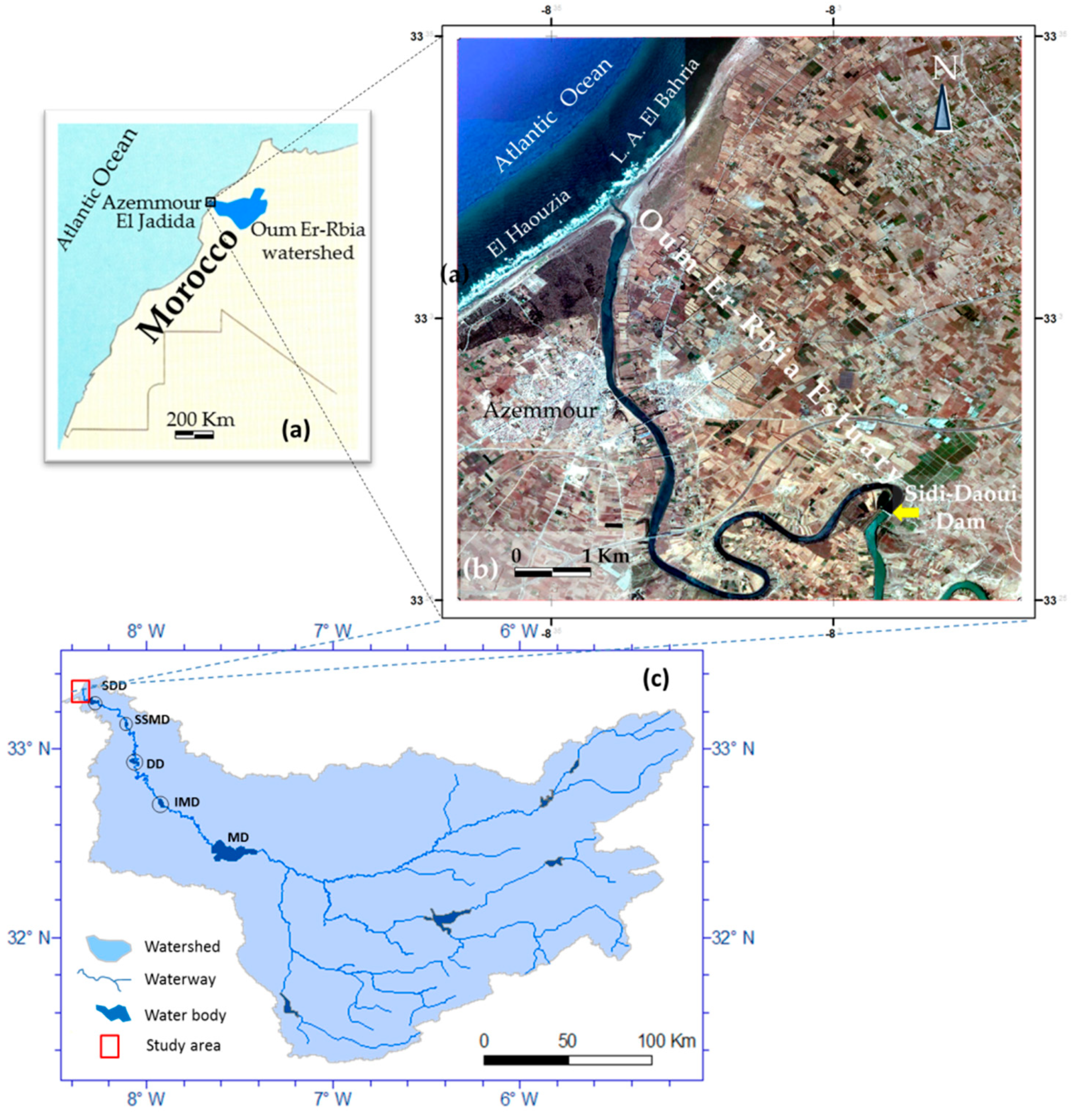
2.1. Study Area
2.2. Data Used
2.3. Methods
3. Results
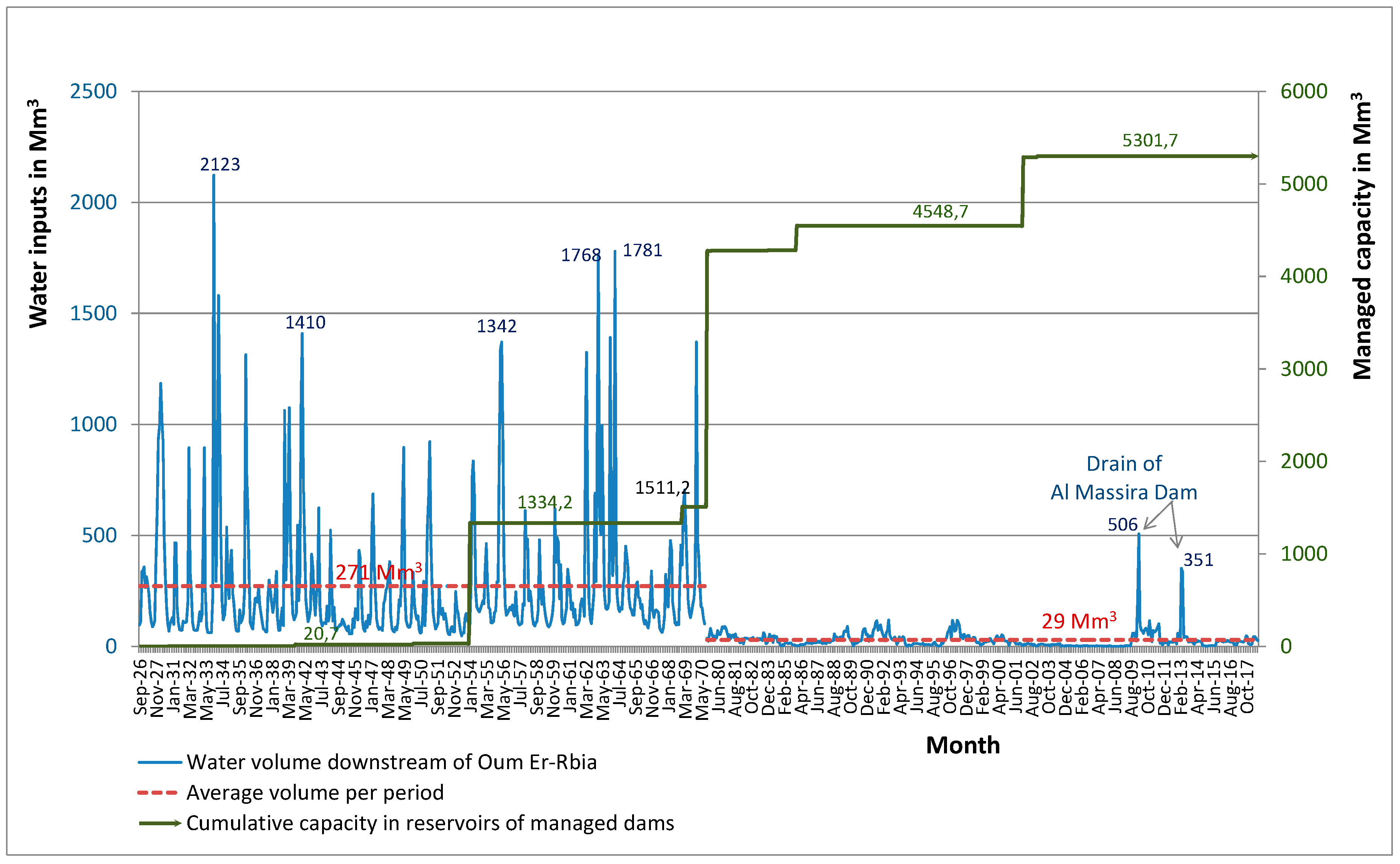
3.1. Hydrologic Evolution of the Oum Er-Rbia River
3.2. Drought Evolution in the Oum Er-Rbia Watershed Area
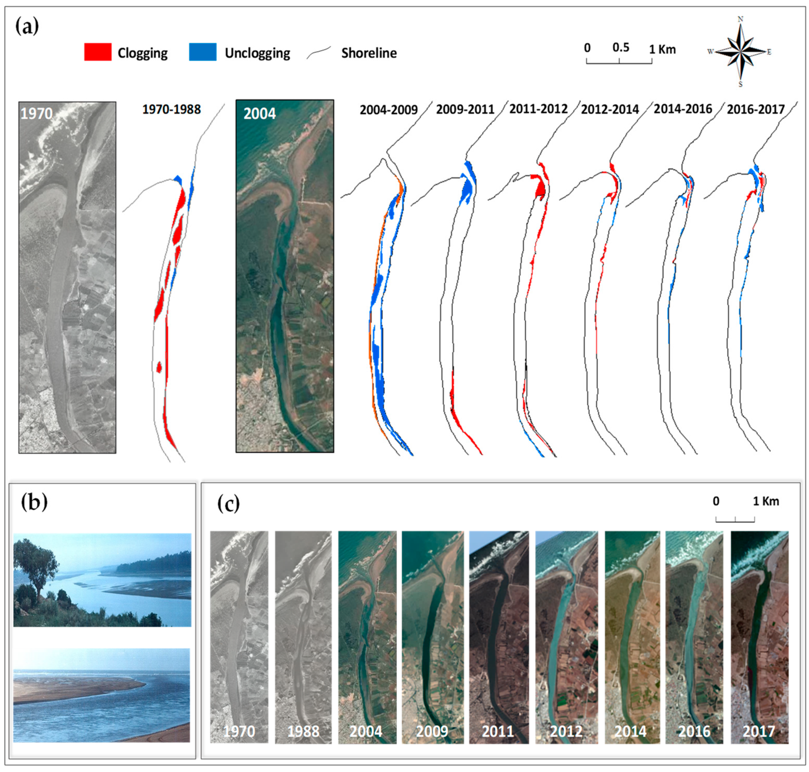
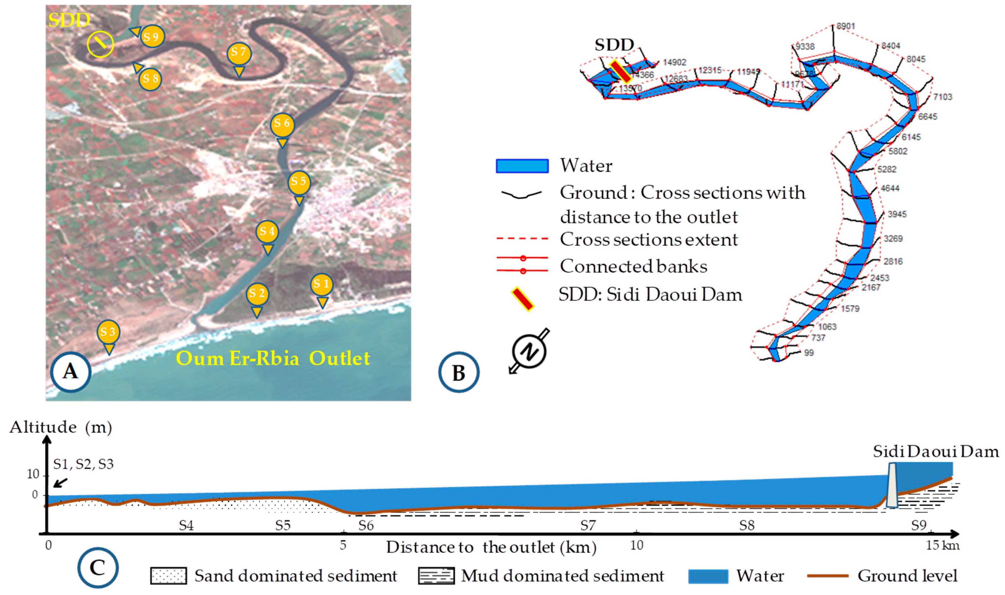
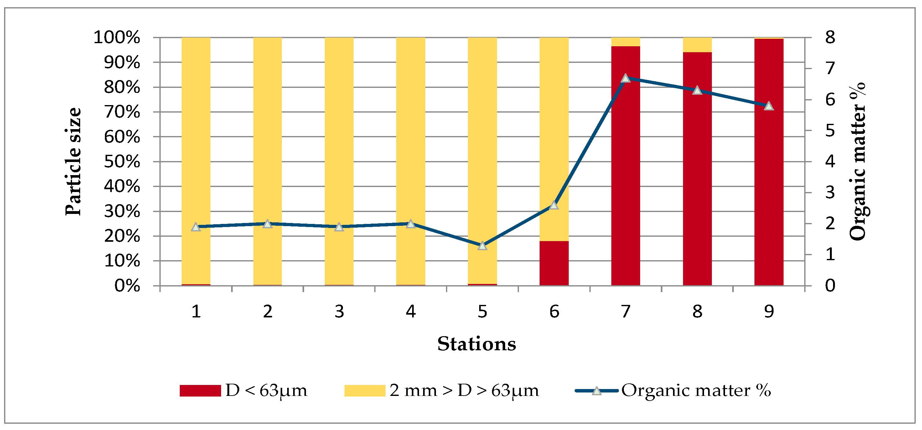
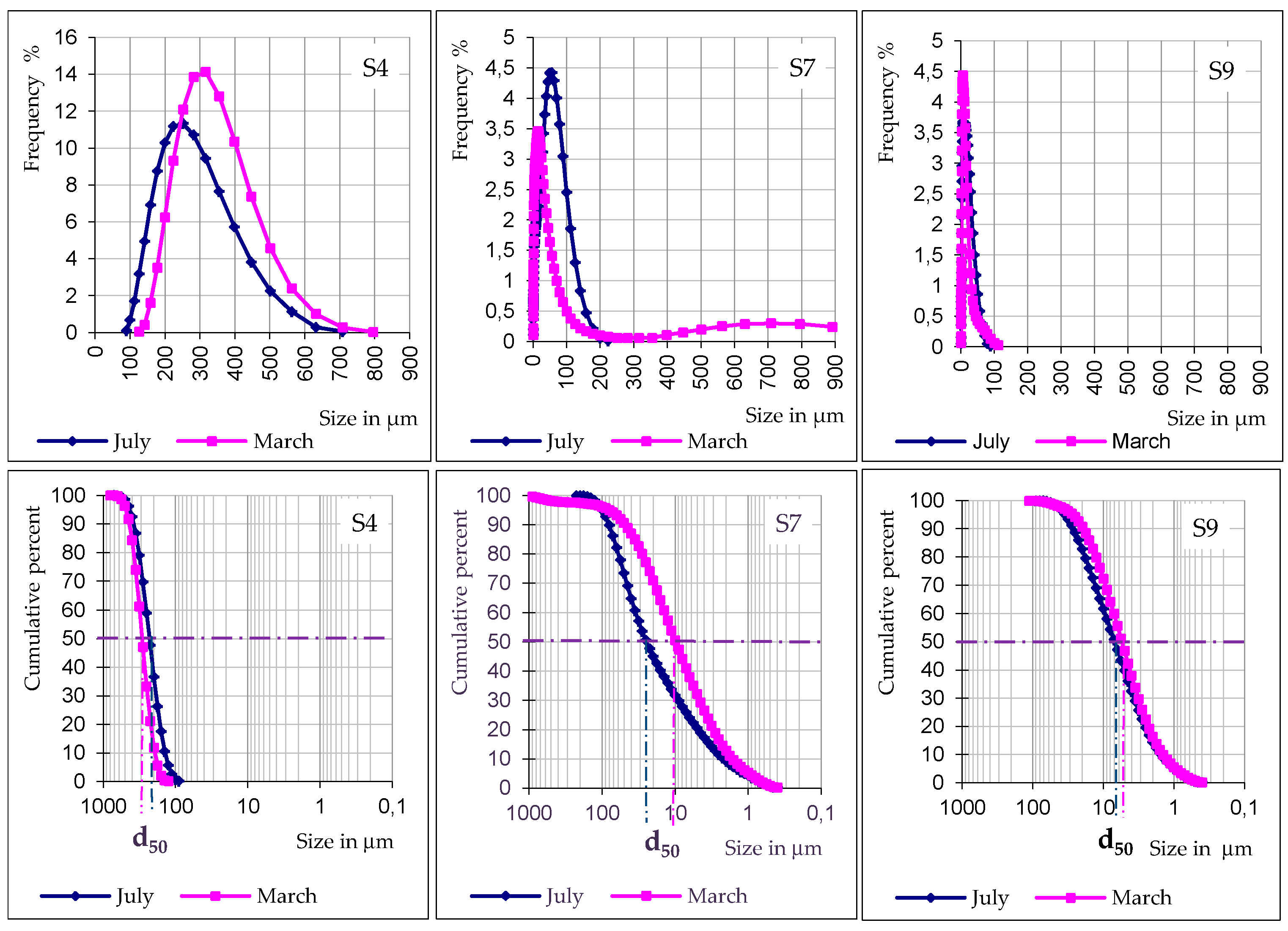
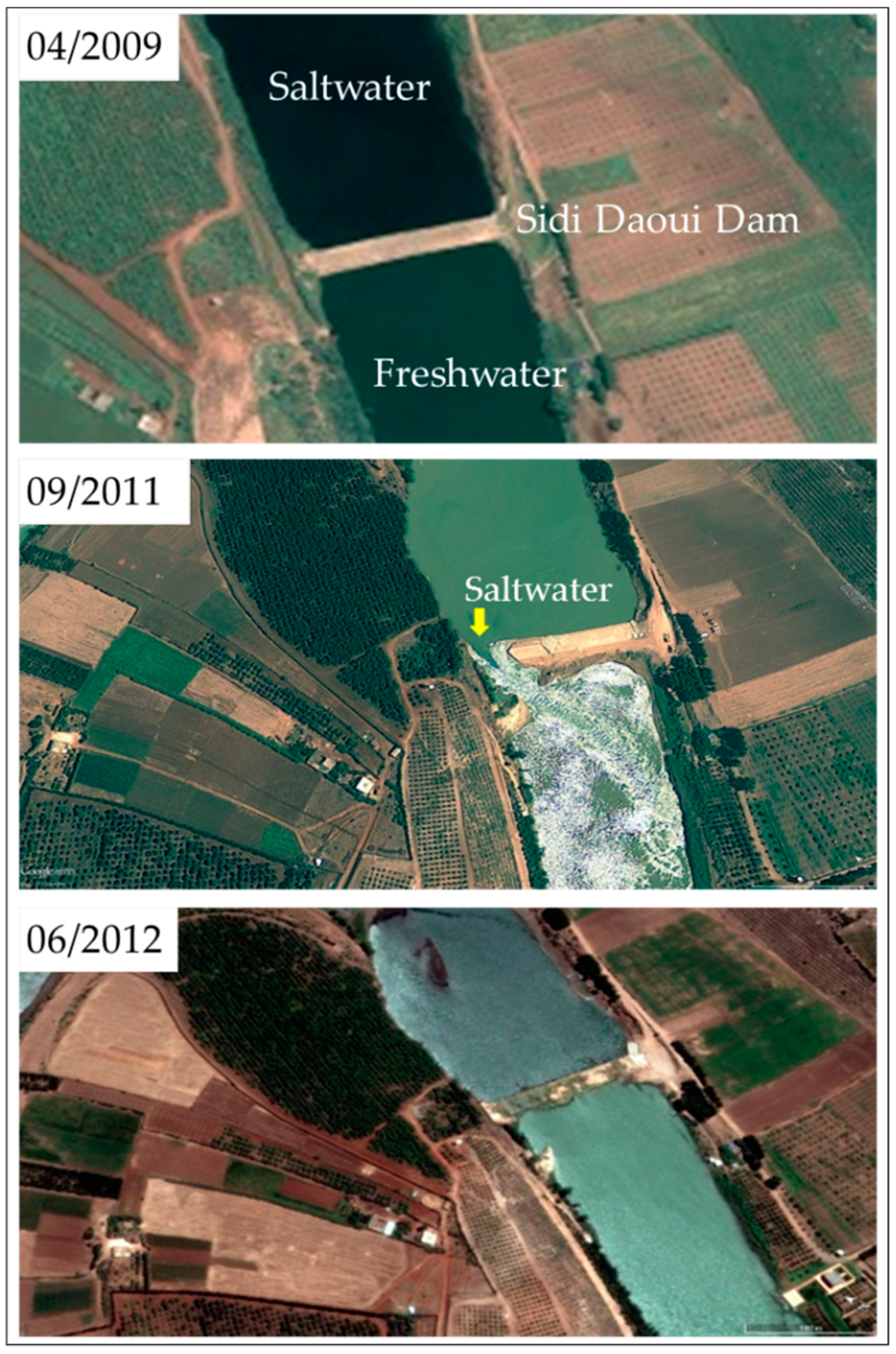
3.3. Morphological Evolution of the Oum Er-Rbia Estuary
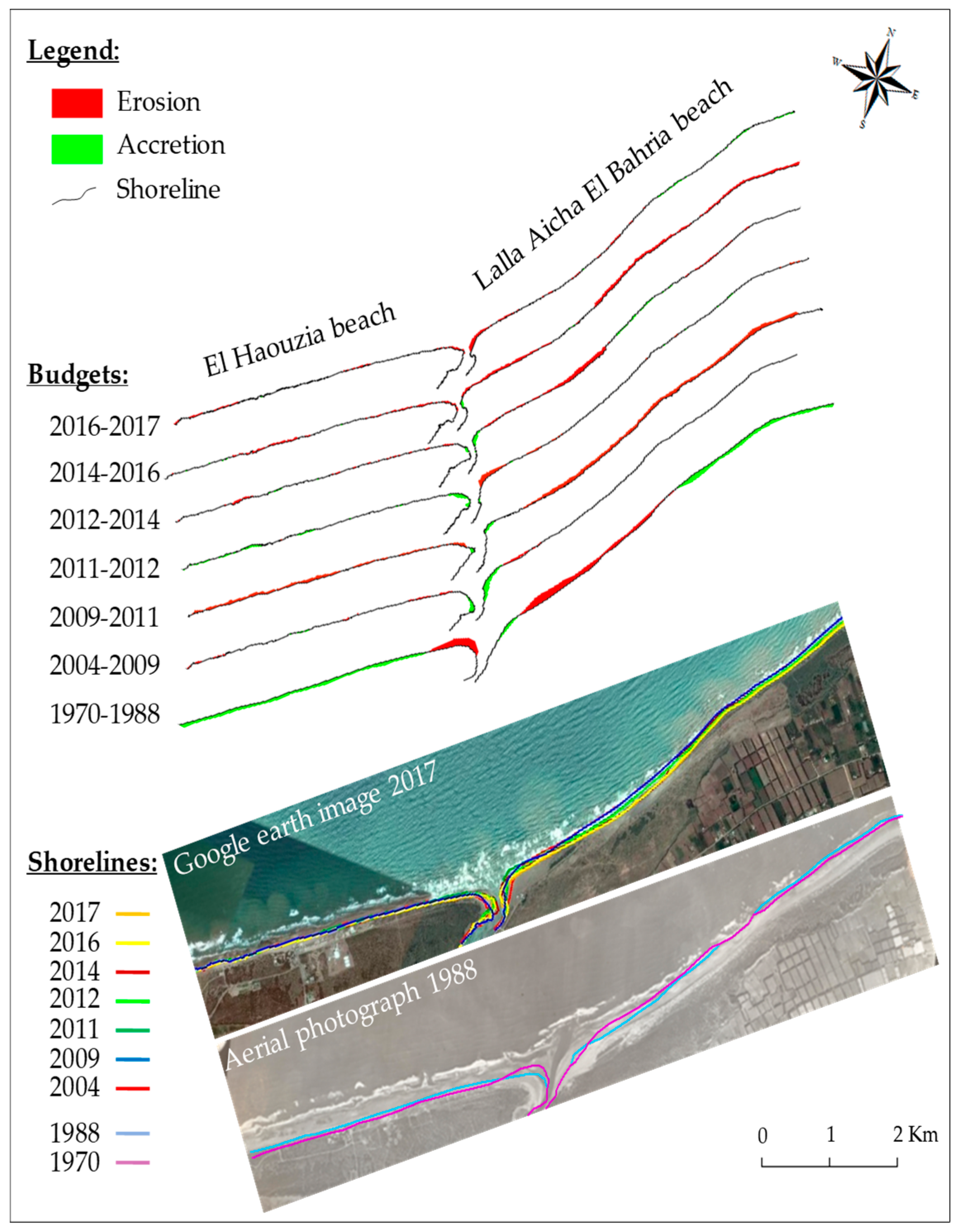
3.4. Morphological Evolution of the Neighboring Beaches
4. Discussion
5. Conclusions
Author Contributions
Funding
Acknowledgments
Conflicts of Interest
References
- Luo, J.; Li, M.; Sun, Z.; O’Connor, B.A. Numerical modelling of hydrodynamics and sand transport in the tide-dominated coastal-to-estuarine region. Mar. Geol. 2013, 342, 14–27. [Google Scholar] [CrossRef] [Green Version]
- Nzualo, T.N.M.; Gallo, M.N.; Vinzon, S.B. Short-term tidal asymmetry inversion in a macrotidal estuary (Beira, Mozambique). Geomorphology 2018, 308, 107–117. [Google Scholar] [CrossRef]
- Dunn, R.J.K.; Zigic, S.; Burling, M.; Lin, H.H. Hydrodynamic and Sediment Modelling within a Macro Tidal Estuary: Port Curtis Estuary, Australia. J. Mar. Sci. Eng. 2015, 3, 720–744. [Google Scholar] [CrossRef] [Green Version]
- Lin, L.; Demirbilek, Z.; Ward, D.; King, D. Wave and Hydrodynamic Modeling for Engineering Design of Jetties at Tangier Island in Chesapeake Bay, USA. J. Mar. Sci. Eng. 2015, 3, 1474–1503. [Google Scholar] [CrossRef] [Green Version]
- Waeles, B.; Le Hir, P.; Lesueur, P.; Delsinne, N. Modelling sand/mud transport and morphodynamics in the Seine river mouth (France): An attempt using a process-based approach (Conference Paper). Hydrobiologia 2007, 588, 69–82. [Google Scholar] [CrossRef]
- Luan, H.L.; Ding, P.X.; Wang, Z.B.; Ge, J.Z. Process-based morphodynamic modeling of the Yangtze Estuary at a decadal timescale: Controls on estuarine evolution and future trends. Geomorphology 2017, 347–364. [Google Scholar] [CrossRef]
- Guo, L.; Wegen, M.; Roelvink, D.; Wang, Z.B.; He, Q. Long-term, process-based morphodynamic modeling of a fluvio-deltaic system, part I: The role of river discharge. Cont. Shelf Res. 2015, 109, 95–111. [Google Scholar] [CrossRef]
- Sampath, D.M.R.; Boski, T. Key parameters of the sediment surface morphodynamics in an estuary: An assessment of model solutions. Geomorphology 2018, 308, 142–160. [Google Scholar] [CrossRef]
- Bergillos, R.J.; Rodríguez-Delgado, C.; Millares, A.; Ortega-Sánchez, M.; Losada, M.A. Impact of river regulation on a Mediterranean delta: Assessment of managed versus unmanaged scenarios. Water Resour. Res. 2016, 52, 5132–5148. [Google Scholar] [CrossRef]
- Bergillos, R.J.; Ortega-Sánchez, M. Assessing and mitigating the landscape effects of river damming on the Guadalfeo River delta, southern Spain. Landsc. Urban Plan. 2017, 165, 117–129. [Google Scholar] [CrossRef]
- Speer, P.E.; Aubrey, D.G. A study of non-linear tidal propagation in shallow inlet/estuarine systems Part II: Theory. Estuar. Coast. Shelf Sci. 1985, 21, 207–224. [Google Scholar] [CrossRef]
- Brown, J.M.; Davies, A.G. Flood/ebb tidal asymmetry in a shallow sandy estuary and the impact on net sand transport. Geomorphology 2010, 114, 431–439. [Google Scholar] [CrossRef]
- Van Rijn, L.C. Principles of Coastal Morphology; Aqua Publications: Amsterdam, The Netherlands, 1998. [Google Scholar]
- Van Rijn, L.C. A simple general expression for long shore transport of sand, gravel and shingle. Coast. Eng. 2014, 90, 23–39. [Google Scholar] [CrossRef]
- Masselink, D.; Puleo, J.A. Swash-zone morphodynamics. Cont. Shelf Res. 2006, 26, 661–680. [Google Scholar] [CrossRef]
- Buscombe, D.; Masselink, G. Concepts in gravel beach dynamics. Earth-Sci. Rev. 2006, 79, 33–52. [Google Scholar] [CrossRef]
- Moore, R.D.; loup, J.; Souza, A.J.; Flint, S.S. Morphological evolution of the Dee Estuary, Eastern Irish Sea, UK: A tidal asymmetry approach. Geomorphology 2009, 103, 588–596. [Google Scholar] [CrossRef] [Green Version]
- Robins, P.E.; Davies, A.G. Morphological controls in sandy estuaries: The influence of tidal flats and bathymetry on sediment transport. Ocean Dyn. 2010, 60, 503–517. [Google Scholar] [CrossRef]
- Luan, H.L.; Ding, P.X.; Wang, Z.B.; Ge, J.Z.; Yang, S.L. Decadal morphological evolution of the Yangtze Estuary in response to river input changes and estuarine engineering projects. Geomorphology 2016, 12–23. [Google Scholar] [CrossRef]
- Wei, W.; Dai, Z.; Mei, X.; Liu, J.P.; Gao, S.; Li, S. Shoal morphodynamics of the Changjiang (Yangtze) estuary: Influences from river damming, estuarine hydraulic engineering and reclamation projects. Mar. Geol. 2017, 386, 32–43. [Google Scholar] [CrossRef]
- Zhu, L.; He, Q.; Shen, J.; Wang, Y. The influence of human activities on morphodynamics and alteration of sediment source and sink in the Changjiang Estuary. Geomorphology 2016, 273, 52–62. [Google Scholar] [CrossRef]
- Wang, Z.B.; Van Maren, D.S.; Ding, P.X.; Yang, S.L.; Van Prooijen, B.C.; De Vet, P.L.M.; Winterwerp, J.C.; De Vriend, H.J.; Stive, M.J.F.; He, Q. Human impacts on morphodynamic thresholds in estuarine systems. Cont. Shelf Res. 2015, 111, 111–174. [Google Scholar] [CrossRef]
- Zhang, W.; Yuan, J.; Han, J.; Huang, C.; Li, M. Impact of the Three Gorges Dam on sediment deposition and erosion in the middle Yangtze River: A case study of the Shashi Reach. Hydrol. Res. 2016, 47, 175–186. [Google Scholar] [CrossRef]
- Snoussi, M.; Jouanneau, J.M.; Latouche, C. Flux de matière issues de bassins versant de zones semi arides (bassin de Sebou et du Souss, Maroc). Importance dans le bilan global des apports d’origine continentale parvenant à l’océan mondial. J. Afr. Earth Sci. 1990, 11, 46–54. [Google Scholar] [CrossRef]
- Cecchi, P. Phytoplancton et condition de milieu dans l’estuaire du fleuve du Sénégal: Effet du barrage de Diama. Ph.D. Thesis, Université Montpellier II, Montpellier, France, 1992. [Google Scholar]
- Blott, S.J.; Pye, K.; Wal, D.; Neal, A. Long-term morphological change and its causes in the Mersey Estuary, NW England. Geomorphology 2006, 81, 185–206. [Google Scholar] [CrossRef]
- Gustavo, N.B. Analyse quantifiée de l’évolution hydro-morphologique séculaire de l’estuaire amont de la Gironde. Ph.D. Thesis, Université Bordeau I, Talence, France, 1993. [Google Scholar]
- Lemine, M. Impact des activités anthropiques sur l’environnement de l’estuaire du Bouregreg. Ph.D. Thesis, Ecole Normal Supérieure (ENS), Rabat, Maroc, 1993. [Google Scholar]
- Hapke, C.J.; Kratzmann, M.G.; Himmelstoss, E.A. Geomorphic and human influence on large-scale coastal change. Geomorphology 2013, 199, 160–170. [Google Scholar] [CrossRef]
- Tuan, N.Q.; Tin, H.C.; Doc, L.Q.; Tuan, T.A. Historical Monitoring of Shoreline Changes in the Cua Dai Estuary, Central Vietnam Using Multi-Temporal Remote Sensing Data. Geosciences 2017, 7, 72. [Google Scholar] [CrossRef]
- Dolan, R.; Fenster, M.S.; Holme, S.J. Spatial Analysis of Shoreline Recession and Accretion. J. Coast. Res. 1992, 8, 263–285. [Google Scholar]
- Bergillos, R.J.; López-Ruiz, A.; Ortega-Sánchez, M.; Masselink, G.; Losada, M.A. Implications of delta retreat on wave propagation and longshore sediment transport-Guadalfeo case study (southern Spain). Mar. Geol. 2016, 382, 1–16. [Google Scholar] [CrossRef]
- Overton, M.F.; Grenier, R.R.; Judge, E.K.; Fisher, J.S. Identification and analysis of coastal erosion hazard areas: Dare and Brunsw ick Counties, North Carolina. J. Coast. Res. 1999, 28, 69–84. [Google Scholar]
- Boak, E.H.; Turner, I.L. Shoreline Definition and Detection: A Review. J. Coast. Res. 2005, 21, 688–703. [Google Scholar] [CrossRef]
- Rivereau, J.C. Détection de la morphologie sous-marine littorale. Rev. Photo Interprét. 1964, 2. [Google Scholar] [CrossRef]
- Chaibi, M.; Ait Malek, H.; Charif, A.; Ougougdal, M.; Maanan, M. Etude de l’évolution du littoral de la baie d’El Jadida (Maroc) par photo-interprétation. Afr. Sci. 2013, 9, 23–34. [Google Scholar]
- Halouani, N.; Gueddari, M.; Frihy, O. The Northwestern Mediterranean Coast of Tunisia: Wave Processes, Shoreline Stability and Management Implications. Arab J. Sci. Eng. 2013, 38, 1851–1860. [Google Scholar] [CrossRef]
- Thieler, E.R.; Danforth, W.W. Historical shoreline mapping (I): Improuving techniques and reducing positioning errors. J. Coast. Res. 1994, 10, 549–563. [Google Scholar]
- Thieler, E.R.; Danforth, W.W. Historical shoreline mapping (II): Application of digitals shoreline mapping and analysis system s (DSMS/DSAS) to shoreline change mapping in Puerto Rico. J. Coast. Res. 1994, 10, 600–620. [Google Scholar]
- Nd. Faye, I.B.; Hénaff, A.; Gourmelon, F.; Diaw, A.T. Évolution du trait de côte à Nouakchott (Mauritanie) de 1954 à 2005 par photo-interprétation. Norois 2008, 208, 11–27. [Google Scholar] [CrossRef]
- Gaussen, H.; Roux, G. Carte des précipitations du Maroc; Moyenne annuelle ramenée à la période 1925–1949 au 1:500,000; Agence Nationale de la Conservation Foncière, du Cadastre et de la Cartographie (ANCFCC): Rabat, Maroc, 1957. [Google Scholar]
- Loup, J. L’Oum Er-Rbiâ. Contribution à l’étude hydrologique d’un fleuve marocain. In Série géologie et géographie physique; Travaux de l’Institut Scientifique Chérifien: Rabat, Maroc, 1960; Volume 9, p. 252. ISSN 0851-8378. [Google Scholar]
- Emberger, L. La position phytogéographique du Maroc dans l’ensemble méditerranéen; Al Awamia: Rabat, Maroc, 1964; Volume 12, pp. 1–15. ISSN 0572-2721. Available online: https://www.inra.org.ma/fr/content/la-position-phytogeographique-du-maroc-dans-l%E2%80%99ensemble-mediterraneen (accessed on 15 March 2019).
- Agoumi, A.; Debbarh, A. Ressources en eau et bassins versants du Maroc: 50 ans de développement 1955–2005; Centre National de Documentation: Rabat, Maroc, 2006; p. 50. Available online: http://www.ires.ma/wp-content/uploads/2017/02/GT8-1.pdf (accessed on 31 May 2019).
- Sebbar, A. Etude de la variabilité et de l’évolution de la pluviométrie au Maroc (1935–2005): Réactualisation de la carte des précipitations. Ph.D. Thesis, Université Hassan II Mohammedia, Casablanca, Maroc, 2013. [Google Scholar] [CrossRef]
- Bijaber, N.; El Hadani, D.; Saidi, M.; Svoboda, M.D.; Wardlow, B.D.; Hain, C.R.; Poulsen, C.C.; Yessef, M.; Rochdi, A. Developing a Remotely Sensed Drought Monitoring Indicator for Morocco. Geosciences 2018, 8, 55. [Google Scholar] [CrossRef]
- Ouatiki, H.; Boudhar, A.; Ouhinou, A.; Arioua, A.; Hssaisoune, M.; Bouamri, H.; Benabdelouahab, T. Trend analysis of rainfall and drought over the Oum Er-Rbia River Basin in Morocco during 1970–2010. Arab. J. Geosci. 2019, 12, 128. [Google Scholar] [CrossRef]
- Direction de l’Hydraulique. Etude du plan directeur intégré d’aménagement des eaux des bassins Sebou, Bouregreg, Oum Er-Rbia et Tensift. In Publication de la Direction de l’hydraulique; Rapport de Mission Volume 2; Ministère des Travaux Publics: Rabat, Maroc, 1989; p. 103. [Google Scholar]
- Dahan, S. Gestion de la rareté de l’eau en milieu urbain au Maroc; Banque Mondiale: Washington, DC, USA, 2017; Available online: http://documents.banquemondiale.org/curated/fr/488091516133312338/summary-report (accessed on 11 July 2019).
- Direction de l’Hydraulique. Étude hydrologique de l’Oum Er-Rbia. In Publication de la Direction de l’Hydraulique; Ministère des Travaux Publics: Rabat, Maroc, 1972; p. 501. [Google Scholar]
- Direction de l’Hydraulique. Les grands barrages au Maroc. In Publication de la Direction de l’Hydraulique; Ministère des Travaux Publics: Rabat, Maroc, 1992; p. 80. [Google Scholar]
- Office National de l’Eau Potable. Lutte contre les conséquences d’eutrophisation sur la qualité de l’eau des retenues de barrages, résultats de l’introduction des poissons consommateurs d’algues; Office National de l’Eau Potable: Rabat, Maroc, 1996; p. 30. [Google Scholar]
- Arif, S.; Doumani, F. Coût de la dégradation des ressources en eau du bassin de l’Oum Er-Rbia; Programme de Gestion Intégrée Durable de l’Eau (SWIM-SM): Rabat, Maroc, 2012; 78p, Available online: http://www.swim-sm.eu/files/COED_MOROCCO_final.pdf (accessed on 11 July 2019).
- Direction de l’Hydraulique. Etat de qualité des ressources en eau dans le bassin de l’Oum Er-Rbiâ. In Publication de la Direction de l’Hydraulique; Ministère de l’équipement: Rabat, Maroc, 1991. [Google Scholar]
- Office National de l’Eau Potable. Etat de la qualité des eaux superficielles du bassin de l’Oum Er-Rbia; Office National de l’Eau Potable: Rabat, Maroc, 1996; 30p. [Google Scholar]
- Serbout, R. Etude Géomorphologique du Système Dunaire Littoral Actuel Entre El Jadida et Azemmour. Master’s Thesis, Université de Nancy II, Nancy, France, 1991. [Google Scholar]
- Conseil Supérieur de l’Eau. Plan directeur d’aménagement des eaux des bassins du Sebou, Bouregreg, Oum Er-Rbia; 6ième Session; Conseil Supérieur de l’Eau: Rabat, Maroc, 1992; p. 127. [Google Scholar]
- El Jakani, M.; El Karim, I.; Dafir, J.E.; Benzakour, M. Comportement du phosphore dans le sédiment d’un estuaire semi-fermé. Cas de l’embouchure de l’Oum Er-Rbia. Revue des Sciences de l’Eau. 2002, 15, 251–261. [Google Scholar] [CrossRef]
- Chaibi, M.; Sabatier, F.; Maanan, M. Quantification de transport sédimentaire longshore: Application à la baie d’El Haouzia (région d’El Jadida, Maroc); Bulletin de l’Institut Scientifique: Rabat, Maroc, 2009; Volume 31, pp. 21–27. [Google Scholar]
- Chaibi, M.; Sabatier, F. Budget sédimentaire du littoral de la baie d’El Jadida (Maroc): Méthodes d’études et implications pour la gestion des côtes. Méditerranée 2010, 115, 116–124. [Google Scholar] [CrossRef]
- Conseil Supérieur de l’Eau. Aménagement des bassins versants et protection des barrages contre l’envasement; 5ième Session; Conseil Supérieur de l’Eau: Rabat, Maroc, 1990; p. 73. [Google Scholar]
- Fletcher, C.; Rooney, J.; Barbee, M.; Lim, S.C.; Richmond, B. Mapping shoreline change using digital orthophotogrammetry on Maui, Hawaii. J. Coast. Res. 2004, 38, 106–124. [Google Scholar]
- Lahbabi, A.; Anouar, K. Projet d’adductions régionales d’AEP urbaine et rurale: Evaluation environnementale du projet; Rapport E2271; Office National de l’Eau Potable (ONEP): Rabat, Maroc, 2010; p. 88. Available online: http://documents.worldbank.org/curated/en/159841468061751629/pdf/E22710FRENCH0R1Box0349463B01PUBLIC1.pdf (accessed on 11 July 2019).
- Mckee, T.B.; Doesken, N.J.; Kleist, J. The relationship of drought frequency and duration to time scales. In Proceedings of the Eight Conference on Apllied Climatology, Anaheim, CA, USA, 17–22 January 1993; American Meteorological Society: Boston, MA, USA, 1993; pp. 179–186. [Google Scholar]
- WMO. Standardized Precipitation Index User Guide; Svoboda, M., Hayes, M., Wood, D., Eds.; WMO-No. 1090; World Meteorological Organization: Geneva, Switzerland, 2012. [Google Scholar]
- WMO; GWP. Handbook of Drought Indicators and Indices; Svoboda, M., Fuchs, B.A., Eds.; Integrated Drought Management Programme (IDMP); Integrated Drought Management Tools and Guidelines Series 2; WMO-No. 1173; World Meteorological Organization and Global Water Partnership: Geneva, Switzerland, 2016. [Google Scholar]
- FAO. Drought Characteristics and Management in North Africa and the Near East; Reports 45; Water, Food and Agriculture Organization of the United Nations: Rome, Italy; 266p, Available online: http://www.fao.org/3/CA0034EN/ca0034en.pdf (accessed on 11 July 2019).
- Otgonjargal, N. Assessment of drought hazard: A case study in Sehoul area, Morocco. Master’s Thesis, University of Twente, Enschede, The Netherlands, 2012. [Google Scholar]
- McKee, T.B.; Doesken, N.J.; Kleist, J. Drought Monitoring with Multiple Time Scales. In Proceedings of the 9th Conference on Applied Climatology, Dallas, TX, USA, 15–20 January 1995; pp. 233–236. [Google Scholar]
- Dahbi, N. Contribution à l’étude de l’estuaire du Bou-Regreg (côte Atlantique Marocaine) hydrologie, hydrodynamique, pollution métallique. Ph.D. Thesis, Ecole Normale Supérieure (ENS), Rabat, Maroc, 1988. [Google Scholar]
- Avoine, J.; Lesueur, P.; Rouault, T. Evolution morphologique et couverture sédimentaire de l’estuaire de la Seine: Actualisation et fluctuation, Hydrodynamique et transport sédimentaire; Programme Scientifique Seine-Aval: Mont-Saint-Aignan, France, 1996; pp. 2–20. [Google Scholar]
- Wang, J.; Myers, E. Tidal Datum Changes Induced by Morphological Changes of North Carolina Coastal Inlets. J. Mar. Sci. Eng. 2016, 4, 79. [Google Scholar] [CrossRef]
- Migniot, C. Dynamique sédimentaire estuarienne, matériaux cohésifs et non cohésif. Oceanis 1981, 6, 359–432. [Google Scholar]
- Schillinger, S.; Long, B. Genèse et architecture d’une flèche sableuse: Le banc du Bûcheron, île de Ré. J. Rech Océanogr. 2001, 26, 202–205. [Google Scholar]
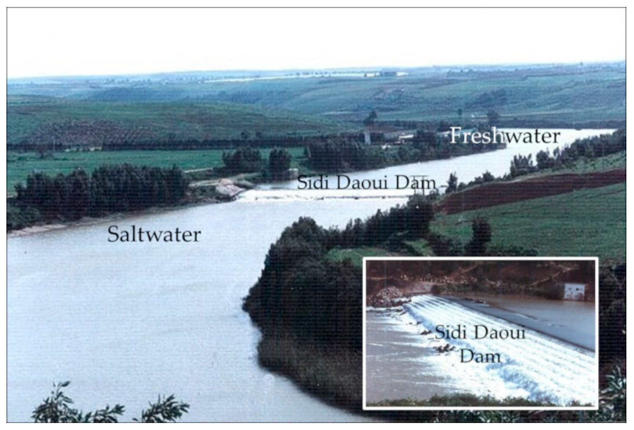
- Benzekri, M. La digue de Sidi Daoui. In Eau et Développement; Administration de l’Hydraulique: Rabat, Maroc, 1986; pp. 10–15. Available online: http://www.abhatoo.net.ma/content/download/33363/725781/version/1/file/LA+DIGUE+DE+SIDI+DAOUI.pdf (accessed on 30 May 2019).
- Snoussi, M. Nature, estimation et comparaison des flux de matière issus des bassins versants de l’Adour (France), du Sebou, de l’Oum Er-Rbia et du Souss (Maroc). Impact du climat sur les apports fluviatiles à l’océan. Ph.D. Thesis, Université Mohamed V, Rabat, Maroc, 1986. [Google Scholar]
- El Jakani, M. Estuaire de l’Oum Er-Rbia: évolution géomorphologique et impact des aménagements en amont, hydrodynamique, fonctionnement et organisation hydro-chimique et géochimie du phosphore. Ph.D. Thesis, Université Mohammed V, Rabat, Maroc, 2003. [Google Scholar]
- Green, M.O.; MacDonald, I.T. Processes driving estuary infilling by marine sands on an embayed coast. Mar. Geol. 2001, 178, 11–37. [Google Scholar] [CrossRef]
- Silvester, R. Growth of crenulate shaped bays to equilibrium. J. Waterw. Harb. Coast. Eng. Div. 1970, 96, 275–287. [Google Scholar]
- Halouani, N.; Sabatier, F.; Gueddari, M.; Fleury, J. 2007. Évolution du trait de côte de Tabarka-Bouterfess, nord-ouest de la Tunisie. Mediteranée 2007, 108, 131–137. [Google Scholar] [CrossRef]
- FitzGerald, D.M.; buynevich, I.; Hein, C. Morphodynamics and Facies Architecture of Tidal Inlets and Tidal Deltas. In Principales of Tidal Sedimentology; Davis, R., Jr., Dalrymple, R., Eds.; Springer: Dordrecht, The Netherlands, 2011; pp. 301–333. ISBN 978-94-007-0123-6. [Google Scholar]
- Beressolier, C.; Thomas, Y.F. Méthodes pour l’étude d’une plage: Le port Blanc, sédimentologie et géomorphologie. In Mémoires du laboratoire de géomorphologie de l’école pratique de hautes études; Laboratoire de géomorphologie EPHE: Dinard, France, 1983; Volume 39, p. 89. ISBN 2900111153. [Google Scholar]
- Nahon, A.; Freire, P.; Pires, A.R.; Dodet, G.; Bertin, X.; Freitas, M.; Fortunato, A.B.; Andrade, C. Morphodynamique d’une embouchure tidale artificielle éphémère: La lagune d’Albufeira, Portugal. In Proceedings of the Actes desXIIèmes Journées Nationales Génie Côtier–Génie Civil, Cherbourg, France, 12–14 January 2012; pp. 355–362. [Google Scholar] [CrossRef]
- Idrissi, H.; Tahiri, l.; Bernoussi, A.; Chafik, A.; Taleb, H. Evaluation de la salubrité du littoral méditerranéen et atlantique nord (Saidia–Safi) durant la période 1992–1994; Travaux et document; Institut Scientifique des Pêches Maritimes; Office National des Pêches: Rabat, Maroc, 1994; Volume 77, p. 90. [Google Scholar]
- Thomas, C.G.; Spearman, J.R.; Turnbull, M.J. Historical morphological change in the Mersey Estuary (Conference Paper). Cont. Shelf Res. 2002, 22, 1775–1794. [Google Scholar] [CrossRef]
- Dodet, G.; Bertin, X.; Bruneau, N.; Fortunato, A.B.; Nahon, A.; Taborda, R. Interactions vagues-courants dans une embouchure tidale dominée par la houle. In Proceedings of the Actes des XIIèmes Journées Nationales Génie Côtier–Génie Civil, Cherbourg, France, 12–14 January 2012; pp. 41–50. [Google Scholar] [CrossRef]
- Fortunato, A.B.; Nahon, A.; Dodet, G.; Pires, A.R.; Freitas, M.; Bruneau, N.; Azevedo, A.; Bertin, X.; Benevides, P.; Andrade, C.; et al. Morphological evolution of an ephemeral tidal inlet from opening to closure: The Albufeira inlet, Portugal. Cont. Shelf Res. 2014, 73, 49–63. [Google Scholar] [CrossRef]
- Académie Hassan II des Sciences et Techniques. Risques naturels: Séisme, ondes de tempête et phénomènes climatiques extremes; Actes de la session plénière solennelle: Rabat, Maroc, 2015; p. 332. ISBN 978 9954 9598 0 0. [Google Scholar]


| Period | Cumulative Capacity Managed (Mm3) | Rate Relative to Total Capacity (%) | Added Value in % of Capacity | Average Volume of Water Supply to the Estuary ± Standard Deviation (Mm3) |
|---|---|---|---|---|
| 1926–1953 | 30.2 | 0.6 | +0.6 | 251 ± 280 |
| 1954–1970 | 1511.2 | 28.5 | +27.9 | 298 ± 295 |
| 1979–2001 | 4548.7 | 85.8 | +57.3 | 33 ± 25 |
| 2002–2017 | 5301.7 | 100.0 | +14.2 | 24 ± 54 |
| Year | Image Source | Estuary Outlet Width (m) | Axis Direction of the Estuary Outlet | Surface Sedimentary Balance (m2) | Tendency |
|---|---|---|---|---|---|
| 1970 | ANCFCC | 125 | 5° NNE | Reference position | - |
| 1982 | ANCFCC | 82 | 5° NNE | +6644 | Clogging |
| 1988 | ANCFCC | 49 | 7° NNW | +153,108 | Clogging |
| 2004 | Google Earth 1 | 61 | 35° NNW | Reference position | - |
| 2009 | Google Earth 1 | 49 | 46° NNW | −189,383 | Unclogging |
| 2011 | Google Earth 1 | 127 | 32° NNW | −18,630 | Unclogging |
| 2012 | Google Earth 1 | 59 | 44° NNW | +68,763 | Clogging |
| 2014 | Google Earth 1 | 45 | 54° NNW | +28,383 | Clogging |
| 2016 | Google Earth 1 | 28 | 49° NNW | −26,390 | Unclogging |
| 2017 | Google Earth 1 | 96 | 30° NNW | −37,115 | Unclogging |
| Period | Surface balance in m2 | |
|---|---|---|
| El Haouzia Beach | L.A. El Bahria Beach | |
| 1970–1988 | +94,700 | −1373 |
| 2004–2009 | +10,149 | +19,824 |
| 2009–2011 | −73,462 | −175,148 |
| 2011–2012 | +59,819 | −13,820 |
| 2012–2014 | −3109 | −37,087 |
| 2014–2016 | −19,301 | −139,076 |
| 2016–2017 | −10,941 | +13,395 |
| Overall Balance | +57,855 | −333,285 |
© 2019 by the authors. Licensee MDPI, Basel, Switzerland. This article is an open access article distributed under the terms and conditions of the Creative Commons Attribution (CC BY) license (http://creativecommons.org/licenses/by/4.0/).
Share and Cite
El Jakani, M.; Ettazarini, S.; Rhinane, H.; Raji, M.; Radid, M.; Talbi, M. Impact of Anthropogenic Facilities on the Morphodynamic Evolution of an Estuarine System: The Case of Oum Er-Rbia Estuary (Azemmour, Morocco). J. Mar. Sci. Eng. 2019, 7, 248. https://doi.org/10.3390/jmse7080248
El Jakani M, Ettazarini S, Rhinane H, Raji M, Radid M, Talbi M. Impact of Anthropogenic Facilities on the Morphodynamic Evolution of an Estuarine System: The Case of Oum Er-Rbia Estuary (Azemmour, Morocco). Journal of Marine Science and Engineering. 2019; 7(8):248. https://doi.org/10.3390/jmse7080248
Chicago/Turabian StyleEl Jakani, Mustapha, Said Ettazarini, Hassan Rhinane, Mohammed Raji, Mohamed Radid, and Mohamed Talbi. 2019. "Impact of Anthropogenic Facilities on the Morphodynamic Evolution of an Estuarine System: The Case of Oum Er-Rbia Estuary (Azemmour, Morocco)" Journal of Marine Science and Engineering 7, no. 8: 248. https://doi.org/10.3390/jmse7080248