Gas Hydrate Estimate in an Area of Deformation and High Heat Flow at the Chile Triple Junction

 , , ,
, , ,  ,
,  ,
,
Abstract
:
1. Introduction
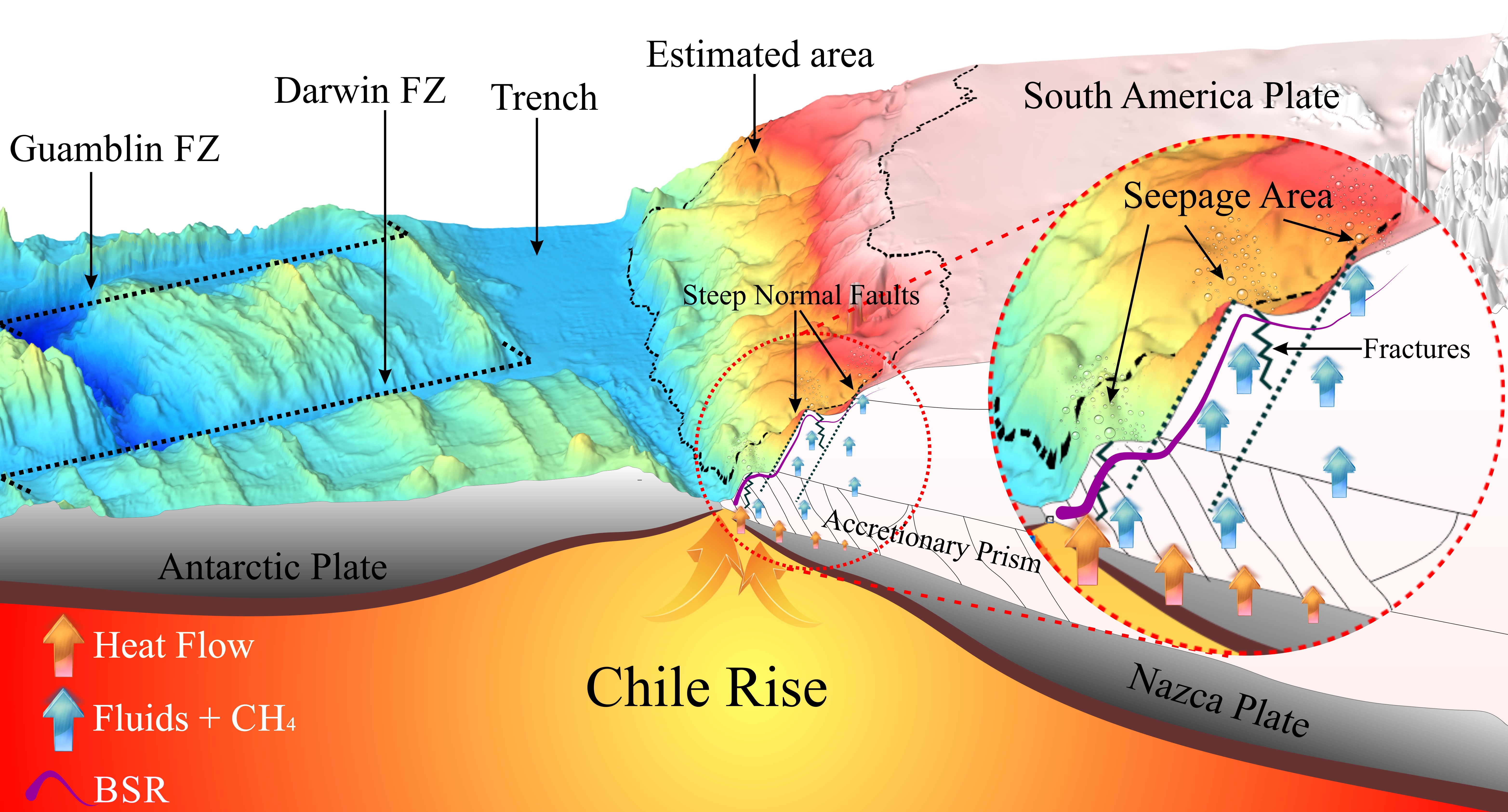
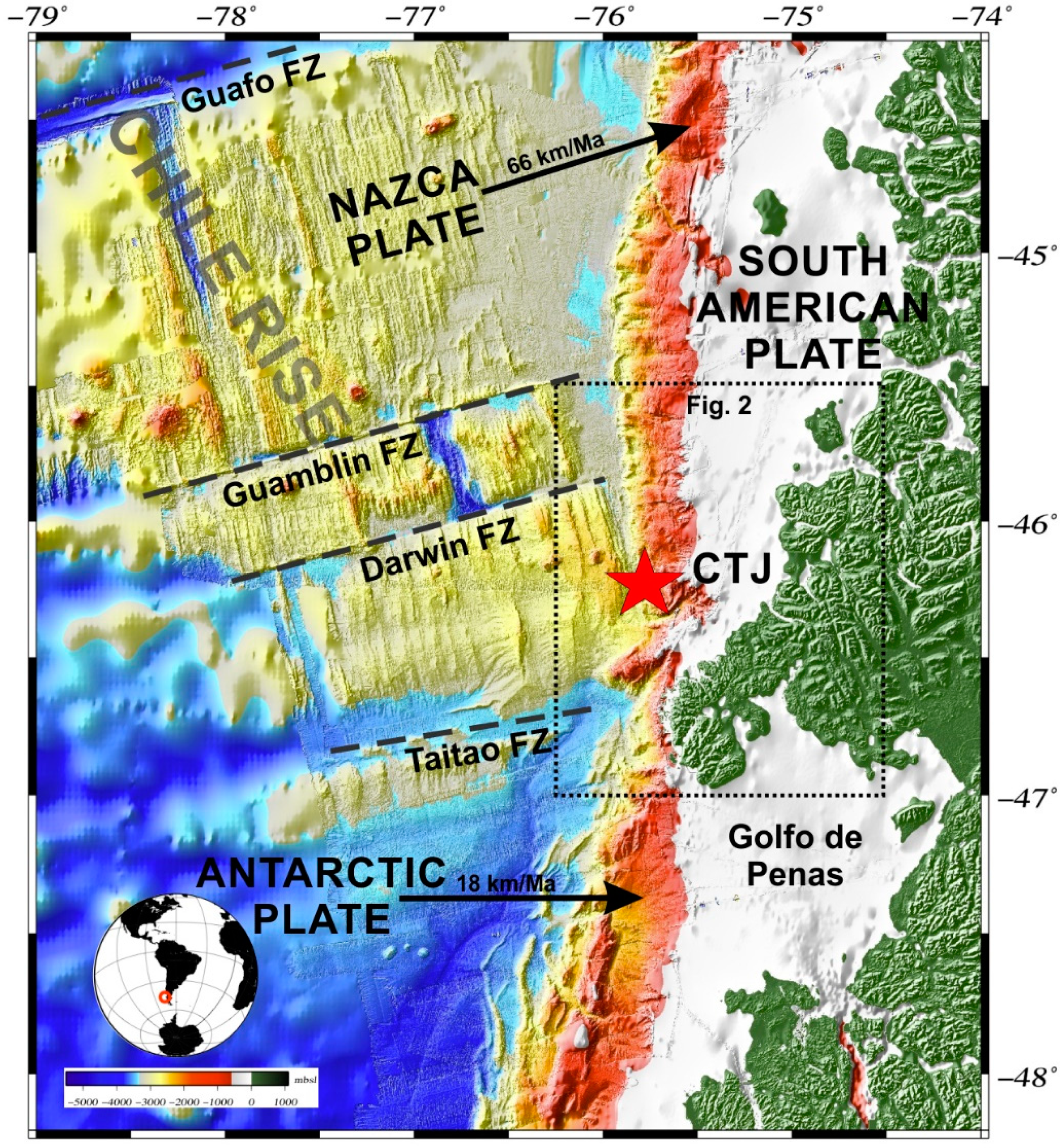
Geological Setting
2. Materials and Methods
2.1. Database
2.2. Methods
3. Results
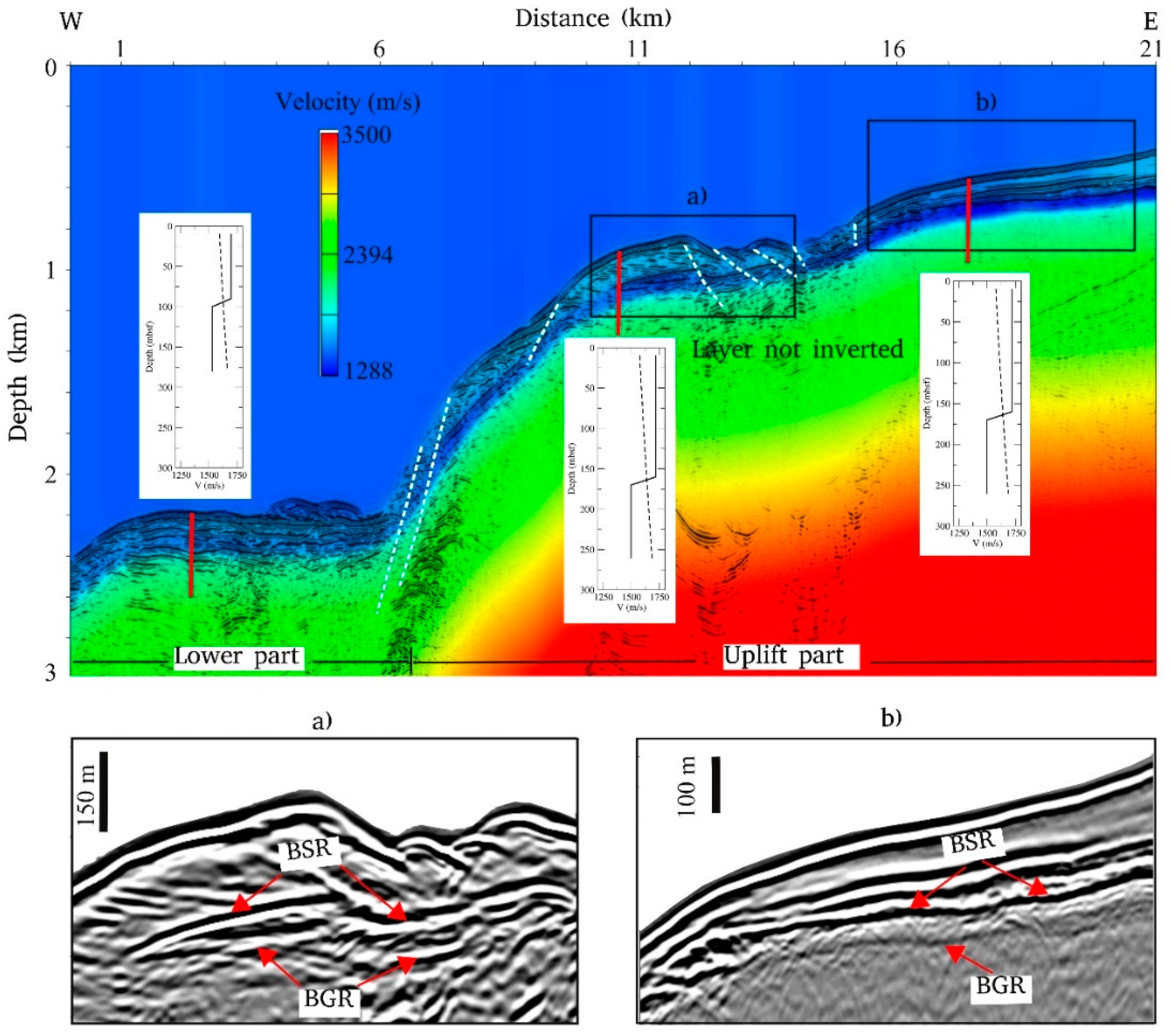
3.1. BSR Identification
3.2. Seismic Velocity Model
3.3. Gas-Phases Estimates
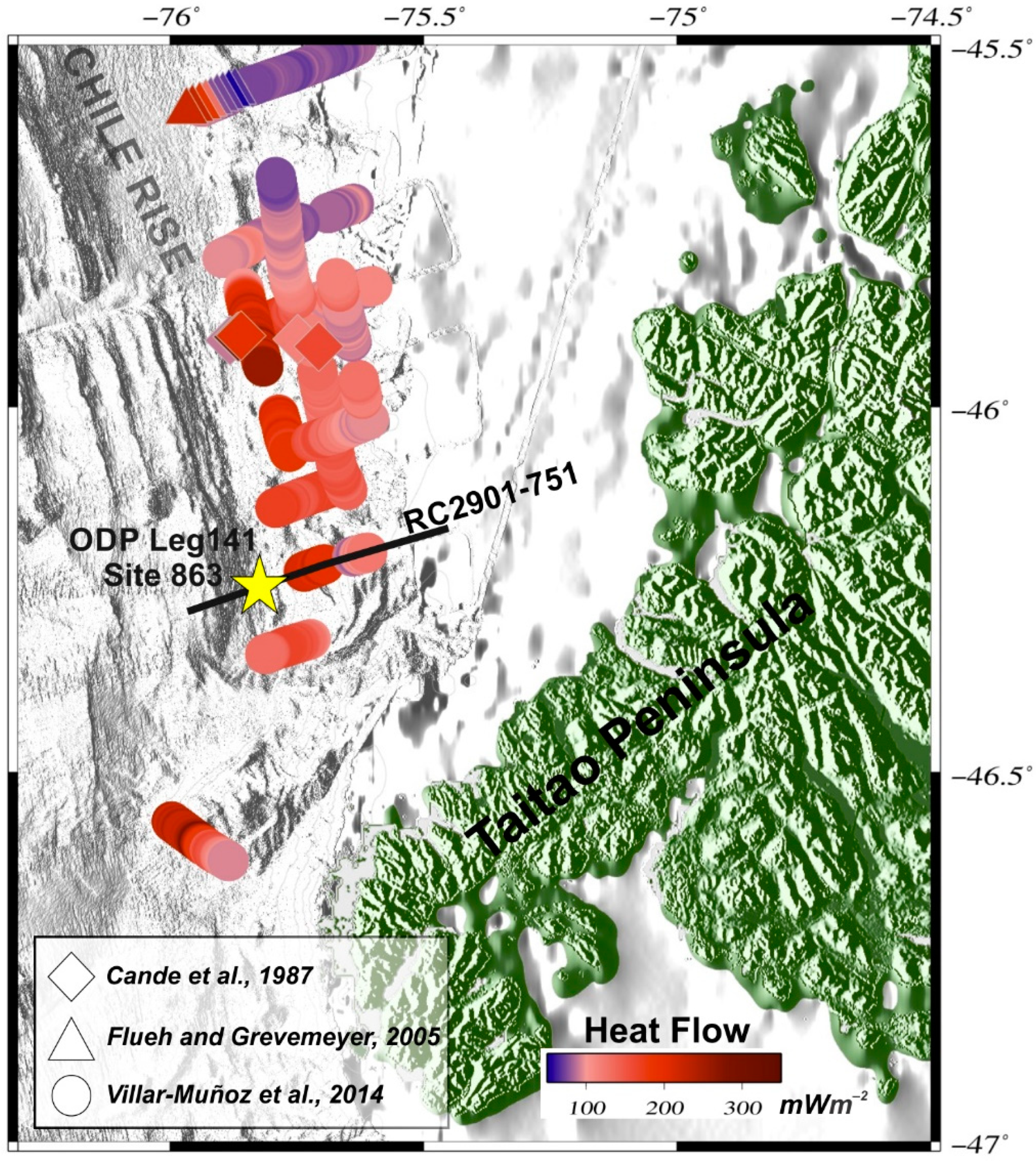
3.4. Geothermal Gradient
3.5. Gas Hydrate and Free Gas Volume at Standard Temperature and Pressure Conditions
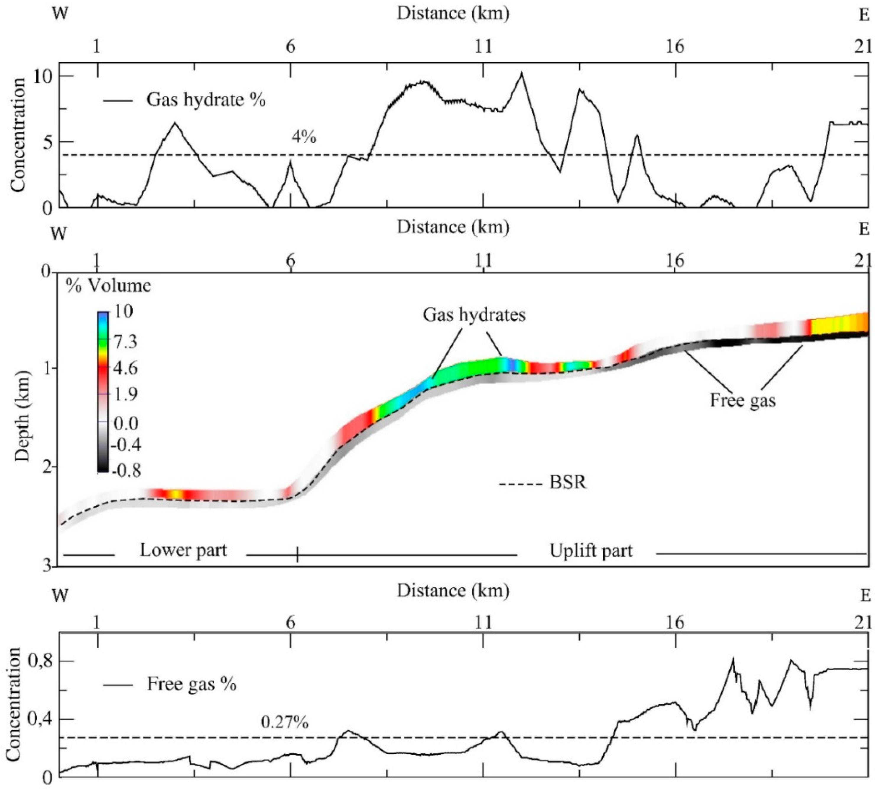
- For gas hydrate: 4% of the total volume (dashed line in the upper panel of Figure 4), 50% porosity, thickness of the gas hydrate layer equal to 108 m, and a total projected area of about 2300 km2. Considering these assumptions, the methane budget is 7.21 × 10¹¹ m3 at STP conditions;
- For free gas: 0.27% of the total volume (dashed line in the lower section of Figure 4), 50% porosity, thickness of the free gas layer equal to 85 m, and a total projected area of about 2,300 km2. Considering these assumptions, the methane budget from gas hydrates is 4.1 × 10¹⁰ m3 at STP conditions.
4. Discussion
5. Conclusions
- The values for gas hydrate concentration are lower than 10% of the total rock volume. The highest concentrations are calculated in shallower waters, where the geothermal gradient is low and deformation is less prevalent;
- The amount of hydrate and free gas estimated over the studied area were 7.21 × 10¹¹ m3 and 4.1 × 10¹⁰ m3, respectively;
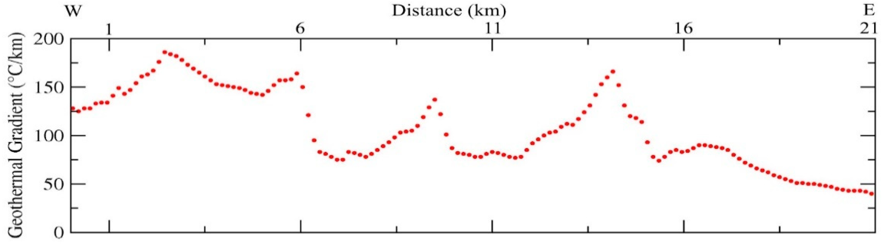
- An inverse correlation between gas-phase concentrations and geothermal gradient is recognized. Low gas hydrate and free gas concentrations coincide with high values of geothermal gradients over the studied area;
- An extremely high geothermal gradient close to the trench was calculated, reaching values up to 190 °C·km−1, caused by the subduction of the CR at the CTJ, altering the stable PT conditions for the gas hydrate, which promotes its dissociation and upward migration, and fluid escapes;
- High heat flow, tectonic faulting, and vigorous fluid advection may be important factors for hydrate and gas reservoir distribution offshore Taitao Peninsula;
- The CTJ is an important methane seepage area and should be the focus of novel geological, oceanographic, and ecological research.
Author Contributions
Funding
Acknowledgments
Conflicts of Interest
References
- Sloan, E.D. Fundamental principles and applications of natural gas hydrates. Nature 2003, 426, 353–363. [Google Scholar] [CrossRef] [PubMed]
- Sloan, E.D.; Koh, C. Clathrate Hydrates of Natural Gases, 3rd ed.; CRC Press: Boca Raton, FL, USA, 2007; 752p. [Google Scholar]
- Schmidt, M.; Hensen, C.; Morz, T.; Müller, C.; Grevemeyer, I.; Wallmann, K.; Mau, S.; Kaul, N. Methane hydrate accumulation in Mound 11 mud volcano, Costa Rica forearc. Mar. Geol. 2005, 216, 77–94. [Google Scholar] [CrossRef]
- Sloan, E.D. Clathrate Hydrates of Natural Gases, 2nd ed.; CRC Press: Boca Raton, FL, USA, 1998; 705p. [Google Scholar]
- Milkov, A.V. Global estimates of hydrate-bound gas in marine sediments: How much is really out there? Earth-Sci. Rev. 2004, 66, 183–197. [Google Scholar] [CrossRef]
- Crutchley, G.J.; Mountjoy, J.J.; Pecher, I.A.; Gorman, A.R.; Henrys, S.A. Submarine Slope Instabilities Coincident with Shallow Gas Hydrate Systems: Insights from New Zealand Examples. In Submarine Mass Movements and their Consequences; Advances in Natural and Technological Hazards Research; Lamarche, G., Mountjoy, J., Bull, S., Hubble, T., Krastel, S., Lane, E., Micallef, A., Moscardelli, L., Mueller, C., Pecher, I., Eds.; Springer: Cham, Switzerland, 2016; 41p. [Google Scholar]
- Hovland, M.; Orange, D.; Bjorkum, P.A.; Gudmestad, O.T. Gas hydrate and seeps-effects on slope stability: The “hydraulic model”. In Proceedings of the Eleventh International Offshore and Polar Engineering Conference, Stavanger, Norway, 17–22 June 2001; Volume 1, pp. 471–476. [Google Scholar]
- Kretschmer, K.; Biastoch, A.; Rüpke, L.; Burwicz, E. Modeling the fate of methane hydrates under global warming. Glob. Biogeochem. Cycles 2015, 29, 610–625. [Google Scholar] [CrossRef] [Green Version]
- Mountjoy, J.J.; Pecher, I.; Henrys, S.; Crutchley, G.; Barnes, P.M.; Plaza-Faverola, A. Shallow methane hydrate system controls ongoing, downslope sediment transport in a low-velocity active submarine landslide complex, Hikurangi Margin, New Zealand. Geochem. Geophys. Geosyst. 2014, 15, 4137–4156. [Google Scholar] [CrossRef] [Green Version]
- Ruppel, C.D.; Kessler, J.D. The interaction of climate change and methane hydrates. Rev. Geophys. 2017, 55, 126–168. [Google Scholar] [CrossRef] [Green Version]
- Bangs, N.L.; Sawyer, D.S.; Golovchenko, X. Free gas at the base of the gas hydrate zone in the vicinity of the Chile triple Junction. Geology 1993, 21, 905–908. [Google Scholar] [CrossRef]
- Hyndman, R.D.; Spence, G.D. A seismic study of methane hydrate marine bottom-simulating-reflectors. J. Geophys. Res. 1992, 97, 6683–6698. [Google Scholar] [CrossRef]
- Kvenvolden, K.A. Comparison of marine gas hydrates in sediments of an active and passive continental margin. Mar. Pet. Geol. 1985, 2, 65–70. [Google Scholar] [CrossRef]
- Vargas-Cordero, I.; Tinivella, U.; Accaino, F.; Loreto, M.F.; Fanucci, F.; Reichert, C. Analyses of bottom simulating reflections offshore Arauco and Coyhaique (Chile). Geo-Mar. Lett. 2010, 30, 271–281. [Google Scholar] [CrossRef]
- Brown, K.M.; Bangs, N.L.; Froelich, P.N.; Kvenvolden, K.A. The nature, distribution, and origin of gas hydrate in the Chile Triple Junction region. Earth Planet. Sci. Lett. 1996, 139, 471–483. [Google Scholar] [CrossRef]
- Grevemeyer, I.; Kaul, N.; Díaz-Naveas, J.L. Geothermal evidence for fluid flow through the gas hydrate stability field off Central Chile-transient flow related to large subduction zone earthquakes? Geophys. J. Int. 2006, 166, 461–468. [Google Scholar] [CrossRef] [Green Version]
- Loreto, M.F.; Tinivella, U.; Ranero, C. Evidence for fluid circulation, overpressure and tectonic style along the Southern Chilean margin. Tectonophysics 2007, 429, 183–200. [Google Scholar] [CrossRef]
- Polonia, A.; Brancolini, G.; Torelli, L.; Vera, E. Structural variability at the active continental margin off southernmost Chile. J. Geodyn. 1999, 27, 289–307. [Google Scholar] [CrossRef]
- Polonia, A.; Brancolini, G.; Torelli, L. The accretionary complex of southernmost Chile from the strait of Magellan to the Drake passage. Terra Antarct. 2001, 8, 87–98. [Google Scholar]
- Polonia, A.; Torelli, L. Antarctic/Scotia plate convergence off southernmost Chile. Geol. Acta 2007, 5, 295–306. [Google Scholar]
- Polonia, A.; Torelli, L.; Brancolini, G.; Loreto, M.F. Tectonic accretion versus erosion along the southern Chile trench: Oblique subduction and margin segmentation. Tectonics 2007, 26, TC3005. [Google Scholar] [CrossRef]
- Vargas-Cordero, I.; Tinivella, U.; Accaino, F.; Loreto, M.F.; Fanucci, F. Thermal state and concentration of gas hydrate and free gas of Coyhaique, Chilean Margin (44° 30′ S). Mar. Pet. Geol. 2010, 27, 1148–1156. [Google Scholar] [CrossRef]
- Vargas-Cordero, I.; Tinivella, U.; Accaino, F.; Fanucci, F.; Loreto, M.F.; Lascano, M.E.; Reichert, C. Basal and Frontal Accretion Processes versus BSR Characteristics along the Chilean Margin. J. Geol. Res. 2011, 2011, 1–10. [Google Scholar] [CrossRef] [Green Version]
- Vargas-Cordero, I.; Tinivella, U.; Villar-Muñoz, L.; Giustiniani, M. Gas hydrate and free gas estimation from seismic analysis offshore Chiloé island (Chile). Andean Geol. 2016, 43, 263–274. [Google Scholar] [CrossRef]
- Vargas-Cordero, I.; Tinivella, U.; Villar-Muñoz, L. Gas Hydrate and Free Gas Concentrations in Two Sites inside the Chilean Margin (Itata and Valdivia Offshores). Energies 2017, 10, 2154. [Google Scholar] [CrossRef]
- Villar-Muñoz, L.; Behrmann, J.H.; Diaz-Naveas, J.; Klaeschen, D.; Karstens, J. Heat flow in the southern Chile forearc controlled by large-scale tectonic processes. Geo-Mar. Lett. 2014, 34, 185–198. [Google Scholar] [CrossRef]
- Villar-Muñoz, L.; Bento, J.P.; Klaeschen, D.; Tinivella, U.; Vargas-Cordero, I.; Behrmann, J.H. A first estimation of gas hydrates offshore Patagonia (Chile). Mar. Pet. Geol. 2018, 96, 232–239. [Google Scholar] [CrossRef]
- Coffin, R.; Pohlman, J.; Gardner, J.; Downer, R.; Wood, W.; Hamdan, L.; Walker, S.; Plummerg, R.; Gettrus, J.; Diaz, J. Methane hydrate exploration on the mid Chilean coast: A geochemical and geophysical survey. J. Pet. Sci. Eng. 2007, 56, 32–41. [Google Scholar] [CrossRef]
- Geersen, J.; Scholz, F.; Linke, P.; Schmidt, M.; Lange, D.; Behrmann, J.H.; Volker, D.; Hensen, C. Fault zone controlled seafloor methane seepage in the rupture area of the 2010 Maule earthquake, Central Chile. Geochem. Geophys. Geosyst. 2016, 17, 4802–4813. [Google Scholar] [CrossRef] [Green Version]
- Jessen, G.L.; Pantoja, S.; Gutierrez, M.A.; Quinones, R.A.; Gonzalez, R.R.; Sellanes, J.; Kellermann, M.Y.; Hinrichs, K.U. Methane in shallow cold seeps at Mocha Island off central Chile. Cont. Shelf Res. 2011, 31, 574–581. [Google Scholar] [CrossRef]
- Sellanes, J.; Quiroga, E.; Gallardo, V. First direct evidence of methane seepage and associated chemosynthetic communities in the bathyal zone off Chile. J. Mar. Biol. Assoc. UK 2004, 84, 1065–1066. [Google Scholar] [CrossRef]
- Sellanes, J.; Krylova, E. A new species of Calyptogena (Bivalvia, Vesicomyidae) from a recently discovered methane seepage area off Concepción Bay, Chile (36S). J. Mar. Biol. Assoc. UK 2005, 85, 969–976. [Google Scholar] [CrossRef]
- Sellanes, J.; Quiroga, E.; Neira, C. Megafaunal community structure and trophic relationships of the recently discovered Concepción Methane Seep Area (Chile, 36S). ICES J. Mar. Sci. 2008, 65, 1102–1111. [Google Scholar] [CrossRef]
- Scholz, F.; Hensen, C.; Schmidt, M.; Geersen, J. Submarine weathering of silicate minerals and the extent of pore water freshening at active continental margins. Geochim. Cosmochim. Acta 2013, 100, 200–216. [Google Scholar] [CrossRef]
- German, C.R.; Shank, T.M.; Lilley, M.D.; Lupton, J.E.; Blackman, D.K.; Brown, K.M.; Baumberger, T.; FrühGreen, G.; Greene, R.; Saito, M.A.; et al. Hydrothermal Exploration at the Chile Triple Junction—ABE’s Last Adventure. In AGU Fall Meeting Abstracts; American Geophysical Union: Washington, DC, USA, 2010. [Google Scholar]
- Oliver, P.G.; Sellanes, J. New species of Thyasiridae from a methane seepage area off Concepción, Chile. Zootaxa 2005, 1092, 1–20. [Google Scholar] [CrossRef]
- Völker, D.; Geersen, J.; Contreras-Reyes, E.; Sellanes, J.; Pantoja, S.; Rabbel, W.; Thorwart, M.; Reichert, C.; Block, M.; Weinrebe, W.R. Morphology and geology of the continental shelf and upper slope of southern Central Chile (33S–43S). Int. J. Earth Sci. (Geol. Rundsch.) 2014, 103, 1765. [Google Scholar] [CrossRef]
- Olu, K.; Duperret, A.; Sibuet, M.; Foucher, J.P.; Fiala-Medioni, A. Structure and distribution of cold seep communities along the Peruvian active margin: Relationship to geological and fluid patterns. Mar. Ecol. Prog. Ser. 1996, 132, 109–125. [Google Scholar] [CrossRef]
- Behrmann, J.H.; Lewis, S.D.; Cande, S.C. Tectonics and geology of spreading ridge subduction at the Chile Triple Junction: A synthesis of results from Leg 141 of the Ocean Drilling Program. Geol. Rundsch. 1994, 83, 832–852. [Google Scholar] [CrossRef]
- Hillman, J.I.T.; Klaucke, I.; Bialas, J.; Feldman, H.; Drexler, T.; Awwiller, D.; Atgin, O.; Çifçi, G. Gas migration pathways and slope failures in the Danube Fan, Black Sea. Mar. Pet. Geol. 2018, 92, 1069–1084. [Google Scholar] [CrossRef]
- Hovland, M.; Svensen, H.; Forsberg, C.F.; Johansen, H.; Fichler, C.; Fosså, J.H.; Jonsson, R.; Rueslåtten, H. Complex pockmarks with carbonate-ridges off mid-Norway: Products of sediment degassing. Mar. Geol. 2005, 218, 191–206. [Google Scholar] [CrossRef]
- Römer, M.; Sahling, H.; Pape, T.; Bohrmann, G.; Spieß, V. Quantification of gas bubble emissions from submarine hydrocarbon seeps at the Makran continental margin (offshore Pakistan). J. Geophys. Res. 2012, 117, C10015. [Google Scholar] [CrossRef]
- Vargas-Cordero, I.; Tinivella, U.; Villar-Muñoz, L.; Bento, J.P. High Gas Hydrate and Free Gas Concentrations: An Explanation for Seeps Offshore South Mocha Island. Energies 2018, 11, 3062. [Google Scholar] [CrossRef]
- Tinivella, U.; Carcione, J.M. Estimation of gas-hydrate concentration and free-gas saturation from log and seismic data. Lead Edge 2001, 20, 200–203. [Google Scholar] [CrossRef]
- Cisternas, M.; Atwater, B.F.; Torrejón, F.; Sawai, Y.; Machuca, G.; Lagos, M.; Eipert, A.; Youlton, C.; Salgado, I.; Kamataki, T.; et al. Predecessors of the giant 1960 Chile earthquake. Nature 2005, 437, 404–407. [Google Scholar] [CrossRef]
- Agurto-Detzel, H.; Rietbrock, A.; Bataille, K.; Miller, M.; Iwamori, H.; Priestley, K. Seismicity distribution in the vicinity of the Chile Triple Junction, Aysén Region, southern Chile. J. S. Am. Earth Sci. 2014, 51, 1–11. [Google Scholar] [CrossRef] [Green Version]
- Murdie, R.E.; Prior, D.J.; Styles, P.; Flint, S.S.; Pearce, R.G.; Agar, S.M. Seismic responses to ridge-transform subduction: Chile triple junction. Geology 1993, 21, 1095–1098. [Google Scholar] [CrossRef]
- Fischer, D.; Mogollón, J.M.; Strasser, M.; Pape, T.; Bohrmann, G.; Fekete, N.; Spiess, V.; Kasten, S. Subduction zone earthquake as potential trigger of submarine hydrocarbon seepage. Nat. Geosci. 2013, 6, 647–651. [Google Scholar] [CrossRef]
- Sibson, R.H. Interactions between temperature and pore fluid pressure during earthquake faulting—A mechanism for partial or total stress relief. Nat. Phys. Sci. 1973, 243, 66–68. [Google Scholar] [CrossRef]
- Boobalan, A.J.; Ramanujam, N. Triggering mechanism of gas hydrate dissociation and subsequent submarine landslide and ocean wide Tsunami after Great Sumatra-Andaman 2004 earthquake. Arch. Appl. Sci. Res. 2013, 5, 105–110. [Google Scholar]
- Elger, J.; Berndt, C.; Rüpke, L.H.; Krastel, S.; Gross, F.; Geissler, W.H. Submarine slope failures due to pipe structure formation. Nat. Commun. 2018, 9, 715. [Google Scholar] [CrossRef] [PubMed]
- Kvenvolden, K.A. Gas hydrates-geological perspective and global change. Rev. Geophys. 1993, 31, 173–187. [Google Scholar] [CrossRef]
- Waite, W.F.; Santamarina, J.C.; Cortes, D.D.; Dugan, B.; Espinoza, D.N.; Germaine, J.; Jang, J.; Jung, J.W.; Kneafsey, T.J.; Shin, H.; et al. Physical properties of hydrate-bearing sediments. Rev. Geophys. 2009, 47, RG4003. [Google Scholar] [CrossRef]
- Xu, W.; Germanovich, L.N. Excess pore pressure resulting from methane hydrate dissociation in marine sediments: A theoretical approach. J. Geophys. Res. 2006, 111. [Google Scholar] [CrossRef]
- Behrmann, J.H.; Lewis, S.D.; Musgrave, R.; Bangs, N.; Bodén, P.; Brown, K.; Collombat, H.; Didenko, A.N.; Didyk, B.M.; Froelich, P.N.; et al. Chile Triple Junction. In Proc. ODP. Init. Repts. (Pt. A) 1992, 141, 1–708. [Google Scholar]
- Cande, S.C.; Leslie, R.B. Late Cenozoic tectonics of the southern Chile trench. J. Geophys. Res. 1986, 91, 471–496. [Google Scholar] [CrossRef]
- Cande, S.C.; Leslie, R.B.; Parra, J.C.; Hodbart, M. Interaction between the Chile ridge and Chile trench: Geophysical and geothermal evidences. J. Geophys. Res. 1987, 92, 495–520. [Google Scholar] [CrossRef]
- Herron, E.M.; Cande, S.C.; Hall, B.R. An active spreading center collides with a subduction zone: A geophysical survey of the Chile margin triple Junction. Mem. Geol. Soc. Am. 1981, 154, 683–701. [Google Scholar]
- Brown, K.M.; Bangs, N.L.; Marsaglia, K.; Froleich, P.N.; Zheng, Y.; Didyk, B.M.; Prior, D.; Richford, E.L.; Torres, M.; Kumsov, V.B.; et al. A summary of ODP 141 hydrogeologic, geochemical, and thermal results. Proc. ODP Sci. Results 1995, 141, 363–373. [Google Scholar]
- Flueh, E.; Grevemeyer, I. FS SONNE Cruise Report SO 181 TIPTEQ-from the Incoming Plate to Megathrust Earthquakes. Rep. 06.12.2004–26.02.2005; Leibniz-Institut für Meereswissenschaften an der University Kiel: Kiel, Germany, 2005; 533p. [Google Scholar]
- Völker, D.; Grevemeyer, I.; Stipp, M.; Wang, K.; He, J. Thermal control of the seismogenic zone of southern central Chile. J. Geophys. Res. 2011, 116, B10305. [Google Scholar] [CrossRef]
- Lagabrielle, Y.; Guivel, C.; Maury, R.; Bourgois, J.; Fourcade, S.; Martin, H. Magmatic-tectonic effects of high thermal regime at the site of active ridge subduction: The Chile Triple Junction model. Tectonophysics 2000, 326, 255–268. [Google Scholar] [CrossRef]
- German, C.R.; Ramirez-Llodra, E.; Baker, M.C.; Tyler, P.A. ChEss Scientific Steering Committee. Deep-Water Chemosynthetic Ecosystem Research during the Census of Marine Life Decade and Beyond: A Proposed Deep-Ocean Road Map. PLoS ONE 2011, 6, e23259. [Google Scholar] [CrossRef]
- Bangs, N.L.; Brown, K.M. Regional heat flow in the vicinity of the Chile Triple Junction constrained by the depth of the bottom simulating reflection. Proc. ODP Sci. Results 1995, 141, 253–259. [Google Scholar]
- Behrmann, J.H.; Kopf, A. Balance of tectonically accreted and subducted sediment at the Chile Triple Junction. Int. J. Earth Sci. (Geol. Rundsch.) 2001, 90, 753–768. [Google Scholar] [CrossRef]
- Bourgois, J.; Martin, H.; Lagabrielle, Y.; Le Moigne, J.; Frutos Jara, J. (Chile margin triple junction area) Subduction erosion related to spreading-ridge subduction: Taitao peninsula. Geology 1996, 24, 723–726. [Google Scholar] [CrossRef]
- Bangs, N.L.; Cande, S.C. Episodic development of a convergent margin inferred from structures and processes along the southern Chile margin. Tectonics 1997, 16, 489–503. [Google Scholar] [CrossRef] [Green Version]
- Cohen, J.K.; Stockwell, J.W. CWP/SU: Seismic Unix Release 4.0: A Free Package for Seismic Research and Processing; Center for Wave Phenomena, Colorado School of Mines: Golden, CO, USA, 2008; pp. 1–153. [Google Scholar]
- Loreto, M.F.; Tinivella, U.; Accaino, F.; Giustiniani, M. Offshore Antarctic Peninsula gas hydrate reservoir characterization by geophysical data analysis. Energies 2011, 4, 39–56. [Google Scholar] [CrossRef]
- Yilmaz, O. Seismic Data Analysis: Processing, Inversion and Interpretation of Seismic Data, 2nd ed.; Society of Exploration Geophysicists: Oklahoma, OK, USA, 2001; 2027p. [Google Scholar]
- Liu, Z.; Bleistein, N. Migration velocity analysis: Theory and an iterative algorithm. Geophysics 1995, 60, 142–153. [Google Scholar] [CrossRef]
- Hamilton, E.L. Sound velocity gradients in marine sediments. J. Acoust. Soc. Am. 1979, 65, 909–922. [Google Scholar] [CrossRef]
- Tinivella, U. A method for estimating gas hydrate and free gas concentrations in marine sediments. Bollettino di Geofisica Teorica ed Applicata 1999, 40, 19–30. [Google Scholar]
- Tinivella, U. The seismic response to overpressure versus gas 638 hydrate and free gas concentration. J. Seism. Explor. 2002, 11, 283–305. [Google Scholar]
- Grevemeyer, I.; Villinger, H. Gas hydrate stability and the assessment of heat flow through continental margins. Geophys. J. Int. 2001, 145, 647–660. [Google Scholar] [CrossRef] [Green Version]
- Ryan, W.B.F.; Carbotte, S.M.; Coplan, J.O.; O’Hara, S.; Melkonian, A.; Arko, R.; Weissel, R.A.; Ferrini, V.; Goodwillie, A.; Nitsche, F.; et al. Global Multi-Resolution Topography synthesis. Geochem. Geophys. Geosyst. 2009, 10, Q03014. [Google Scholar] [CrossRef]
- Peng, D.; Robinson, D.B. A new two-constant equation of state. Ind. Eng. Chem. Fundam. 1976, 15, 59–64. [Google Scholar] [CrossRef]
- Barth, G. Methane Gas Volume Expansion Ratios and Ideal Gas Deviation Factors for the Deep Water Bering Sea Basins; USGS Open-File Report; USGS: Reston, VA, USA, 2005; 1451p.
- Reeburgh, W.S. Oceanic Methane Biogeochemistry. Chem. Rev. 2007, 107, 486–513. [Google Scholar] [CrossRef] [Green Version]
- Cynar, F.J.; Yayanos, A.A. Biogeochemistry of Global Change: Radiatively Active Trace Gases; Oremland, R.S., Ed.; Chapman-Hall: Atlanta, GA, USA, 1993; pp. 551–573. [Google Scholar]
- McCollom, T.M. Abiotic methane formation during experimental serpentinization of olivine. PNAS 2016, 113, 13965–13970. [Google Scholar] [CrossRef] [PubMed] [Green Version]
- Johnson, J.E.; Mienert, J.; Plaza-Faverola, A.; Vadakkepuliyambatta, S.; Knies, J.; Bünz, S.; Andreassen, K.; Ferré, B. Abiotic methane from ultraslow-spreading ridges can charge Arctic gas hydrates. Geology 2015, 43, 371–374. [Google Scholar] [CrossRef]
- Bach, W.; Paulick, H.; Garrido, C.J.; Ildefonse, B.; Meurer, W.P.; Humphris, S.E. Unraveling the sequence of serpentinization reactions: Petrography, mineral chemistry, and petrophysics of serpentinites from MAR 15°N (ODP Leg 209, Site 1274). Geophys. Res. Lett. 2006, 33, 4–7. [Google Scholar] [CrossRef]
- Kelley, D.S.; Karson, J.A.; Früh-Green, G.L.; Dana, R.; Yoerger, D.R.; Shank, T.M.; Butterfield, D.A.; Hayes, J.M.; Schrenk, M.O.; Olson, E.J.; et al. A serpentinite-hosted ecosystem: The Lost City hydrothermal vent field. Science 2005, 307, 1428–1434. [Google Scholar] [CrossRef] [PubMed]
- Suess, E.; Torres, M.; Bohrmann, G.; Collier, R.W.; Greinert, J.; Linke, P.; Rehder, G.; Tréhu, A.; Wallmann, K.; Winckler, G.; et al. Gas hydrate destabilization: Enhanced dewatering, benthic material turnover and large methane plumes at the Cascadia convergent margin. Earth Planet. Sci. Lett. 1999, 170, 1–15. [Google Scholar] [CrossRef]


| Interval (mbsl) | Area (m2) | Temperature (K) | Pressure (MPa) | Volume in-situ (m3) | Volume STP (m3) | Volume Expansion Ratio |
|---|---|---|---|---|---|---|
| 500–1000 | 4.19 × 10⁸ | 285.8 | 7.6 | 4.25 × 10⁷ | 3.69 × 10⁹ | 86.8 |
| 1000–1500 | 4.37 × 10⁸ | 289.7 | 12.7 | 4.44 × 10⁷ | 6.71 × 10⁹ | 151.2 |
| 1500–2000 | 5.59 × 10⁸ | 291.0 | 17.7 | 5.68 × 10⁷ | 1.20 × 10¹⁰ | 212.2 |
| 2000–2500 | 3.69 × 10⁸ | 291.5 | 22.8 | 3.75 × 10⁷ | 9.90 × 10⁹ | 263.9 |
| 2500–3000 | 2.79 × 10⁸ | 292.1 | 27.9 | 2.84 × 10⁷ | 8.67 × 10⁹ | 305.5 |
| Total | 2.06 × 10⁹ | 2.10 × 10⁸ | 4.10 × 10¹⁰ |
© 2019 by the authors. Licensee MDPI, Basel, Switzerland. This article is an open access article distributed under the terms and conditions of the Creative Commons Attribution (CC BY) license (http://creativecommons.org/licenses/by/4.0/).
Share and Cite
Villar-Muñoz, L.; Vargas-Cordero, I.; Bento, J.P.; Tinivella, U.; Fernandoy, F.; Giustiniani, M.; Behrmann, J.H.; Calderón-Díaz, S. Gas Hydrate Estimate in an Area of Deformation and High Heat Flow at the Chile Triple Junction. Geosciences 2019, 9, 28. https://doi.org/10.3390/geosciences9010028
Villar-Muñoz L, Vargas-Cordero I, Bento JP, Tinivella U, Fernandoy F, Giustiniani M, Behrmann JH, Calderón-Díaz S. Gas Hydrate Estimate in an Area of Deformation and High Heat Flow at the Chile Triple Junction. Geosciences. 2019; 9(1):28. https://doi.org/10.3390/geosciences9010028
Chicago/Turabian StyleVillar-Muñoz, Lucía, Iván Vargas-Cordero, Joaquim P. Bento, Umberta Tinivella, Francisco Fernandoy, Michela Giustiniani, Jan H. Behrmann, and Sergio Calderón-Díaz. 2019. "Gas Hydrate Estimate in an Area of Deformation and High Heat Flow at the Chile Triple Junction" Geosciences 9, no. 1: 28. https://doi.org/10.3390/geosciences9010028