Introduction
As a participant in a Geological Survey of Canada field party, the author spent 2 months in 1967 in south-western Ellesmere Island (Fig. 1), During this period a study of glacial erosion and deposition was carried out with special reference to the ice-cored moraines.
These ice-cored moraines are similar in position to those described from the vicinity of Thule. Greenland. Despite the expression “Thule-Baffin moraine" proposed by Reference WeetermanWeertman 1961), the descriptive term ice-cored moraine which was coined by Reference stremØstretn (1965) will be used here.
No nunataks are present in the area investigated, so all of the debris comprising the moraines must have come from beneath the glacier. Since bedrock contacts can be projected under the glacier, the sources of debris in different parts of the moraines can be determined.
Description Of The Area
The main ice cap in south-western Ellesmere Island is located north of South Gape (Fig. 2). Measuring approximately 60 km in an east-west direction and 50 km north-south, this ice cap reaches an altitude of t 600 m north-west of South Cape Fiord. As noted by McLaren (in Reference FortierFortier and others. 1963, p. 310-14;, there is a striking contrast between the northern part of this ice cap with its gentle topography and the more dissected southern part where outlet glaciers flow down steep valleys into fiords.
The north-west margin of the ice cap consists of several lobes fringed by ice-cored moraines. These lobes cover different types of rocks, a situation particularly favorable for studying the source of material in the moraines.
The bedrock in the study area consists of Devonian sedimentary rocks of the Sverdrup Basin. They dip gently to the north-north-west, along part of the southern limb of a broad syncline, the Schei Syncline. Of particular interest in this study (Fig. 3) are two members of the Okse Bay FormationFootnote * (Reference FortierFortier and others, 1963):
2. Lower sandstone and shale member; red-brown and grey-green shales and sandstones (Dob2).Footnote *
1. Lower sandstone member; yellow-brownish and grey sandstones (Dob1)Footnote *.

Fig. 1. Map showing the location of lite area investigated in south-western Ellesmere Island.
The contact between the two members is very striking in the field due to the color differences and to the relatively lower resistance to erosion of the red shales and sandstones. This contact is of particular importance to the present subject because it can be projected beneath the ice with confidence and thus it can be used in studying the sources of debris in ice-cored moraines. A fault (fin Figure 3) is presentFootnote * just north of the ice lobe studied at the contact between Dob1 and Dob2. However, due to slight vertical and horizontal displacement, it is of no importance to this study.
Description Of Moraines
The ice-cap margin in the study area generally consists of an ice ramp, the slope of which varies from 20° to 35°. The lower parts of these ramps are masked by snow accumulation due to the prevailing winds which have an easterly to south-easterly component. However. ice cliffs are locally present, for example, at localities A, B, E, N and P (Fig. 3). Except at locality E, the ice cliffs are approximately 10 m high and are composed of pure blue-white glacier ice. There is usually a snow-scree slope masking the lower part of the cliff. When this snow is absent or when the upper glacier ice overhangs the lower beds, a situation occurring at locality B, foliation bands including some debris are visible in the lower part. Dry calving is typical under these conditions. The ramps lead up to ice-cored morainic ridges. These moraines fringe the ice-cap margin and may rise more than 10 m above the ice surface. The ridges are composed of fragments of local rocks which have come from within 3 km of the present ice-cap margin.

Fig. 2. The main ice cap in South-western Ellesmere Island and the study area.
At localities D and H in Figure 3. two or more ridges exist instead of one. A more precise description is necessary for these areas because they play a key role in the subsequent discussion.
Locality D
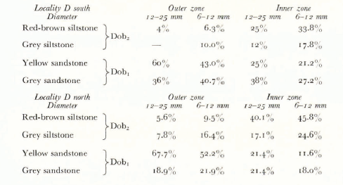
At locality D, outer and inner zones can be distinguished in the morainic deposits. Lithologically, these zones are quite different and have been distinguished by stone counts. Two size ranges have been selected for the counts: 6-12 mm and 12-25 mm (equivalent diameter). In order to obtain a representative sample, in each case at least 200 pebbles were counted.
The pebbles from the outer zone of the moraine are largely yellow and grey sandstones. whereas those from the inner zone have a much greater proportion of red-brown sillstone fragments (Table I). The difference in red-brown siltstone content is particularly striking. This lithological difference is also clearly marked in the size fractions > 25 mm and 6 mm. Yellow sandstone boulders are particularly abundant in the outer zone, in contrast to siltstone and grey sandstone boulders in the inner one. The fines consist of yellow-brownish sand in the outer zone and red-brown mud in the inner one.

Fig. 3. The marginal zone of the ice lobe investigated (from air photograph Ellesmere 16756/50; Air Photo Division. Deportment of Energy, Mines and Resources, Canada).
Another feature of the moraines at locality D is the occurrence in the inner zone of an unusually large boulder lifted up from the base of the ice cap; it is 15 m long, 5.5 m wide and 7 m high. The bedding in this block dips steeply down-glacier and the block itself consists of, in a downward sequence, 2.55 m of red-brown interbedded siltstone and sandstone, 0.20 m of green siltstone and 2.75 m of yellow-grey sandstone. The contact between the two lower members of the Okse Bay Formation is preserved in this blockFootnote * which has been lifted as a whole despite the great differences in lithology. The same contact also occurs close to the glacier margin in the vicinity of the moraine. The trend of the moraine, like the ice lobe, is oblique to the lithological contact (Fig. 3). Because there are no nunataks up-glacier from the moraine, it appears that this block was plucked from the base of the glacier and subsequently raised to the surface. The bedding in the block dips at 72° to the north-west and the bedrock in this area dips at 10° to the north-north-west. Cross-bedding in the block and the observed sequence of strata indicate that the block is right side up. Thus this piece of bedrock has been lifted and the dip has been increased from about 10^ to about 72”. From an estimate
Table I. Lithological Composition Of Moraines At Locality d

of the travel distance and the ablation rate, a calculation of the strain-rate is possible. However, this has not been done because it is not certain that the block has not slumped or has not rotated through an additional 360°.
Between the ice-cap margin and the moraines at locality D, foliation bands including some debris could be seen dipping up-glacier towards the end of the ablation season as indicated in Figure 3. Only in this area was this upwarping of foliation bands clearly visible in the field; elsewhere the snow cover was too extensive and persistent.
The lithological compositions of pebbles in these bands are similar to those of the pebbles in the outer zone of the morainic deposit and to those of the pebbles in the ice below the ice cliff north of locality B (Table II). There are some small differences, but the striking feature is the low content of red-brown siltstone (Dob2) fragments in each case, especially in comparison with the inner zone (Table I).
The general conclusion to be drawn from the stone counts is that the inner ice-cored moraine zone at locality D appears to derive its debris from a point nearer to the ice-cap margin than does the outer zone or the ice between the outer zone and the margin.
Table II. Lithological composition of moraines in and on the ice
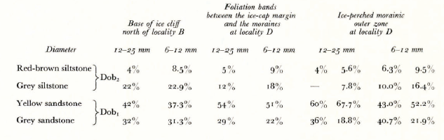

Fig. 4. Structural relationships at localities D and H (western part).
The debris within the ice lying beneath the outer ice-cored moraine zone and the englacial debris lying between this moraine and the ice-cap margin occurs in bands parallel to the ice foliation. The inner morainic zone, with its distinctive lithology, is slightly oblique (10°) to the general trend of the outer zone and disappears north of locality D (Fig. 4). Its trend suggests that it cuts across the outer zone before its disappearance.
Locality H
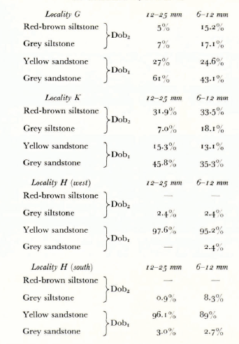
Distinct morainic ridges can be distinguished near locality H. They also differ from each other lithologically (Table III) but the pattern is not the same as that at locality D.
Table III. Lithological composition of moraines at localities G, H and K

The outer morainic zone (localities G and K) has a mixed composition with a relatively large amount of red-brown siltstone and grey sandstone but the inner zone (locality H) is characterized by a much greater proportion of yellow sandstone and the absence of red-brown siltstone.
Some ridges are oblique to the ice-cap margin and cross the foliation bands. A careful examination of the western part of moraine H (Fig. 3) shows that localized zones cross each other independently of the trend of the main ridge (Fig. 4). A similar situation has been observed in Antarctica (Reference SouciiezSouchez, 1967).
Other localities
In the vicinity of the melt stream north of locality C and south of locality E, the inner part of the moraine has in some places mounds of angular grey sandstone blocks resulting probably from in situ frost-shattering of pieces of bedrock lifted up from the base of the ice cap. However, it has not been possible to determine whether they are the result of the same mechanism as the inner zone at locality D.
At localities G and I, large numbers of well-rounded cobbles are present in the moraine at the ice surface. They are mixed with angular pebbles and fines in till pillars on the moraine just south of locality G where the moraine disappears and they are concentrated just east of locality I (Fig. 3). They are interpreted as outwash deposits formed during general déglaciation and subsequently incorporated into the moraine. The presence of this material indicates that a re-advance of the ice margin has occurred since the outwash deposits formed.
Formation Of Ice-Cored Moraines
The formation of Arctic ice-cored moraines has been studied in the Thule area, Greenland (Reference BishopBishop, 1957;Reference SwinzowSwinzow, 1962;Reference HookeHooke, 1968), and in Baffin Island (Reference GoldthwaitGoldthwait, 1951). Reference WeetermanWeertman (1961) used in his paper, which criticized the shear hypothesis and gave an alternative explanation, the expression “Thule-Baffin moraines”.
At locality D the foliation bands are upwarped at the glacier margin. From the top to the base of the ice ramp, when the latter is not masked by snow (sometimes mud in summer), the foliation bands with included debris dip up-glacier at approximately 26 28°. Blocks of bedrock are visible within the ice; the largest one found was 28 cm long. Ko wedge of clean ice exists. Because of melt-water gullies, foliation and debris bands can be traced; thus sedimentation on an old ice toe with subsequent re-incorporation into the glacier can be ruled out. As noted in Table II, debris in these bands is lithologically similar to that in the outer zone of the moraine and to that in the foliation bands at the base of the ice cliff north of locality B. Thus it appears that the outer zone of the moraine at locality D is the result of upwarping of foliation bands at the ice-cap margin, of subsequent concentration of debris by ablation, and of insulation of the ice against melting and sublimation, giving rise to the present perched position of the ridge.The only mechanism which seems to be able to satisfactorily account for debris parallel to the foliation is that of basal freezing (Reference WeetermanWeertman, 1961). However, the stone counts for the inner zone at locality D are not consistent with this mechanism. Here, the large proportion of red-brown siltstone fragments suggests that this debris has come from a source closer to the ice-cap margin. The lithology of the slab of bedrock 15 m long which had been brought to the surface in this inner zone also suggests the same fact. However, another possibility must be considered: the occurrence of an outlier of Dob2 within the Dob, zone under the ice cap which could be the source for the debris in the inner morainic zone (for example, a result of faulting or an anticlinal axis which reverses the dip). Although it cannot be proved that it does not exist, it seems improbable in view of the structural characteristics near the ice lobe and because of the trend and narrow width of this zone. Localized fault zones in the glacier ice seem to be a possible explanation for the trend of the moraine at both localities D and H and for the anomalous stone counts for the inner moraine at locality D.
At locality H, the general pattern of the moraines (Fig. 3) strongly suggests bedrock obstruction to ice flow. The outer moraine has a mixed composition with large amounts of grey sandstone and red-brown siltstone, but the inner ridge is almost entirely composed of yellow sandstone both in its western and southern parts. An inward displacement of the active zone of erosion is thus required, though the angle between the flow direction of the ice lobe and the bedrock-outcrop pattern is low in this locality.
A rough estimate of the time needed to accumulate the quantity of debris comprising the moraine at the ice surface has been made during this study. This has been done, after estimation of the ablation rate, from moraine-thickness measurements and determination of debris concentration in the ice.
Moraine-thickness measurements at localities C, D and O give values between 0.01 and 1.1 m. The central parts of different ridges are often between 0.7 and 1.1. m so that a representative value is 0.9 m.
Determination of debris concentration in the ice has been carried out in foliation bands at localities B. D and O along the lower parts of ice cliffs or ramps. The sites chosen were characterized by the presence of most of the debris layers; thus the values obtained must be considered, from this point of view, as maximum ones. There are large errors in this method, because of the method of determining the sub-surface concentration of debris caused by melting of ice and, because it is assumed that this concentration does not change along the foliation, which is certainly incorrect. Furthermore, some of the debris is carried away by melt water. A concentration of 6% by volume is considered as a representative mean value for the selected sites with abundant debris.
Ablation rates, which have not yet been measured on this ice cap, are estimated from a comparison with nearby regions ( Reference Baird, Ward and OrvigBaird and others, 1952-53; Reference MüllerMüller, 1962) to be between 0.3 and t m/year for a clean ice surface.Reference stremØstrem (1965) carried out experiments to investigate the ablation rate under a thin layer of till. The relation that he obtained between ablation and thickness of till cover indicates, for example, that the rate of ablation under a 10 cm thick till is reduced to 40% of the value for uncovered glacier ice; under a 30 cm thick till it is reduced to 20%. The curve given by Reference stremØstrem (1965, fig. 15) has been taken into account in the present calculation. It is thus assumed that the same figure is valid for Ellesmere Island as for Scandinavia.
In accordance with the ablation rate chosen, the results give 65 to 200 years for the quantity of debris forming the moraine to appear at the ice surface.
Acknowledgements
The author wishes to express his gratitude 10 Dr J. Fyles and Dr W. Blake. Jr. of the Geological Survey of Canada, for the opportunity of going to Arctic Canada and for the kindness shown towards him.
Thanks are due also to Dr R. L. Hooke, Department of Geology, University of Minnesota, Minneapolis, to Drs R. A. Achard, B. C. McDonald and W. Blake. Jr, of the Geological Survey of Canada, Ottawa, who kindly reviewed the manuscript. The author is also indebted to Dr J. W. Kerr, of the Institute of Sedimentary and Petroleum Geology, Calgary, Alberta, for providing base-camp facilities, helicopter support and advice concerning the structure and stratigraphy of south-western Ellesmere Island and for giving valuable comments.