


Abstract
A global transformation in semi-arid cropping systems is occurring as dryland (non-irrigated) farmers in semi-arid regions shift from crop rotations reliant on year-long bare fallows, called summer fallow, to more intensively cropped systems. Understanding the rate of cropping system intensification at the landscape scale is critical to estimating the economic and environmental implications of this movement. Here, we use high-resolution satellite data to quantify dryland cropping patterns from 2008 to 2016 in the US High Plains. We use these estimates to scale up our previous field-level research in this region on soil carbon, herbicide use, yields, and profitability. Over the nine year study period, the High Plains witnessed a profound shift in cropping systems, as the historically dominant wheat-fallow system was replaced by more intensified rotations as the dominant systems by land area. Out of the 4 million hectares of non-irrigated cropland in the study area, this shift coincided with a 0.5 million-hectare decline in summer fallow and a concurrent increase in alternative (non-wheat) crops. We estimate that, from 2008 to 2016, these patterns resulted in a 0.53 Tg (9%) increase in annual grain production, 80 million USD (10%) increase in annual net farm operating income, substantial reductions in herbicide use, and an increase in C sequestration that corresponds to greenhouse gas reductions of 0.32 million metric tons of CO2 equivalents per year (MMTCO2e yr−1). We project each of these implications to a scenario of potential maximum 100% intensification and estimate that, relative to 2016 levels, herbicide use would be reduced by more than half, grain production would increase by 25%, net operating income would increase by 223 million USD (26%), and greenhouse gases would be reduced by an additional 0.8 MMTCO2e yr−1. The scale of cropping intensification in the High Plains and its environmental and economic impacts has important implications for other regions undergoing similar transformations, and for policy that can either support or hinder these shifts toward more sustainable cropping systems.
Export citation and abstract BibTeX RIS

Original content from this work may be used under the terms of the Creative Commons Attribution 3.0 licence. Any further distribution of this work must maintain attribution to the author(s) and the title of the work, journal citation and DOI.
Introduction
A global transition in semi-arid cropping systems is underway, with implications for the environment and economies of semi-arid regions [1, 2]. Semi-arid regions constitute 20% of Earth's land surface and are home to nearly 1 billion people [3, 4]. These large and growing populations have placed pressure on dryland (non-irrigated) farms in semi-arid regions and the natural resources on which they depend. As much as 40% of agricultural land globally suffers from severe soil degradation [4], and dryland soils are especially vulnerable due to water limitations that constrain crop productivity and exacerbate soil erosion [5]. Crop production and soil health are further constrained in semi-arid dryland cropping systems by a common practice of a year-long fallow period called summer fallow, where no crops are grown and weeds are controlled. While summer fallow reduces risk of crop failure by accumulating precipitation in the soil, decades of crop rotations with frequent summer fallow have led to degraded soils and management systems dependent on large and increasing amounts of chemical inputs [6, 7]. However, over the last several decades, technological advancements such as no-till have enabled farmers to intensify cropping systems by replacing summer fallow with a crop, which has the potential to reverse or slow these detrimental economic and environmental trends.
Typically, agricultural intensification is supported by a greater use of chemical inputs. For example, the observed doubling in global agricultural production from the 1960s to the 1990s coincided with almost a seven fold increase in nitrogen (N) inputs and a three fold increase in pesticide use, with cascading effects for the environment and human health [8–11]. In contrast, data from on-farm and research station studies have shown that semi-arid cropping intensification can increase crop production and residues returned to the soil while reducing chemical inputs [12, 13]. As a result, reducing summer fallow frequency can simultaneously contribute to desirable environmental and economic outcomes. However, the extent of recent intensification patterns, and the potential impacts of broader adoption, have not been characterized at regional and broader landscape scales.
The transformation in semi-arid cropping systems has been documented in several regions around the world, including Australia, Canada, and the Northern Great Plains [1, 2, 14], but the extent of these trends has not been quantified in the High Plains of the US—an important grain growing region in the Western Great Plains including the states of Colorado, Kansas, and Nebraska. Since the Dust Bowl in the 1930s, most dryland farmers in the High Plains have grown a rotation of winter wheat and summer fallow to mitigate the risk of farming in a highly variable and dry climate. However, many no-till farmers are transitioning from wheat-fallow to a mid-intensity rotation (e.g. wheat-corn-fallow), and some have even eliminated summer fallow completely through diverse crop rotations, a practice called continuous cropping. Continuous cropping likely provides a greater environmental and economic benefit relative to mid-intensity and wheat-fallow [12, 15], but previous estimates of intensification have only been derived from changes in individual crop or fallow acreages, and thus we lack an estimate of cropping systems-level changes. For example, Hansen et al [14] report a reduction in summer fallow acres by 70% in the US Northern Great Plains since 1990, and Maaz et al [2] report similar reductions in several Canadian provinces, suggesting that millions of hectares are being intensified. Better understanding the extent and degree of cropping system intensification could provide policymakers with information about the economic and environmental implications of these transformations, and place these shifts into the broader context of global cropping system intensification.
Agricultural communities across the United States, including those in the High Plains, are facing significant economic pressures. Over half of US farm households lose money on their farm operations each year, and most farmers today cannot survive without off-farm income and government subsidies [16, 17]. Over the past several decades, farmers have increasingly paid more for inputs like equipment and chemicals, while commodity prices have remained stagnant or declined, a phenomenon called the 'double squeeze' [18]. Given the pressure on profits, summer fallow creates an economic burden due to the high cost of herbicides required to maintain weeds in no-till systems, and gross incomes that are constrained by an entire year without crop production. However, by increasing precipitation use efficiency, total grain production can be enhanced by 60%–75% in intensified systems relative to wheat-fallow [13], and substantial herbicide reductions can be achieved through increased plant competition with weeds and the ability to rotate different herbicides in intensified systems [7, 19]. Additionally, Rosenzweig et al [12] found that, despite achieving greater crop production, continuous farmers in the High Plains apply similar amounts of nitrogen fertilizer as traditional wheat-fallow farmers while cutting herbicide use in half, leading to 80% greater net operating income (i.e. gross profit minus operating expenses, not including fixed costs). Intensification, and especially continuous cropping, can enable greater crop production without increases in fertilizer because the added plant diversity and carbon inputs enhance soil fertility and beneficial soil microbial populations [12]. Thus, the intensification of cropping systems may provide an opportunity to act on both sides of the double squeeze—to reduce inputs while enhancing crop production.
Due to the large amounts of land dedicated to dryland crop production, even proportionately small shifts in cropping patterns can translate to significant environmental impacts [20]. Scaling field-level estimates of C sequestration to the landscape level can inform US and international climate policy aimed at increasing terrestrial C offsets [21]. Parton et al [22] estimated that the Great Plains region (which encompasses the High Plains) only accounts for 5% of US agricultural greenhouse gas emissions, but also found that this region has the potential to become a net C sink through the adoption of sustainable agricultural technologies, particularly through reduced tillage. Intensified cropping systems increase soil organic carbon (SOC) beyond the effects of reducing tillage through greater crop-derived C input to soil [23]. The analysis by Parton et al, however, did not include the C sequestration benefits of cropping system intensification, and thus may have underestimated the region's potential to mitigate climate change.
We conducted a spatial analysis of cropping patterns in the High Plains from 2008 to 2016 to answer three questions: (1) To what extent is cropping system intensity increasing in the High Plains? (2) Which crops are replacing summer fallow and where? (3) What are the implications of observed intensification in the High Plains for C sequestration, grain yield, herbicide use, and net farm incomes? Assessing cropping system intensification patterns and potential implications in the High Plains will generate insights that will help us understand the broader semi-arid cropping transition occurring around the world.
Methods
Study area
The study area consists of the main semi-arid dryland cropping counties in the High Plains states of Colorado, Kansas, and Nebraska. Counties were selected if a majority of the area receives less than 500 mm average annual precipitation, estimated using rasterized data from PRISM [24]. Additionally, all selected counties had at least 2000 acres in dryland wheat production as of 2016. The study period (2008–2016) contained both wet and dry years relative to the 30 year average for the region (table 1).
Table 1. Average annual precipitation over the study region by year.
| Year | 30 year average | 2008 | 2009 | 2010 | 2011 | 2012 | 2013 | 2014 | 2015 | 2016 |
|---|---|---|---|---|---|---|---|---|---|---|
| Precipitation (mm) | 432 | 442 | 569 | 462 | 479 | 266 | 421 | 498 | 605 | 471 |
Data
All crop acreage and crop rotation analysis was performed using the Croplands Data Layer (CDL) accessed through CropScape provided by the National Agricultural Statistics Service (NASS). The CDL is a geo-referenced raster data layer using a combination of satellite imagery and extensive agricultural ground truthing [25]. The CDL contains agricultural land cover data for the contiguous United States, and has been used to estimate crop acreage, crop rotations, and rotational diversity over time [26–29]. CDL maps for Colorado, Kansas, and Nebraska for the years 2008 to 2016 were analyzed using ArcGIS. CDLs from 2008 and 2009 were generated at 56 m resolution, and were reprocessed to a 30 m resolution to match the resolution of the other years.
The CDL has low accuracy in classifying non-agricultural land-uses according to CDL metadata, and thus the 2011 National Land Cover Database (NLCD) was used to mask-out non-agricultural classes and grasslands, as others have done to isolate croplands specifically (e.g. Plourde et al [29]). Spatial irrigation data was used to mask-out irrigated acreage in Colorado using data from 2010 (and 2015 and 2016 only for the Republican River Basin) available from Colorado Decision Support Systems through the Colorado Department of Natural Resources [30]. Nebraska drylands were isolated by masking irrigated lands using data from 2005 available from the Nebraska Department of Natural Resources [31], and similarly for Kansas using data centered around 2007 provided by the Kansas Applied Remote Sensing Program [32].
Crop acreage
Crop pixel counts were converted to acres then hectares. We compared CDL estimates of crop acreage to Farm Service Agency (FSA) data from 2011 to 2016 [33]. Our estimates of crop acreage were always below those reported by FSA, but accuracy varied by crop. Accuracies in this study were high for major crops like corn (97%), winter wheat (92%), and sorghum (84%). Accuracies were lower for minor crops like millet (71%) and peas (42%), suggesting that there is much more land in production for these crops than estimated here [33].
While we removed much of the grasslands from the dataset using the NLCD, we found that many fallow acres were incorrectly classified as grasslands or open space in 2008, but classification improved gradually through subsequent years. Others have encountered similar confusions between grasslands and croplands [34], necessitating a means of correctly identifying these classes. We obtained more accurate assessments of fallow land (92% accuracy compared to FSA data) by classifying any fallow, grassland, or open space classes as fallow only if they were rotated with other crop classes.
Crop rotations
Cropping system intensities were assessed in three year sequences, and new rasters were generated denoting the three year cropping system intensity for each pixel. Crops were divided into three classes: winter wheat, fallow (including grassland and open space classes rotated with crops as previously discussed), and other crops. Crop-fallow was designated as all sequences with two occurrences of fallow or a wheat-fallow-wheat sequence, mid-intensity was designated as all sequences with one occurrence of fallow, and continuous was designated as all sequences with 0 occurrences of fallow. Sequences with three occurrences of fallow were classified as grassland or open space, and removed from subsequent analysis. The rasters of cropping system intensity were compared for each three year rotation window to produce maps of changes in cropping system intensity through time. Crop footprint maps were developed for each three year rotation window by including pixels if they grew a particular crop at any point in the three year period.
Soil carbon sequestration, herbicide use, grain production, and net income analyses
Recent studies measured the differences in SOC, annualized grain yield, and input use between the different cropping system intensities in the High Plains across 96 farm fields representing the geographic extent of the study area examined here [12, 15]. Data used for the spatial and regional analysis in this study include least-squared means and standard errors generated by statistical models of cropping system intensity and significant soil, management, and climate covariates (table 2). Sampling procedures for each metric are described in Rosenzweig et al [12, 15]. We obtained regional assessments of C sequestration, herbicide use, annualized nitrogen fertilizer use, grain production, and net operating income by multiplying the least-squared means and standard errors for each cropping system by the number of hectares in each cropping system for each year. We predicted theoretical maximum grain production, net operating income, C sequestration, and theoretical minimum herbicide usage based on a scenario of 100% adoption of continuous cropping practices by multiplying the mean value for continuous cropping systems (table 2) by the total number of dryland acres in the study region in 2016. While our maximum values assume that the systems are managed without tillage, our estimates predict only the potential benefits due to cropping intensification and do not account for any additional potential benefits due to shifting from till to no-till management.
Table 2. Summary values used to scale up implications of cropping system intensity to the landscape level based on soil sampling and management records from 96 no-till farm fields across the study region. Data are model-generated least-squared means ± SE. Letters represent significant differences between cropping system intensities (α = 0.1). PET = Potential evapotranspiration. Adapted from Rosenzweig et al [12, 15].
| Wheat-fallow | Mid-intensity | Continuous | |
|---|---|---|---|
| Glyphosate herbicide (kg AE ha−1 yr−1) | 1.79 ± 0.28a | 1.42 ± 0.15ab | 0.93 ± 0.25b |
| 2,4-D herbicide (kg AE ha−1 yr−1) | 0.82 ± 0.10a | 0.47 ± 0.05b | 0.15 ± 0.08c |
| Dicamba herbicide (kg AE ha−1 yr−1) | 0.17 ± 0.03a | 0.14 ± 0.02b | 0.05 ± 0.03c |
| Annualized nitrogen fertilizer | 30 ± 5b | 48 + 3a | 30 ± 4b |
| (kg N ha−1 yr−1) | |||
| Annualized grain yield (Mg ha−1 yr−1) | 1.27 ± 0.11b | 1.85 ± 0.11a | 2.03 ± 0.20a |
| Annualized net income ($ ha−1 yr−1) | 147 ± 36b | 250 ± 24a | 264 ± 39a |
| SOC stock (Mg ha−1) | 10.65 ± 0.41b | 11.10 ± 0.38ab | 12.30 ± 0.42a |
Results
Overall, we found substantial levels of cropping system intensification from 2008 to 2016, as alternative (non-wheat) crops replaced summer fallow. This regional transformation in cropping systems is likely associated with increases in soil C sequestration and crop production, and decreases in herbicide use, contributing to higher net farm operating incomes.
Changes in cropland
Non-irrigated cropland in the study area increased from 3.9 to 4.0 million hectares from 2008 to 2016. Crop-fallow was the dominant dryland cropping system in 2008, consisting of 2.1 million hectares, or 53% of dry cropland (figure 1). By 2016, however, crop-fallow only represented 42% of dry cropland, with mid-intensity and continuous rotations constituting 43% and 15% of dry cropland, respectively. Over the nine year period, land in mid-intensity rotations increased by 0.3 million hectares, and land in continuous rotations increased by 0.2 million hectares, while land in crop-fallow decreased by 0.4 million hectares (figures 1, 2). Transitions to continuous rotations were most pronounced in northeastern Colorado and southwestern Nebraska, whereas transitions to mid-intensity rotations were most pronounced in western Kansas (figure 2).
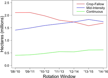
Figure 1. Land area in dryland cropping system rotations of crop-fallow (predominately wheat-fallow), mid-intensity (fallow one out of three years), and continuous rotations without fallow in three year rotation windows from 2008 to 2016 in the High Plains region of Colorado, Kansas, and Nebraska. Data derived from the NASS Croplands Data Layer.
Download figure:
Standard image High-resolution image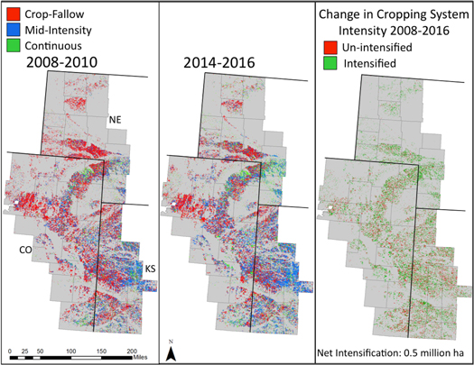
Figure 2. Maps of dryland cropping system intensity derived from three year rotation windows starting in 2008 (left panel) and 2014 (middle panel), and the change in cropping system intensity between the two rotation windows (right panel) in the High Plains region of Colorado, Kansas, and Nebraska. Data derived from the NASS Croplands Data Layer.
Download figure:
Standard image High-resolution imageReductions in summer fallow from 1.8 to 1.3 million hectares (48% to 33% of dry cropland) from 2008 to 2016 were largely matched by increases in alternative (non-wheat) crops (figure 3). Four crops (corn, sorghum, millet, and field peas) increased by nearly 0.4 million hectares, from 17% of dry cropland in 2008 to 26% by 2016 (figure 3), while increases in winter wheat remained proportional to overall increases in dry cropland. Corn and sorghum made up the vast majority of alternative crop acreage, although pea and millet acreage also increased substantially over the nine year period (figure 3). Surprisingly, sunflower acreage decreased by about a third. There was large inter-annual variability in crop acreage. Crop prices were unrelated to annual trends in crop acreage (data not shown). We suspect that large drops in acreage, as observed in corn and sorghum in 2014, are mostly related to abnormally wet conditions that prevented planting.
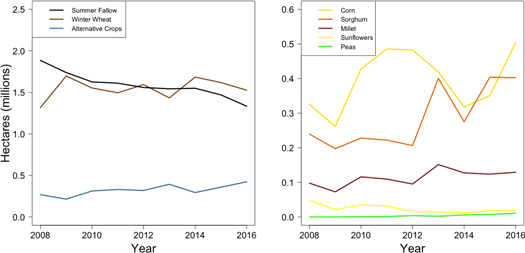
Figure 3. Dryland area growing various crops or under summer fallow management from 2008 to 2016 in the High Plains region of Colorado, Kansas, and Nebraska. Data derived from the NASS Croplands Data Layer.
Download figure:
Standard image High-resolution imageAlternative crops were adopted in distinct sub-regions within the High Plains (figure 4). Growth in sorghum production largely occurred in western Kansas and southeastern Colorado, and replaced much of the corn production in these regions. Corn was largely adopted further north (figure 4). Millet adoption mostly occurred in mid and northeastern Colorado and the southern Nebraska panhandle, and peas were adopted almost exclusively in northeastern Colorado and Nebraska (figure 4).
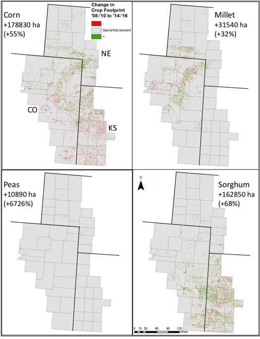
Figure 4. Change in production area of alternative dryland crops from 2008–2010 to 2014–2016 in the High Plains region of Colorado, Kansas, and Nebraska. Data represent net changes in cropland followed by the % change in parentheses.
Download figure:
Standard image High-resolution imageImplications of cropping system intensification
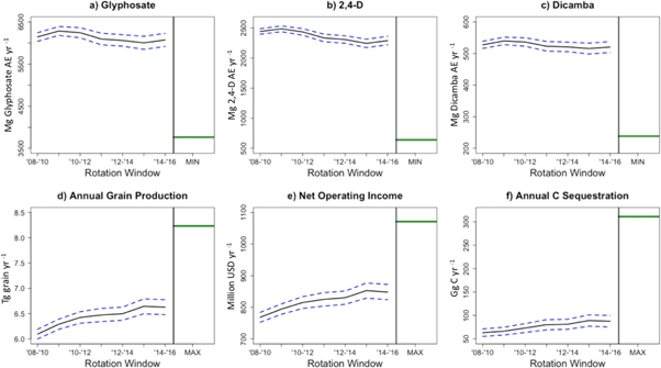
Cropping intensity also corresponds to decreases in herbicide use. Rosenzweig et al [12] found that continuously cropped farmers applied roughly 50%, 80%, and 60% less glyphosate, 2,4-D, and dicamba than wheat-fallow farmers, respectively, across this region. Scaling up these estimates to the landscape level suggests modest reductions in the use of three common herbicides (glyphosate, 2,4-D, and dicamba) were achieved from 2008 to 2016, despite increases in overall cropland. We estimate that annual glyphosate use decreased by 70 Mg acid equivalent (AE), or 1% (figure 5(a)), 2,4-D use decreased by 150 Mg AE (6%) (figure 5(b)), and dicamba use fell 7 Mg AE (1%) from 2008 to 2016 (figure 5(c)). We estimate that annual N fertilizer use increased by 6100 metric tons (3%) from 2008 to 2016 (data not shown).
Figure 5. Landscape-scale estimates of (a) Glyphosate use, (b) 2,4-D use, (c) Dicamba use, (d) Annual Grain Production, (e) Annual Net Income, and (f) C sequestration in the High Plains region of Colorado, Kansas, and Nebraska from for each three year rotation window from 2008 to 2016. Data denote means (solid lines) ± standard error (dashed lines), and green solid lines represent the theoretical maximum or minimum level for each metric based on 100% continuous crop adoption. Intensification effect estimates derived from Rosenzweig et al [12, 15] based on soil sampling and management records from 96 no-till farm fields across the study region.
Download figure:
Standard image High-resolution image
Using yield histories from 2010 to 2015, Rosenzweig et al [12] found that mid-intensity and continuous rotations had 46% and 60% greater annualized grain production relative to wheat-fallow, respectively, after accounting for the effects of fertilizer use and climate. These annualized production increases are despite 29% lower wheat yields in rotations without summer fallow before wheat. Expanding these estimates to the landscape scale suggests larger gains in crop production were realized than can be accounted for by increases in dry cropped acres alone (figure 5(d)). Production increases associated with land conversion to cropland were 0.17 Tg grain (3%) from 2008 to 2016. Including the annualized yield differences between cropping system intensities suggests an increase in grain production of 0.53 Tg (9%) from 2008 to 2016 (figure 5(d)).
Comparisons of partial enterprise budgets from 2010 to 2014 demonstrate the potential implications of cropping system intensification for regional economies. Rosenzweig et al [12] found that annualized net incomes were 70% and 80% higher in mid-intensity and continuous rotations compared to wheat-fallow, respectively. Scaling these results to the landscape level, we estimate that annual net operating incomes in dryland agriculture increased by 80 million USD (10%) from 2008 to 2016 due to intensification (figure 5(e)).
We recently assessed soil organic carbon (SOC) stocks to 10 cm on 96 dryland no-till fields across the full extent of the study area [15]. After accounting for potential evapotranspiration (PET) and soil clay content as covariates, we found that no-till mid-intensity rotations stored on average 0.02 Mg C ha−1 yr−1 and no-till continuous rotations stored 0.08 Mg C ha−1 yr−1 relative to no-till wheat-fallow. Scaling these results to the landscape-level trends in cropping system intensity suggests that soil C sequestration increased 38% from 2008 to 2016, with levels of annual C sequestration from dryland agriculture reaching 88 Gg C yr−1, or 0.32 MMTCO2e, by 2016 (figure 5(f)).
We predicted theoretical maximum grain production (figure 5(d)), net operating income (figure 5(e)), C sequestration (figure 5(f)), and theoretical minimum herbicide usage (figures 5(a)–(c)) by calculating these metrics based on a scenario of 100% adoption of no-till, continuous cropping practices. Theoretical minimum glyphosate usage (at 100% continuous cropping adoption) is 3760 Mg AE yr−1, or about 60% of the 2016 level (figure 5(a)). Minimum 2,4-D usage is 640 AE yr−1, or 28% of 2016 levels (figure 5(b)). Minimum dicamba usage is 240 Mg AE yr−1, less than half of 2016 levels (figure 5(c)).
Theoretical maximum grain production is 8.23 Tg grain yr−1 (figure 5(e)), or about 24% greater than 2016 levels. The theoretical maximum net operating income based on 100% continuous no-till suggests that over 1 billion USD yr−1 could be generated before fixed costs, representing a 26% increase over today's operating incomes. If all dryland crop acreage transitioned to continuous rotations, we estimate that annual C sequestration would reach 223 Gg C yr−1 above 2016 levels.
Discussion
Our results suggest there are high rates of cropping system intensification and diversification, even in the volatile and dry climate of the High Plains. Notably, since 2008, the dominant dryland cropping system by land area changed from wheat-fallow to mid-intensity rotations. This crossover is a historic landmark for agriculture in this region, as it almost certainly represents the first widespread transformation in dryland cropping systems in the High Plains since the Dust Bowl.
Trends towards increasing cropping system intensity reflect numerous shifts that are encouraging or enabling farmers to intensify. First, no-till or some degree of reduced tillage is usually a prerequisite for cropping system intensification, and the trends in cropping system intensification mirror increasing acreage under no-till and reduced till in the region [35]. Second, transitions to continuous cropping have been linked to the emerging soil health movement, which has been effective in disseminating stories of intensified and diversified dryland farmers who have been able to increase yields while using fewer chemical inputs [36]. Third, crop genetic improvements have created more economically viable choices for dryland farmers in the High Plains. For example, new drought-resistant corn varieties have improved corn yields and survival in the High Plains, enabling its use as a staple crop. However, corn remains one of the more risky crops in dryland rotations under the highly variable weather conditions experienced in this region due to its high vulnerability to drought during reproduction. Breeding research and alternative crop development has been found to be a key driver of intensification in other regions, such as the development of canola in Canada and Australia [2]. Lastly, improved access to markets and local infrastructure for processing is a key driver of increases in sorghum and pea adoption in particular. New pea processing facilities in western Nebraska provided new markets to enable the increases in pea adoption in the region [37]. These large sub-regional increases in pea adoption, as well as sorghum and millet, are underlying the trend toward increasing intensity in the broader High Plains region. Still, there are many barriers—social, economic, political, and environmental—that are likely to impede intensification to some degree [36, 38]. Examples include the perceived economic risks associated with intensification due to lower wheat yields, and crop insurance policy which does not allow continuous cropping in some counties [36]. To assess the extent to which farmers are able to overcome these barriers, the simple procedure developed in this study for measuring cropping system intensity can track the progress of the transformations moving forward by annually tracking cropping patterns. This analysis can be applied to quantify the extent of cropping system intensification in other regions as well, although it requires high-resolution spatial crop data that may not be available in many countries.
The environmental benefits of changes in cropping patterns over the nine year study period were modest, but theoretical maximum levels of C sequestration suggest large potential impacts should intensification continue. While there are no emissions reduction goals in Kansas or Nebraska, an executive order in Colorado set statewide emissions reduction goals of 26% by 2025 relative to 2005 levels. Colorado agriculture produced 9 million metric tons of CO2 greenhouse gas equivalents (MMTCO2e), or about 7% of the state's emissions in 2005 [39]. Our estimate of C sequestration due to intensification alone as of 2016 is roughly 0.32 MMTCO2e yr−1, the equivalent annual emissions of roughly 70 000 passenger vehicles. These C sequestration rates contribute over 3% emissions reductions in the agricultural sector of Colorado. The theoretical C sequestration rate at 100% continuous crop represent emissions reductions of 0.82 MMTCO2e yr−1 above today's levels, which is almost a tenth of the greenhouse gas emissions in the agricultural sector of Colorado. While it is highly unlikely that this maximum level of adoption would be achieved by 2025, and considering these estimates are also derived from land including counties in Kansas and Nebraska, these results demonstrate the potential for agricultural soils to contribute towards emissions reduction goals. To refine these estimates, future analyses should factor in changes in emissions associated with tractor use and fertilizers, and the potential C storage associated with conversions from conventional till to no-till. Policymakers should also assess the potential risks of soil C loss given reversals in management.
Soil C sequestration not only acts in the service of climate change mitigation, but also provides agroecosystem services associated with climate change adaptation and resilience. Increased soil organic matter contributes to many association soil functions like water capture and storage, erosion control, and nutrient supply that contribute to agricultural resilience and have the potential to improve farm economies [40, 41]. Climate changes in the High Plains, particularly rising temperatures and more erratic precipitation, threaten the profitability and productivity of dryland agriculture in the region [42]. However, Robertson et al [43] found that intensified systems maintain higher soil carbon stocks and annualized crop production relative to wheat-fallow under multiple future climate scenarios, suggesting that intensification may enhance the resilience of dryland systems to climate change.
Cropping system intensification represents a rare win-win strategy for environment and economy, and our results suggest that there are significant regional economic benefits of the widespread transformation. Improving the economic outcome of dryland agriculture is increasingly critical as water resources for irrigation in the High Plains are dwindling while competition for water from growing urban areas is increasing [44], and thus the region is likely to see more frequent conversions from irrigated to dryland agriculture. Economic estimates suggest these trends could result in several billion dollars in lost revenue in the Texas High Plains [45, 46]. Therefore, boosting dryland economic prospects will be critical to maintaining economic stability in the region. We estimated that cropping system intensification could boost net farm operating incomes by several hundred million USD, and thus cropping system intensification may be a key strategy for protecting the High Plains agricultural economy in the face of growing water scarcity. While we estimated a 3% increase in annual nitrogen fertilizer use over the study period due to increasing mid-intensity acreage, this increase is relatively small compared to the productivity and profitability increases. Additionally, the benefits of intensification, in particular greater grain production and lower herbicide use, also have societal benefits beyond economics. Furthermore, because wheat-fallow has relatively low net profitability per acre, large farm sizes are required to remain economically viable. Among the farmers interviewed, Rosenzweig et al [35] found that continuous farms were less than half the size of wheat-fallow and mid-intensity farms, enabled by higher profit per acre, and in part required by an increase in complexity of managing a crop every year. At a time when the majority of counties in the High Plains are experiencing depopulation [47], cropping intensification could potentially reverse these trends by enabling profitability with smaller land areas.
Conclusion
Recent evidence suggests that semi-arid dryland cropping systems around the world are intensifying. However, this evidence was based on surveys of changes in annual crop and fallow acreages, and thus we lacked an understanding of the degree of system-level intensification (mid-intensity versus continuous) and the implications for the environment and economy. We conducted a spatial analysis of multi-year cropping patterns to quantify cropping system intensification in the High Plains in order to understand the rate at which dryland farmers are intensifying, where they are intensifying, and to estimate the potential environmental and economic outcomes. We found that the High Plains, despite having an extremely dry and volatile climate that likely constrains intensification, saw a profound shift in the dominant cropping system within the last decade; intensified cropping systems are now practiced on the majority of dry croplands in the region. We estimated that this transformation has the potential to contribute towards achieving greenhouse gas mitigation targets, increasing food production, and generating millions of dollars for farmers in the High Plains. As satellite data becomes more widely available, this analysis could be extended to other semi-arid regions around the world to provide policymakers with critical information about the implications of semi-arid cropping intensification.
Data availability statement
The data that support the findings of this study are available from the corresponding author upon reasonable request.