

Hydrology 2024, 11(5), 68; https://doi.org/10.3390/hydrology11050068 (registering DOI) - 11 May 2024
Abstract
Comprehensive morphometric and hydrometeorological studies on Bacalar Lagoon, Mexico’s largest tropical karstic lake and a significant aquatic system of the Yucatán Peninsula, are lacking. This study provides a detailed analysis of its bathymetry, morphometry, and hydrometeorological characteristics. The lake’s main basin stretches more
[...] Read more.
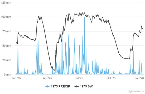
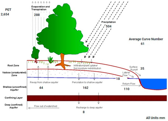
Comprehensive morphometric and hydrometeorological studies on Bacalar Lagoon, Mexico’s largest tropical karstic lake and a significant aquatic system of the Yucatán Peninsula, are lacking. This study provides a detailed analysis of its bathymetry, morphometry, and hydrometeorological characteristics. The lake’s main basin stretches more than 52.7 km in length, with widths varying from 0.18 km to 2.28 km. It has a volume of 554.4 million cubic meters, with an average depth of 8.85 m, reaching depths of up to 26 m in the north and featuring sub-lacustrine dolines in the south, with depths of 38 m, 48.5 m, and 63.6 m. The study reveals seasonal variations in surface water temperature, closely linked to air temperature (r = 0.89), and immediate responses of water levels to hydrometeorological events. Water level fluctuations also exhibit seasonal patterns that are correlated with regional aquifer conditions, with a lag of 2 months after seasonal rainfall. Interannual variability in rainfall and water levels was observed. From 2010 to 2012, rainfall consistently remained below its mean climatic value, due to a prolonged La Niña event, while the exceptionally wet conditions in 2020 were also associated with La Niña. Extreme and anomalous hydrometeorological events, such as those following tropical storm Cristobal in 2020, revealed the fragility of Bacalar Lagoon, causing a notable transformation in lake color and transparency, shifting it from its typical oligotrophic state to eutrophic conditions that lasted longer than a year. These color changes raise questions about the factors impacting ecological health in tropical karstic regions. Additional factors affecting water quality in the BL in 2020, such as deforestation, coastline changes, and urban growth, warrant further investigation. Our study can serve as a starting landmark.
Full article
(This article belongs to the Topic Karst Environment and Global Change)
►
Show Figures

Figure 1


